Related Research Articles

The A44 is a major road in the United Kingdom that runs from Oxford in southern England to Aberystwyth in west Wales.
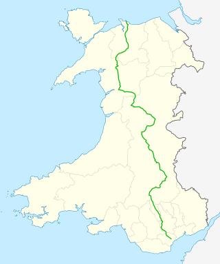
The A470 is a trunk road in Wales. It is the country's longest road at 186 miles (299 km) and links the capital Cardiff on the south coast to Llandudno on the north coast. While previously one had to navigate the narrow roads of Llanidloes and Dolgellau, both these market towns are now bypassed due to extensive road modernisation. The 26 miles (42 km) from Cardiff Bay to Merthyr Tydfil are mainly dual carriageway, but most of the route from north of Merthyr to Llandudno is single carriageway.
The A483, officially described as the Swansea to Manchester Trunk Road, although now ending in Chester, is a major road in the United Kingdom. It runs from Swansea in Wales to Chester in England via Llandovery, Llandrindod Wells, Oswestry and Wrexham, a distance of around 153 miles (246 km).
Rhayader is a market town and community in Powys, Wales, within the historic county of Radnorshire. The town is 20 miles (32 km) from the source of the River Wye on Plynlimon, the highest point of the Cambrian Mountains, and is located at the junction of the A470 road and the A44 road 13 miles (21 km) north of Builth Wells and 30 miles (48 km) east of Aberystwyth.

Builth Wells is a market town and community in the county of Powys and historic county of Brecknockshire (Breconshire), mid Wales, lying at the confluence of rivers Wye and Irfon, in the Welsh part of the Wye Valley. In 2011 it had a population of 2,568.

The Desert of Wales, or Green Desert of Wales, is an archaic term for an area in central Wales, so called for its lack of roads and towns, and its inaccessibility. The term was coined by English travel writers in the nineteenth century and has no equivalent in the Welsh language. The area corresponds roughly to the upland area called Elenydd in Welsh.

Llanelwedd is a village and community near Builth Wells, in Powys, Wales. It lies within the historic boundaries of Radnorshire. Llanelwedd features the Royal Welsh Showground.

Radnor Forest is a rock dome composed of Silurian shales, mudstones and limestone in the historic county of Radnorshire, Powys, Mid Wales. It is a forest in the medieval sense of the word. It lies within the Welsh Marches region since Offa's Dyke lies nearby to the east.

Llangurig is both a village and a community in Montgomeryshire, Powys, Wales. The population was 723 in the 2011 UK Census. The community includes the hamlet of Cwmbelan.
National Cycle Network, Route 43 is part of the National Cycle Network and the Celtic Trail, which connects Swansea with Builth Wells. Most of the route is still awaiting development. As of June 2006, there is a 13-mile section out of Swansea that is open and signed.

Llanwrthwl is a village and community in Powys, mid Wales, and the historic county of Brecknockshire. Llanwrthwl lies off the A470 road, north by road from Builth Wells and Newbridge-on-Wye and south of Rhayader. It lies on the River Wye and River Elan and the village is accessed by a bridge over the Wye. In 1833, its population was 517; its population in 1841 was 568; in 1845, its population was 563.

Nant Glas is a village in the Elan Valley near Rhayader and Llandrindod Wells in Powys, Wales. It is on a side road between the A44 to the northeast and the A470 to the southwest. There is a small chapel at the southern end of the village.

Erwood is a village and community lying beside the River Wye, on the A470 road some 6 miles south-east of Builth Wells in Powys, Wales. The population of the community taken at the 2011 census was 429. It is in the historic county of Brecknockshire (Breconshire) and the older cantref of Cantref Selyf. The community includes the settlements of Crickadarn, Gwenddwr and Llaneglwys.
Newbridge-on-Wye is a small village in Powys, Wales. It lies, as its name suggests, on the River Wye, just downstream from the market town of Rhayader, and in the community of Llanyre.
Upper Chapel is a hamlet in the southern part of the county of Powys in mid Wales. It was formerly in the county of Brecknockshire. It lies on the B4520 road from Brecon to Builth Wells, in the valley of the River Honddu. The south-flowing Honddu cuts deeply into the uplands of Mynydd Epynt north of Brecon. To the north and west of Upper Chapel lies the British Army's Sennybridge Training Area.
Llanfihangel Nant Melan is a small village in Powys, Wales, in the ancient county of Radnorshire. It is around 7 miles (11 km) from the English border. It is in the community of New Radnor.

Afon Irfon is a river in Powys, Wales. It flows from the upper slopes of Bryn Garw in the Cambrian Mountains, through the Abergwesyn Valley, past the Nant Irfon National Nature Reserve in the hills above the village of Abergwesyn, and through Llanwrtyd Wells to its confluence with the River Wye at Builth Wells. The source of the Irfon is in the so-called 'Desert of Wales'.
Dulas is a left-bank tributary of the Afon Irfon, itself a tributary of the River Wye. It rises on the southeastern slopes of the Elenydd and runs southeast to join the Irfon at Garth. The river is bridged by both the B4358 and the A483 roads.

The Llangurig branch was a part of a proposed scheme by the Manchester and Milford Railway (M&MR) to connect industrialised Northwest England with the West Wales deep water port of Milford Haven. After various financial and construction difficulties, the 1.5 miles (2.4 km) of the Llangurig branch is noted as being the shortest lived working branch line in the United Kingdom, receiving only one train.
References
- ↑ "A481". Sabre. Retrieved 4 April 2016.
- ↑ Concise Road Atlas: Britain. AA Publishing. 2015. p. 38. ISBN 978-0-7495-7743-8.