
The North York Moors is an upland area in north-eastern Yorkshire, England. It contains one of the largest expanses of heather moorland in the United Kingdom. The area was designated as a National Park in 1952, through the National Parks and Access to the Countryside Act 1949. Covering an area of 554 sq mi (1,430 km2), the National Park has a population of 23,380. It is administered by the North York Moors National Park Authority, which is based in Helmsley.
The Coast to Coast Walk is a long-distance footpath between the west and east coasts of Northern England, nominally 190-mile (306 km) long. Devised by Alfred Wainwright, it passes through three contrasting national parks: the Lake District National Park, the Yorkshire Dales National Park, and the North York Moors National Park. The current actual measured distance is reported as 182-mile (293 km).
The River Esk is a river in North Yorkshire, England that empties into the North Sea at Whitby after a course of around 28 miles (45 km) through its valley of Eskdale. The river's name is derived from the Brythonic word "isca" meaning "water". The Esk is the only major river in Yorkshire that flows directly into the North Sea; all other watercourses defined as being major rivers by the Environment Agency, either flow to the North Sea via the River Tees or the Humber Estuary.

The Esk Valley Line is a railway line located in the north of England, covering a total distance of approximately 35 miles (56 km), running from Middlesbrough to Whitby. The line follows the course of the River Esk for much of its eastern half.
Westerdale is a village, civil parish and dale within the Scarborough district of North Yorkshire, England. The Esk Valley Walk runs through part of the village. The village is at the confluence of three streams (Esklets) which combine as the head of the River Esk.
Castleton is a village on the River Esk, part of the civil parish of Danby in the county of North Yorkshire in England. It can be found 7.1 miles (11.5 km) south-east of Guisborough, in the North York Moors. There was once a medieval castle sited on Castle Hill that is thought to have been abandoned when Danby Castle was constructed.

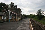
Castleton Moor is a railway station on the Esk Valley Line, which runs between Middlesbrough and Whitby via Nunthorpe. The station, situated 16 miles 45 chains (26.7 km) west of Whitby, serves the village of Castleton, Scarborough in North Yorkshire, England. It is owned by Network Rail and managed by Northern Trains.

Danby is a railway station on the Esk Valley Line, which runs between Middlesbrough and Whitby via Nunthorpe.

Lealholm is a railway station on the Esk Valley Line, which runs between Middlesbrough and Whitby via Nunthorpe. The station, situated 11 miles 40 chains (18.5 km) west of Whitby, serves the village of Lealholm, Scarborough in North Yorkshire, England. It is owned by Network Rail and managed by Northern Trains.

Glaisdale is a railway station on the Esk Valley Line, which runs between Middlesbrough and Whitby via Nunthorpe. The station, situated 9 miles 33 chains (15.1 km) west of Whitby, serves the village of Glaisdale in North Yorkshire, England. It is owned by Network Rail and managed by Northern Trains.
Grosmont is a railway station on the Esk Valley Line, which runs between Middlesbrough and Whitby via Nunthorpe. The station, situated 6 miles 24 chains (10.1 km) west of Whitby, serves the village of Grosmont, in the Borough of Scarborough, North Yorkshire, England. It is owned by Network Rail and managed by Northern Trains. The station is also served by heritage services operated by the North Yorkshire Moors Railway.

Ruswarp is a railway station on the Esk Valley Line, which runs between Middlesbrough and Whitby via Nunthorpe. The station, situated 1 mile 30 chains (2.2 km) south-west of Whitby, serves the village of Ruswarp, Scarborough in North Yorkshire, England. It is owned by Network Rail and managed by Northern Trains.

Goathland railway station is a station on the North Yorkshire Moors Railway and serves the village of Goathland in the North York Moors National Park, North Yorkshire, England. It has also been used in numerous television and film productions. Holiday accommodation is available in the form of a camping coach.

Egton Bridge is a village in the Scarborough district of North Yorkshire, England. It lies within the North York Moors National Park, on the River Esk, between the villages of Glaisdale and Grosmont, about six miles south-west of Whitby, and on the route of the Esk Valley Walk.
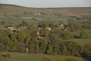
Glaisdale is a village and civil parish in the Scarborough district of North Yorkshire, England, within the North York Moors National Park.

Lealholm is a small village in the Glaisdale civil parish of the Borough of Scarborough, in North Yorkshire, England. It is sited at a crossing point of the River Esk, in Eskdale which is within the North York Moors National Park. It is 9.5 miles (15.3 km) by road from the nearest town of Whitby, and approximately 27 miles (43 km) from both Middlesbrough and Scarborough. The village is typical of those found all across the North York Moors which straddle the main through-routes along the valley bottoms. It is mostly built of local stone with pantiled or slate roofs.

Eskdale is a valley running west to east from Westerdale on the North York Moors to Whitby on the Yorkshire Coast of England. Formed during the last major ice age, it has a classic U-shaped valley formation caused by the action of glaciers carving away the rock. Eskdale is named after its river which in Celtic means water or stream. The dale carries the River Esk from the "Esklets" above Westerdale to the sea at Whitby. The tops of its steep-sided valleys are noted for their heather moorland, whilst below the land is mainly split between pasture for cows and Swaledale sheep and arable crops such as oilseed rape.

The A169 is an A road in North Yorkshire, England. It runs from the A64 at Malton on the edge of the Yorkshire Wolds through the Vale of Pickering and across the North York Moors to join the A171 just west of Whitby. It is a single carriageway for all of its 25-mile (40 km) route. Whilst it is not considered a Primary Route nationally, the Ryedale Local Transport Plan lists it as part of its Major Road Network alongside the A64, A166 and A171.

Beggar's Bridge is a packhorse bridge straddling the River Esk in Glaisdale, North Yorkshire, England. The bridge dates back to 1619 and was reputedly built by a former poor farm worker who wanted to meet his love but could not due to the river being in flood. Having become rich working at sea, then becoming the mayor of Kingston upon Hull, Ferris built the bridge at that point when flooding prevented him crossing it years before. The structure is both a scheduled monument and a grade II* listed building.
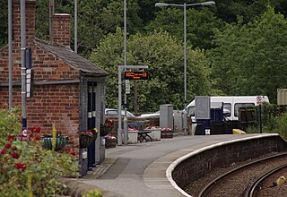
 Castleton Moor railway station - start of the walk
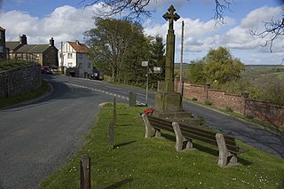
 Danby Methodist Church on the route
 Lealholm War memorial by the route of walk
 Approaching Sleights
 Esk Valley Walk at Ruswarp
 At the outskirts of Whitby near Caedmon School
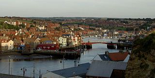
 Whitby West Pier at end of Esk Valley Walk


