At the bottom of the village, the road crosses the Esk Valley Railway, allowing access to Sleights railway station. The road crosses the River Esk on a high bridge, opened on 26 January 1937.[1] The road continues up the hill to reach the A171Whitby to Middlesbrough trunk road. At the top of the village is Blue Bank. Due east of the village is the hamlet of Iburndale.
Due to road accidents, Blue Bank, with a gradient of 1 in 4 (25%), has an escape lane of soft sand.
The Horticultural & Industrial Society show has been held each year since 1880. Since 2006 the show has been held on the sports field, with classes for produce, fruit, flowers vegetables, crafts, cake decorating, photography, flower arranging etc. Additional attractions include a bouncy castle, face painting, tombola and a fun dog show. The infamous Victorian forger Edward Simpson was born here in 1815.
Amenities
There is a village shop, a branch of the Spar chain which includes a Post Office, two public houses, a butchers, Botham’s bakers and a fish and chip restaurant.
Sport
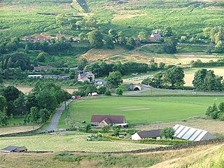
The village sports field, which is mainly used for cricket, has a new pavilion built in 2006. The money for the new build was collected through local fundraising.[2] Until 2018, the cricket team used to play in the Eskdale League on Saturdays. In June 2011, a new Sleights Football club was formed and joined the Scarborough and District Saturday League, with several players coming from Sleights, but training and playing at Caedmon School in Whitby. They were promoted from the league's Third Division to the First in the space of two seasons. They joined the Beckett Football League in 2017 and returned to play at Lowdale Lane in the village after a 20-year absence on Saturday 23 September 2018. Their first game back home was a 4–1 win over Kirkbymoorside Reserves, Joe Hugill scored the first goal.[3] There is also a bowls club which is used by people from Sleights and neighbouring towns and villages.
Education
The village contains only one school, Sleights Church of England primary school. The school has approximately 100 pupils and is graded as Good by Ofsted and SIAMS (2019). Students aged over 11 years old travel to nearby schools in Whitby.
Religion
St John's Church
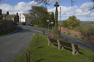
There are three places of worship in the village: the Anglican St John's Church, Sleights, English Martyrs Roman Catholic Church, on Eskdaleside and, at the bottom of the village, the Briggswath and Sleights Methodist Chapel. The churchyard of St John's is the burial place for all denominations in the parish. The author Alfred J. Brown and his wife are buried there.[4] The ruins of the Mediaeval St John's Chapel, Sleights lie above the village.[5]
Name
First found in a document from 1223 as Sleghtesc.[6] Like other place names in Yorkshire, the etymology of Sleights is Old Norse.[7][8] It means 'smooth or level fields'[9] from slétta[10] 'flat land, plain, prairie', like the Norman place name Eslettes (Esletis ab. 1040),[11][12] same etymology as many places in Denmark called Sletten.[13]
↑ François de Beaurepaire, Les Noms des communes et anciennes paroisses de la Seine-Maritime, A. et J. Picard, foreword Marianne Mulon, 1979, Paris, ISBN2-7084-0040-1, oclc 6403150, p.70.
Fylingdales is a civil parish in North Yorkshire, England situated south of Whitby, within the North York Moors National Park. It contains the villages of Robin Hood's Bay and Fylingthorpe and Fyling Hall School.
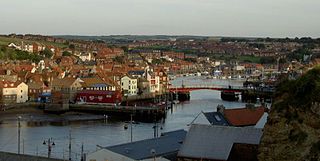
Whitby is a seaside town, port and civil parish in North Yorkshire, England. It is on the Yorkshire Coast at the mouth of the River Esk and has a maritime, mineral and tourist economy.
The River Esk is a river in North Yorkshire, England that empties into the North Sea at Whitby after a course of around 28 miles (45 km) through its valley of Eskdale. The river's name is derived from the Brythonic word "isca" meaning "water". The Esk is the only major river in Yorkshire that flows directly into the North Sea; all other watercourses defined as being major rivers by the Environment Agency, either flow to the North Sea via the River Tees or the Humber Estuary.
The Esk Valley Walk is a long distance footpath in North Yorkshire, England. The route first follows a loop on the North York Moors to the south of Castleton, then shadows the River Esk on its journey to the North Sea. Waymarking uses the symbol of a leaping salmon, with yellow arrows denoting footpaths and blue arrows bridleways.
Grosmont is a village and civil parish situated in Eskdale in the North York Moors National Park, within the boundaries of the Scarborough district of the county of North Yorkshire, England.
Castleton is a village on the River Esk, part of the civil parish of Danby in the county of North Yorkshire in England. It can be found 7.1 miles (11.5 km) south-east of Guisborough, in the North York Moors. There was once a medieval castle sited on Castle Hill that is thought to have been abandoned when Danby Castle was constructed.
Goathland is a village and civil parish in the Scarborough district of North Yorkshire, England. Historically part of the North Riding of Yorkshire, it is in the North York Moors national park due north of Pickering, off the A169 to Whitby. It has a station on the steam-operated North Yorkshire Moors Railway line.
Sleights is a railway station on the Esk Valley Line, which runs between Middlesbrough and Whitby via Nunthorpe. The station, situated 2 miles 78 chains (4.8 km) south-west of Whitby, serves the villages of Briggswath and Sleights, Scarborough in North Yorkshire, England. It is owned by Network Rail and managed by Northern Trains.
Glaisdale is a village and civil parish in the former Scarborough district of North Yorkshire, England, within the North York Moors National Park.
Lealholm is a small village in the Glaisdale civil parish of the former Borough of Scarborough, in North Yorkshire, England. It is sited at a crossing point of the River Esk, in Eskdale which is within the North York Moors National Park. It is 9.5 miles (15.3 km) by road from the nearest town of Whitby, and approximately 27 miles (43 km) from both Middlesbrough and Scarborough. The village is typical of those found all across the North York Moors which straddle the main through-routes along the valley bottoms. It is mostly built of local stone with pantiled or slate roofs.
Eskdale is a valley running west to east from Westerdale on the North York Moors to Whitby on the Yorkshire Coast of England. Formed during the last major ice age, it has a classic U-shaped valley formation caused by the action of glaciers carving away the rock. Eskdale is named after its river which in Celtic means water or stream. The dale carries the River Esk from the "Esklets" above Westerdale to the sea at Whitby. The tops of its steep-sided valleys are noted for their heather moorland, whilst below the land is mainly split between pasture for cows and Swaledale sheep and arable crops such as oilseed rape.
Ruswarp is a village in the civil parish of Whitby, in North Yorkshire, England. It is around 1.8 miles (2.9 km) from Whitby, at the junction of the B1410 and B1416 roads, on the River Esk and the Esk Valley Line, with trains stopping at Ruswarp railway station. Originally it was called Risewarp meaning 'silted land overgrown with brushwood'.
Eskdaleside cum Ugglebarnby is a civil parish in North Yorkshire, England, comprising the two villages of Sleights and Ugglebarnby.
Briggswath is a village in the Scarborough district of North Yorkshire, England. the settlement is on the north bank of the River Esk, upstream of Ruswarp, and opposite Sleights which is on the south bank.
Hawsker-cum-Stainsacre is a civil parish in the former Scarborough district of North Yorkshire, England. The population of the parish was listed as being 710 at the 2021 Census.
The A169 is an A road in North Yorkshire, England. It runs from the A64 at Malton on the edge of the Yorkshire Wolds through the Vale of Pickering and across the North York Moors to join the A171 just west of Whitby. It is a single carriageway for all of its 25-mile (40 km) route. Whilst it is not considered a Primary Route nationally, the Ryedale Local Transport Plan lists it as part of its Major Road Network alongside the A64, A166 and A171.
Eskdaleside cum Ugglebarnby is a civil parish in the Scarborough district of North Yorkshire, England. It contains 38 listed buildings that are recorded in the National Heritage List for England. All the listed buildings are designated at Grade II, the lowest of the three grades, which is applied to "buildings of national importance and special interest". The parish contains the settlements of Sleights, Ugglebarnby, Briggswath and Iburndale, and the surrounding countryside. Most of the listed buildings are houses, cottages and associated structures, farmhouses and farm buildings. The others include churches, a monument in a churchyard, a ruined chapel, boundary stones, a milepost, a public house, a former railway station, a drinking fountain, and a commemorative obelisk.
All Saints' Church is an Anglican church in Ugglebarnby, a village in North Yorkshire, in England.
St John's Church is an Anglican church in Sleights, a village in North Yorkshire, in England.
St John's Chapel is a ruined Anglican chapel in Sleights, a village in North Yorkshire, in England.
This page is based on this Wikipedia article Text is available under the CC BY-SA 4.0 license; additional terms may apply. Images, videos and audio are available under their respective licenses.