Rhinogydd

Last updated

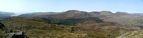
The Rhinogydd (a Welsh plural form, often anglicised as Rhinogs and also known by the alternative Welsh plural Rhinogau) are a range of mountains located east of Harlech in North Wales. The name Rhinogydd derives from the names of two of the more famous peaks, Rhinog Fawr and Rhinog Fach, although the greatest elevation in the range is reached by Y Llethr, 756 m (2,480 feet).

Contents

Foel Penolau, the northernmost summit of the range, was promoted to a Hewitt in 2018 due to a new survey. [1]

Rhinog Fach and Y Llethr from the slopes of Rhinog Fawr Rhinog Fach and Y Llethr.JPG
Rhinog Fach and Y Llethr from the slopes of Rhinog Fawr

The Rhinogydd are notably rocky and heather-clad towards the northern end of the range, especially around Rhinog Fawr, Rhinog Fach and towards Moel Ysgyfarnogod. The southern end, around Y Llethr, Diffwys and the Ysgethin Valley has a softer, grassy character.

A population of feral goats are in the range. Over 30 km² are protected as a Special Area of Conservation and a National Nature Reserve.

Geology

The Rhinogydd are formed of hard sedimentary rocks of Cambrian age which occur as a major anticlinal structure known to geologists as the Harlech Dome. This structure which originated during the Caledonian Orogeny (mountain-building period) extends from Cadair Idris in the south to Blaenau Ffestiniog in the north. Its erosion by successive glaciations has left the valleys and peaks of the Rhinogydd visible today. [2] The core of the area is formed from the hard-wearing greywackes of the Rhinog Formation. The formation also contains and is overlain by some siltstones and mudstones which form a broken zone of softer scenery around the periphery of the area's rugged core. In places, swarms of dolerite dykes cut through the country rocks in a generally northwest–southeast direction. Much of the lower ground is mantled by glacial till, a legacy of the last glaciation. [3]

History of geological investigations

The geology of the area was first characterised by Adam Sedgwick and Roderick Murchison in 1835. [4] The Geological Survey began work in the area in 1846 and their first maps were published in 1855. [5] With the discovery of gold in the area in 1846 the state of geological knowledge increased dramatically. At least a dozen major publications appeared between 1844 and 1939.

Hillwalking in the Rhinogydd

The Rhinogydd are far less well known than the areas in the north of the Snowdonia National Park, such as the Glyderau, Carneddau and the Snowdon massif itself. This is due to the rugged nature of the landscape in the Rhinogydd and the fame of Snowdon as the highest peak in Wales. The Rhinog mountains are popular with hillwalkers looking for a more isolated, wilder walking experience.

The peaks of the range are most easily accessed from the west side. Two valleys - Cwm Nantcol ('valley of the Nantcol (stream)') and Cwm Bychan ('small valley') - lead deep into the mountains and may be reached from the village of Llanbedr.

The most popular walking route in this area begins at the Roman Steps at 52°51′16.76″N4°0′18.43″W / 52.8546556°N 4.0051194°W / 52.8546556; -4.0051194 , which leads from Cwm Bychan through Bwlch Tyddiad and around Rhinog Fawr. Despite the name, these steps are not Roman and are in fact the well preserved remains of a medieval packhorse trail leading from Chester to Harlech Castle. At the top of the Roman Steps, the route curves around the eastern end of Rhinog Fawr and enters Cwm Nantcol via Bwlch Drws Ardudwy ('pass of the doorway of Ardudwy'). A different path leads from Cwm Nantcol, passing around the western end of Rhinog Fawr back to Cwm Bychan via Gloywlyn ('gleaming lake'), completing a circular route that can easily be completed in a day.

Main peaks

Panorama of the Rhinogau from the summit of Y Garn with the River Mawddach estuary at far left and Diffwys, Crib y Rhiw, Y Llethr, Rhinog Fach and Rhinog Fawr from left to right Rhinogau panorama.jpg
Panorama of the Rhinogau from the summit of Y Garn with the River Mawddach estuary at far left and Diffwys, Crib y Rhiw, Y Llethr, Rhinog Fach and Rhinog Fawr from left to right

The range contains the following Marilyns:

the following Hewitts:

and the following Nuttalls:

Related Research Articles

<span class="mw-page-title-main">Snowdonia</span> Mountainous region and national park in north Wales

Snowdonia, or Eryri, is a mountainous region and national park in North Wales. It contains all 15 mountains in Wales over 3000 feet high, including the country's highest, Snowdon, which is 1,085 metres (3,560 ft) tall. These peaks are all part of the Snowdon, Glyderau, and Carneddau ranges in the north of the region. The shorter Moelwynion and Moel Hebog ranges lie immediately to the south.

<span class="mw-page-title-main">Snowdon</span> Mountain in Snowdonia, Wales

Snowdon, or Yr Wyddfa, is a mountain in the Snowdonia region of North Wales. It has an elevation of 1,085 metres (3,560 ft) above sea level, which makes it both the highest mountain in Wales and the highest in the British Isles south of the Scottish Highlands. Snowdon is designated a national nature reserve for its rare flora and fauna, and is located within Snowdonia National Park.

<span class="mw-page-title-main">Y Llethr</span> Mountain in Snowdonia, Wales

Y Llethr is the highest mountain in the Rhinogydd range of Snowdonia, in north Wales. The summit consists of a flat grassy top marked only by a small cairn. The summit is more in keeping with its southern flanks than its rugged northern approach.

<span class="mw-page-title-main">Glyderau</span> Mountain group in Wales

The Glyderau are a mountain group in Snowdonia, North Wales. The name derives from the highest peaks in the range, Glyder Fawr and Glyder Fach. According to Sir Ifor Williams, the word "Glyder" derives from the Welsh word "Cludair", meaning a heap of stones.

<span class="mw-page-title-main">Carneddau</span> Mountain group in Wales

The Carneddau are a group of mountains in Snowdonia, Wales. They include the largest contiguous areas of high ground in Wales and England, as well as six or seven of the highest peaks in the country—the Fifteen Peaks. The range also encloses a number of lakes such as Llyn Cowlyd and Llyn Eigiau, and the Aber Falls waterfall. It is delimited by the Irish Sea to the north, the Conwy valley to the east, and by the A5 road from Betws-y-Coed to Bethesda to the south and west. The area covers nearly 200 square kilometres (80 sq mi), about 10% of the area of Snowdonia. The area is bordered by three main roads—the A55, the A5 to the south and the A470 to the east.

<span class="mw-page-title-main">Glyder Fawr</span> Mountain in Snowdonia, Wales

Glyder Fawr is a mountain in Snowdonia, Wales, the highest peak in the Glyderau range at just over 1,000 metres. It is the fifth-highest mountain in Wales and has several walking and scrambling routes leading to its summit. According to Sir Ifor Williams, the word "Glyder" derives from the Welsh word "Gludair", meaning a heap of stones.

<span class="mw-page-title-main">Elidir Fawr</span> Mountain in Wales

Elidir Fawr is a mountain in Snowdonia, north Wales, the northernmost peak in the Glyderau. Its name means 'Big Elidir', named after a legendary warrior king of the 6th century also known as Eliffer Gosgorddfawr.

<span class="mw-page-title-main">Arenig Fawr</span>

Arenig Fawr is a mountain in Snowdonia, North Wales, close to Llyn Celyn reservoir, alongside the A4212 between Trawsfynydd and Bala.

<span class="mw-page-title-main">Rhinog Fawr</span> Mountain in Snowdonia, Wales

Rhinog Fawr is a mountain in Snowdonia, North Wales and forms part of the Rhinogydd range. It is the third highest summit of the Rhinogydd, losing out to Y Llethr and Diffwys respectively. Its smaller cousin Rhinog Fach lies to the south, separated by the pass of Bwlch Drws Ardudwy, while its other neighbour, Moel Ysgyfarnogod lies to the north.

<span class="mw-page-title-main">Rhinog Fach</span> Mountain in Snowdonia, Wales

Rhinog Fach is a mountain in Snowdonia, North Wales and forms part of the Rhinogydd. Technically, Rhinog Fach is a subsidiary summit of Y Llethr, but is a Marilyn. To the north lies its higher cousin Rhinog Fawr, separated by the shapely pass of Bwlch Drws Ardudwy.

<span class="mw-page-title-main">Moelfre (hill)</span>

Moelfre is a hill in Wales on the far western edge of the Snowdonia National Park, 3 miles (4.8 km) from the village of Dyffryn Ardudwy, 5 miles (8.0 km) from the village of Llanbedr and about 10 miles (16 km) from the town of Harlech. It forms part of the Rhinogydd range. Moelfre reaches a height of 589 metres (1,932 ft).

<span class="mw-page-title-main">River Artro</span> River in Gwynedd, Wales

The River Artro is a river in Gwynedd, Wales.

<span class="mw-page-title-main">Afon Cwmnantcol</span> River in North Wales

The River Cwmnantcol is a river in North Wales.

Cwm Nantcol is a valley in the Ardudwy area of the county of Gwynedd in Wales.

<span class="mw-page-title-main">Carnedd y Filiast (Cerrigydrudion)</span> Mountain in Gwynedd, Wales

Carnedd y Filiast is a mountain near Cerrigydrudion on the border of the Snowdonia National Park, North Wales and is 669 metres (2,195 ft) high.

<span class="mw-page-title-main">Arenig Fach</span>

Arenig Fach is a mountain in southern Snowdonia, north Wales. It is a peak in the Arenig range and lies to the north of its parent peak Arenig Fawr.

<span class="mw-page-title-main">Picws Du</span> Mountain (749.1m) in Carmarthenshire, Wales

Picws Du is the second highest peak of the Carmarthen Fans in the Carmarthenshire section of the Black Mountain in the west of the Brecon Beacons National Park in south Wales. The highest peak is Fan Foel immediately next along the ridge and it is a subsidiary summit of Fan Brycheiniog. Picws Du falls within Fforest Fawr Geopark and its prominent summit is marked by a large Bronze Age round barrow at a height of 2457 feet above sea level. Waun Lefrith is the other, lower summit of the Bannau Sir Gâr / Carmarthen Fans situated to the west. The peak overlooks the glacial lake of Llyn y Fan Fach in the cwm below. As the peak sits on the edge of the escarpment on a ridge which juts out into the valley below, the views from the summit are panoramic and extensive. The views to the north are especially impressive when the weather is clear, looking towards the Cambrian Mountains, Mynydd Epynt and Brecon. Swansea and the Bristol Channel can just be seen on the horizon to the south, across the gently falling dip slope. Pen y Fan and Corn Du are distinctive landmarks seen directly to the east across Fforest Fawr.

<span class="mw-page-title-main">Geology of Snowdonia National Park</span> Overview of geology in Snowdonia, Wales

The geology of Snowdonia National Park in North Wales is dominated by sedimentary and volcanic rocks from the Cambrian and Ordovician periods with intrusions of Ordovician and Silurian age. There are Silurian and Cenozoic sedimentary rocks on the park's margins. The succession was intensely faulted and folded during the Caledonian Orogeny. The region was uplifted as the North Atlantic Ocean opened during the Cenozoic. The current mountainous landscape arises from repeated glaciations during the Quaternary period.

<span class="mw-page-title-main">Afon Ysgethin</span> River in Gwynedd, Wales

The Afon Ysgethin is a short river in Gwynedd, Wales. Flowing entirely within Snowdonia National Park it rises beneath the peaks of Y Llethr and Diffwys within the Rhinogs mountain range and runs in a generally ESE direction towards Cardigan Bay.

References

  1. "Foel Penolau: How a Welsh hill became a mountain". BBC News. Retrieved 9 December 2018.
  2. Snowdonia National Park - The geology of Snowdonia Archived 2013-09-16 at the Wayback Machine Retrieved 5 January 2012
  3. British Geological Survey 1:50,000 scale geological map sheet 135/149 Harlech
  4. Sedgwick, A. and Murchison, R.I. 'On the Silurian and Cambrian systems, exhibiting the order in which the older sedimentary strata succeed each other in England and Wales' Rep. Br. Assoc. Adv. Sci. (for 1835 Dublin), Trans., Sect., 59-61
  5. Allen, P.M. and Jackson, A.A. "Geology of the Country Around Harlech" British Geological Survey 1985 ISBN   0-11-884367-2


52°48′49.64″N3°59′18.34″W / 52.8137889°N 3.9884278°W / 52.8137889; -3.9884278