The Rhinogydd are a range of mountains located east of Harlech in North Wales. The name Rhinogydd derives from the names of two of the more famous peaks, Rhinog Fawr and Rhinog Fach, although the greatest elevation in the range is reached by Y Llethr, 756 m.

Glyder Fawr is a mountain in Snowdonia, Wales, the highest peak in the Glyderau range at just over 1,000 metres, having had its height recalculated in 2010 using GPS. It is the fifth-highest mountain in Wales and has several walking and scrambling routes leading to its summit. According to Sir Ifor Williams, the word "Glyder" derives from the Welsh word "Gludair", meaning a heap of stones.

Glyder Fach is a mountain in Snowdonia, north-west Wales, and is the second highest of the Glyderau and the sixth highest in Wales. Routes to the summit lead from Tryfan and Bristly Ridge to the north, via Glyder Fawr from Pen-y-Pass to the south, and along the Glyder ridge to the east, towards Capel Curig. It is a popular spot for climbers.
Moel Siabod is a mountain in Snowdonia, Wales, which sits isolated above the village of Dolwyddelan. At 872 metres (2,861 ft), it is the highest peak in the Moelwynion mountain range. The UK National Mountain Centre, Plas-y-Brenin, is located at the foot of Moel Siabod. From the top of the mountain, it is reputedly possible to see 13 of the 14 highest peaks in Wales on a clear day without turning one's head.

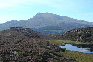
Moel Hebog is a mountain in Snowdonia, north Wales which dominates the view west from the village of Beddgelert. It gives name to a whole range of peaks in the north-western corner of Snowdonia, which include the Nantlle Ridge and Mynydd Mawr.

Waun Fach is, with a summit height of 811 metres (2,661 ft), the highest mountain in the Black Mountains in south-eastern Wales. It is one of the three Marilyns over 600 m that make up the range, the others being Black Mountain and Mynydd Troed. To the north Rhos Fawr and the Radnor Forest can be seen. It is the third highest mountain in Britain south of Snowdonia. It is situated at the head of the Grwyne Fechan valley, above and to the west of the Grwyne Fawr reservoir. It has an undistinguished rounded summit. The nearby tops on the ridge, Pen Trumau and Pen y Gadair Fawr, although lower, are very much more recognisable.

Arenig Fawr is a mountain in Snowdonia, North Wales, close to Llyn Celyn reservoir, alongside the A4212 between Trawsfynydd and Bala.

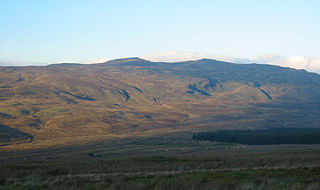
Pen Llithrig y Wrach is a mountain peak in Snowdonia, Wales. It is one of the four Marilyns that make up the Carneddau range. To the east is Creigiau Gleision, another Marilyn, while to the west is Pen yr Helgi Du and Carnedd Llewelyn. Craig Eigiau and Llyn Eigiau can be seen to the north, while Gallt yr Ogof, Glyder Fach and Tryfan can be viewed to the south.

Moel Eilio is a mountain in Snowdonia, North Wales, that is situated approximately 3 miles north-west of Snowdon itself. It has two subsidiary tops, Foel Gron and Foel Goch (Eilio). The average annual temperature of the mountain is around 6 °C. During the winter season, some significant accumulations of snowfall is known to take place on Moel Eilio, due to its relatively flat, grassy slopes.
Moel Cynghorion is a mountain in Snowdonia, North Wales. It lies two miles north-west of Snowdon, and forms part of the Moel Eilio Horseshoe walk. The summit is situated on a wide plateau, marked by a pile of stones. The southern slopes are gentle, while the northern aspect is precipitous. The summit has close views of Clogwyn Du'r Arddu and Snowdon. Views from the summit can extend as far as Holyhead in Anglesey to nearby towns and villages in Gwynedd such as Caernarfon, Llanrug and Llanberis. On a clear day the Wicklow Mountains in Ireland can be seen across the Irish Sea, at a distance of approximately 80 miles.

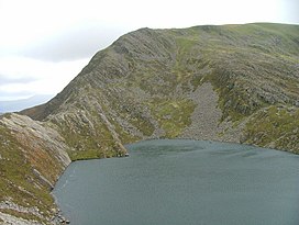
Rhinog Fawr is a mountain in Snowdonia, North Wales and forms part of the Rhinogydd range. It is the third highest summit of the Rhinogydd, losing out to Y Llethr and Diffwys respectively. Its smaller cousin Rhinog Fach lies to the south, separated by the pass of Bwlch Drws Ardudwy, while its other neighbour, Moel Ysgyfarnogod lies to the north.

Rhinog Fach is a mountain in Snowdonia, North Wales and forms part of the Rhinogydd. Technically, Rhinog Fach is a subsidiary summit of Y Llethr, but is a Marilyn. To the north lies its higher cousin Rhinog Fawr, separated by the shapely pass of Bwlch Drws Ardudwy.

Moel Ysgyfarnogod is a mountain in Snowdonia, North Wales and is the northernmost of the Rhinogydd. Rhinog Fawr lies directly south.

Tal y Fan is an outlying peak of the Carneddau mountains in northern Wales. It is one of the four Marilyns that make up the Carneddau, the others being Carnedd Llywelyn, Pen Llithrig y Wrach and Creigiau Gleision.

Aran Benllyn is a subsidiary summit of Aran Fawddwy in southern Snowdonia, North Wales, Wales, United Kingdom. It is the second highest peak in the Aran mountain range.
Cwm Nantcol is a valley in the Ardudwy area of the county of Gwynedd in Wales.
Y Foel Goch is a mountain in Snowdonia, north-west Wales, and is a sister peak along with Gallt yr Ogof to Glyder Fach. Between Glyder Fach and its summit lies Llyn Caseg-fraith, a popular lake for photographing Tryfan and its reflection.

Arenig Fach is a mountain in southern Snowdonia, north Wales. It is a peak in the Arenig range and lies to the north of its parent peak Arenig Fawr.
Gallt y Daren is a peak in the southern half of the Snowdonia National Park in Gwynedd, North Wales, and forms part of the Arenig mountain range. It is a top of Moel Llyfnant, and is twin peaked. It lies to the west of Moel Llyfnant.

Foel Goch is a mountain in north-east Wales, and forms part of the Arenig mountain range. It is the only member of the Arenig group that lies outside of the Snowdonia National Park.