
The Berwyn range is an isolated and sparsely populated area of moorland in the northeast of Wales, roughly bounded by Llangollen in the northeast, Corwen in the northwest, Bala in the southwest, and Oswestry in the southeast.

The Rhinogydd are a range of mountains located east of Harlech in North Wales. The name Rhinogydd derives from the names of two of the more famous peaks, Rhinog Fawr and Rhinog Fach, although the greatest elevation in the range is reached by Y Llethr, 756 m.

Y Llethr is the highest mountain in the Rhinogydd range of Snowdonia, in north Wales. The summit consists of a flat grassy top marked only by a small cairn. The summit is more in keeping with its southern flanks than its rugged northern approach.

Aran Fawddwy is a mountain in southern Snowdonia, Wales, United Kingdom. It is the highest point of the historic county of Merionethshire. It is the highest peak in the Aran mountain range, the only peak in Wales outside North Snowdonia above 900m, and higher than anywhere in the United Kingdom outside Northern Snowdonia, the Scottish Highlands and the Lake District. The nearest small settlements to the mountain are Dinas Mawddwy to the south, Llanymawddwy to the southeast, Llanuwchllyn on the shores of Bala Lake to the north, and Rhydymain to the west. The nearest settlements with around 2,000 people are Bala and Dolgellau. On the eastern slopes of Aran Fawddwy is the small lake named Creiglyn Dyfi, the source of the River Dyfi. Its sister peak is Aran Benllyn at 885 metres (2,904 ft). There is also a middle peak: Erw y Ddafad-ddu.

Moel Hebog is a mountain in Snowdonia, north Wales which dominates the view west from the village of Beddgelert. It gives name to a whole range of peaks in the north-western corner of Snowdonia, which include the Nantlle Ridge and Mynydd Mawr.
Cadair Berwyn, Cader Berwyn or Craig Uchaf is a mountain summit in north-east Wales with a height of 832 metres (2,730 ft) above sea level. It is the highest point in the Berwyn range, the highest in North East Wales and the highest significant summit in Wales outside the National Parks. Cadair Berwyn and Foel Cedig to the west are the two Marilyns that form the Berwyn range. The undulating plateau of the range also includes a large number of other summits above 2,000 feet (610 m), including satellite summits of Cadair Berwyn and many which are classed as Nuttalls.

The Black Mountains are a group of hills spread across parts of Powys and Monmouthshire in southeast Wales, and extending across the England–Wales border into Herefordshire. They are the easternmost of the four ranges of hills that comprise the Brecon Beacons National Park, and are frequently confused with the westernmost, which is known as the Black Mountain. The Black Mountains may be roughly defined as those hills contained within a triangle defined by the towns of Abergavenny in the southeast, Hay-on-Wye in the north and the village of Llangors in the west. Other gateway towns to the Black Mountains include Talgarth and Crickhowell. The range of hills is well known to walkers and ramblers for the ease of access and views from the many ridge trails, such as that on the Black Hill in Herefordshire, at the eastern edge of the massif. The range includes the highest public road in Wales at Gospel Pass, and the highest point in southern England at Black Mountain.

Waun Fach is, with a summit height of 811 metres (2,661 ft), the highest mountain in the Black Mountains in south-eastern Wales. It is one of the three Marilyns over 600 m that make up the range, the others being Black Mountain and Mynydd Troed. To the north Rhos Fawr and the Radnor Forest can be seen. It is the third highest mountain in Britain south of Snowdonia. It is situated at the head of the Grwyne Fechan valley, above and to the west of the Grwyne Fawr reservoir. It has an undistinguished rounded summit. The nearby tops on the ridge, Pen Trumau and Pen y Gadair Fawr, although lower, are very much more recognisable.

Pen Llithrig y Wrach is a mountain peak in Snowdonia, North Wales. It is one of the four Marilyns that make up the Carneddau range. To the east is Creigiau Gleision, another Marilyn, while to the west are Pen yr Helgi Du and Carnedd Llewelyn. Craig Eigiau and Llyn Eigiau can be seen to the north, while Gallt yr Ogof, Glyder Fach and Tryfan can be viewed to the south.

Rhinog Fawr is a mountain in Snowdonia, North Wales and forms part of the Rhinogydd range. It is the third highest summit of the Rhinogydd, losing out to Y Llethr and Diffwys respectively. Its smaller cousin Rhinog Fach lies to the south, separated by the pass of Bwlch Drws Ardudwy, while its other neighbour, Moel Ysgyfarnogod lies to the north.

Rhinog Fach is a mountain in Snowdonia, North Wales and forms part of the Rhinogydd. Technically, Rhinog Fach is a subsidiary summit of Y Llethr, but is a Marilyn. To the north lies its higher cousin Rhinog Fawr, separated by the shapely pass of Bwlch Drws Ardudwy.
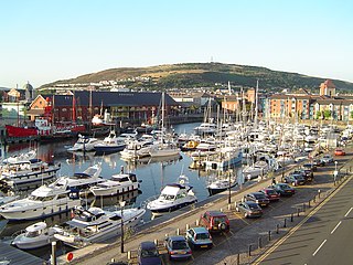
Kilvey Hill is a hill in the St. Thomas area of Swansea. It is193 metres (633 ft) high and is classed as a Sub Marilyn. The top of Kilvey Hill enjoys panoramic views of Swansea city centre, Swansea Docks, Swansea Bay, ad the Lower Swansea Valley. The historic name of the hill in Welsh is Y Bigwrn, with its summit known as Pen y Bigwrn. Currently, however, it is generally known as Mynydd Cilfái.

Tal y Fan is an outlying peak of the Carneddau mountains in North Wales. It is one of the four Marilyns that make up the Carneddau, the others being Carnedd Llywelyn, Pen Llithrig y Wrach and Creigiau Gleision.
Crib-y-rhiw is a top of Y Llethr and a ridge in the Rhinogydd of Snowdonia, north Wales. The summit straddles a thin ridge connecting Y Llethr to Diffwys.

Gau Graig is a subsidiary summit of Cadair Idris in the Snowdonia National Park, in Gwynedd, northwest Wales. It lies to the east of Mynydd Moel on a broad grassy plateau. It marks the eastern end of the Cadair Idris ridge.

Cyrniau Nod is a mountain summit in north east Wales. It is a former Marilyn, the Marilyn summit now being the nearby Foel Cedig. Its summit has the Snowdonia National Park boundary running through it. A number of rivers and streams rise from near the mountain including Afon Tanat, Afon Cedig and Nant Ystrad-y-Groes.

Tarren y Gesail is a mountain in Snowdonia, north Wales. It is one of the Marilyns of the Cadair Idris group.

Diffwys West Top is a top of Diffwys in Snowdonia, North Wales, near Barmouth and forms part of the Rhinogydd. It is a grassy summit found on the west ridge. The summit is marked with a pile of stones, below which is the crags of Craig Bodlyn and the glacial lake, Llyn Bodlyn. Moelfre is to the north.
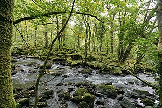
The Afon Ysgethin is a short river in Gwynedd, Wales. Flowing entirely within Snowdonia National Park it rises beneath the peaks of Y Llethr and Diffwys within the Rhinogs mountain range and runs in a generally ESE direction towards Cardigan Bay.

