Snowdonia is a mountainous region in northwestern Wales and a national park of 823 square miles (2,130 km2) in area. It was the first to be designated of the three national parks in Wales, in 1951. It contains the highest peaks in the United Kingdom outside of Scotland.

The Brecon Beacons is a mountain range in South Wales. In a narrow sense, the name refers to the range of Old Red Sandstone peaks which lie to the south of Brecon. Sometimes referred to as "the central Beacons" they include South Wales' highest mountain, Pen y Fan. The range forms the central section of the Brecon Beacons National Park, a designation which also encompasses ranges both to the east and the west of "the central Beacons". This much wider area is also commonly referred to as "the Brecon Beacons", and it includes the Black Mountains to the east as well as the similarly named but quite distinct Black Mountain to the west. The highest peaks include Fan Brycheiniog to the west and Pen y Fan in the central part. They share the same basic geology as the central range, and so exhibit many similar features, such as the north-facing escarpment and glacial features such as lakes and cwms (cirques) below the escarpment. They all fall within the border of the national park.

Snowdon is the highest mountain in Wales, at an elevation of 1,085 metres (3,560 ft) above sea level, and the highest point in the British Isles outside the Scottish Highlands. It is located in Snowdonia National Park in Gwynedd. It is the busiest mountain in the United Kingdom and the third most visited attraction in Wales, with 582,000 people visiting annually. It is designated as a national nature reserve for its rare flora and fauna.

The Berwyn range is an isolated and sparsely populated area of moorland in the northeast of Wales, roughly bounded by Llangollen in the northeast, Corwen in the northwest, Bala in the southwest, and Oswestry in the southeast.

Garnedd Ugain, often referred to as "Crib-y-Ddysgl", is a mountain in Wales that forms part of the Snowdon Massif. It is the second highest peak in Wales, and lies just under one kilometre north of the summit of Snowdon itself.

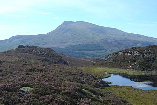
Pen y Fan is the highest peak in south Wales, situated in the Brecon Beacons National Park. At 886 metres (2,907 ft) above sea-level, it is also the highest British peak south of Cadair Idris in Snowdonia. The twin summits of Pen y Fan and Corn Du at 873 m were formerly referred to as Cadair Arthur or 'Arthur's Seat'.

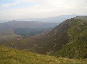
Aran Fawddwy is a mountain in southern Snowdonia, Wales, United Kingdom. It is the only peak in Wales outside North Snowdonia above 900m, and higher than anywhere in Great Britain outside Northern Snowdonia, the Scottish Highlands and the Lake District. The nearest urban centres to the mountain are Dinas Mawddwy to the south, Llanymawddwy to the southeast, Llanuwchllyn on the shores of Bala Lake to the north, and Rhydymain to the west. The nearest settlements with around 2,000 people are Bala and Dolgellau. On the eastern slopes of Aran Fawddwy is the small lake named Creiglyn Dyfi, the source of the River Dyfi. Its sister peak is Aran Benllyn at 885 metres (2,904 ft). There is also a middle peak- Erw y Ddafad-ddu.

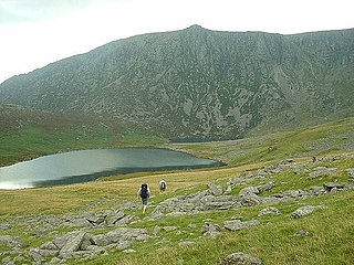
Glyder Fach is a mountain in Snowdonia, north-west Wales, and is the second highest of the Glyderau and the sixth highest in Wales. Routes to the summit lead from Tryfan and Bristly Ridge to the north, via Glyder Fawr from Pen-y-Pass to the south, and along the Glyder ridge to the east, towards Capel Curig. It is a popular spot for climbers.
Moel Siabod is a mountain in Snowdonia, North Wales, which sits isolated above the villages of Betws-y-Coed and Capel Curig. At 872m it is the highest peak in the Moelwynion mountain range. The UK National Mountain Centre, Plas-y-Brenin, is located at the foot of Moel Siabod. From the top of the mountain, it is reputedly possible to see 13 of the 14 highest peaks in Wales on a clear day without turning one's head.

Cadair Berwyn or Cader Berwyn is a mountain summit in north east Wales. It is the highest point in the Berwyn range, and the highest significant summit in Wales outside the National Parks. Cadair Berwyn and Cyrniau Nod to the west are the two Marilyns that form the Berwyn range.

Waun Fach is the highest mountain at 2661 feet in the Black Mountains in south-eastern Wales. It is one of the three Marilyns over 600m that make up the range, the others being Black Mountain and Mynydd Troed. To the north Rhos Fawr and the Radnor Forest can be seen. It is the third highest mountain in mainland Britain south of Snowdonia.

Rhinog Fawr is a mountain in Snowdonia, North Wales and forms part of the Rhinogydd range. It is the third highest summit of the Rhinogydd, losing out to Y Llethr and Diffwys respectively. Its smaller cousin Rhinog Fach lies to the south, separated by the pass of Bwlch Drws Ardudwy, while its other neighbour, Moel Ysgyfarnogod lies to the north.

Rhinog Fach is a mountain in Snowdonia, North Wales and forms part of the Rhinogydd. Technically, Rhinog Fach is a subsidiary summit of Y Llethr, missing Marilyn status by 3m. Thus making it a sub Marilyn along with Diffwys. To the north lies its higher cousin Rhinog Fawr, separated by the shapely pass of Blwch Drws Ardudwy.

Diffwys is a mountain in Snowdonia, North Wales, near Barmouth and forms part of the Rhinogydd. On the north side is an exposure of the Caerdion Syncline. It is technically a subsidiary summit of Y Llethr, missing Marilyn status by 2m. It is therefore like Rhinog Fach a sub Marilyn.
Craig Cwm Silyn is a mountain in Snowdonia, North Wales which forms the highest point on the celebrated Nantlle Ridge.
Pilleth is a small village south of Knighton in Powys, Wales. It is the site of the ancient church and holy well of St. Mary’s which stands on Bryn Glas Hill overlooking the River Lugg, as it makes its way to Presteigne.
The River Cwmnantcol is a river in North Wales.

Cefn-y-bedd is a village in Flintshire, north-east Wales.