
Snowdon, or Yr Wyddfa, is a mountain in the Snowdonia region of North Wales. It has an elevation of 1,085 metres (3,560 ft) above sea level, which makes it both the highest mountain in Wales and the highest in the British Isles south of the Scottish Highlands. Snowdon is designated a national nature reserve for its rare flora and fauna, and is located within Snowdonia National Park.
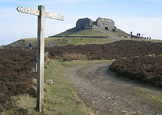
Moel Famau is the highest hill in the Clwydian Range and the highest point of the county of Flintshire in Wales. It lies on the boundary between Denbighshire and Flintshire. The hill, which also gives its name to the Moel Famau country park, has been classed as an Area of Outstanding Natural Beauty since 1985. It is also surrounded by several well-preserved Iron Age hill forts. It is also the third-highest peak in the extended AONB of the Clwydian Range and Dee Valley.

The Rhinogydd are a range of mountains located east of Harlech in North Wales. The name Rhinogydd derives from the names of two of the more famous peaks, Rhinog Fawr and Rhinog Fach, although the greatest elevation in the range is reached by Y Llethr, 756 m.

Y Llethr is the highest mountain in the Rhinogydd range of Snowdonia, in north Wales. The summit consists of a flat grassy top marked only by a small cairn. The summit is more in keeping with its southern flanks than its rugged northern approach.

Pen y Fan is the highest peak in South Wales, situated in Brecon Beacons National Park. At 886 metres (2,907 ft) above sea-level, it is also the highest British peak south of Cadair Idris in Snowdonia. It is the highest point of the historic county of Brecknockshire. The twin summits of Pen y Fan and Corn Du at 873 metres (2,864 ft) were formerly referred to as Cadair Arthur or 'Arthur's Seat'.

Aran Fawddwy is a mountain in southern Snowdonia, Wales, United Kingdom. It is the highest point of the historic county of Merionethshire. It is the highest peak in the Aran mountain range, the only peak in Wales outside North Snowdonia above 900m, and higher than anywhere in the United Kingdom outside Northern Snowdonia, the Scottish Highlands and the Lake District. The nearest small settlements to the mountain are Dinas Mawddwy to the south, Llanymawddwy to the southeast, Llanuwchllyn on the shores of Bala Lake to the north, and Rhydymain to the west. The nearest settlements with around 2,000 people are Bala and Dolgellau. On the eastern slopes of Aran Fawddwy is the small lake named Creiglyn Dyfi, the source of the River Dyfi. Its sister peak is Aran Benllyn at 885 metres (2,904 ft). There is also a middle peak: Erw y Ddafad-ddu.

Cadair Berwyn, Cader Berwyn or Craig Uchaf is a mountain summit in north-east Wales with a height of 832 metres (2,730 ft) above sea level. It is the highest point in the Berwyn range, the highest in North East Wales and the highest significant summit in Wales outside the National Parks. Cadair Berwyn and Foel Cedig to the west are the two Marilyns that form the Berwyn range. The undulating plateau of the range also includes a large number of other summits above 2,000 feet (610 m), including satellite summits of Cadair Berwyn and many which are classed as Nuttalls.

Binsey is a hill on the northern edge of the Lake District in Cumbria, England. It is detached from the rest of the Lakeland hills, and thus provides a good spot to look out at the Northern and North Western Fells of the Lake District, as well as the coastal plain and, across the Solway Firth, Scotland. Snaefell on the Isle of Man is also visible on a clear day. It is the northernmost of the Wainwrights.

Rhinog Fawr is a mountain in Snowdonia, North Wales and forms part of the Rhinogydd range. It is the third highest summit of the Rhinogydd, losing out to Y Llethr and Diffwys respectively. Its smaller cousin Rhinog Fach lies to the south, separated by the pass of Bwlch Drws Ardudwy, while its other neighbour, Moel Ysgyfarnogod lies to the north.

Dwyfor Meirionnydd is a constituency of the House of Commons of the Parliament of the United Kingdom. The seat was created by the Welsh Boundary Commission for the 2010 general election, and replaced the old north Wales seat of Meirionnydd Nant Conwy. Dwyfor Meirionnydd is bordered to the north by Arfon and Aberconwy. The same boundaries were used for the Dwyfor Meirionnydd Welsh Assembly constituency in the 2007 Welsh Assembly election.

Grisedale Pike is a fell in the Lake District, Cumbria, England, situated 4+1⁄2 miles west of the town of Keswick in the north-western sector of the national park. At a height of 791 metres it is the 40th-highest Wainwright in the Lake District; it also qualifies as a Hewitt, Marilyn and Nuttall. Grisedale Pike presents a striking appearance when viewed from the east, particularly from the vicinity of Keswick. It possesses two subsidiary summits: one unnamed ; the other Hobcarton End.
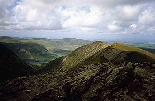
Whiteside is a fell in the north-western area of the English Lake District. It stands at the western end of the Grisedale Pike- Hopegill Head ridge overlooking Crummock Water.

Birks is a fell in the English Lake District situated two kilometres south west of the village of Patterdale in the Eastern Fells. The fells summit sits on a shoulder of the north east ridge of the higher and better known fell of St Sunday Crag, by which it is dominated, walkers often pass over the top of Birks either climbing or descending from the larger fell. The fell's name means a place where Birch trees predominate.
Crib-y-rhiw is a top of Y Llethr and a ridge in the Rhinogydd of Snowdonia, north Wales. The summit straddles a thin ridge connecting Y Llethr to Diffwys.

Gau Graig is a subsidiary summit of Cadair Idris in the Snowdonia National Park, in Gwynedd, northwest Wales. It lies to the east of Mynydd Moel on a broad grassy plateau. It marks the eastern end of the Cadair Idris ridge.

Bimberi Peak or Mount Bimberi with an elevation of 1,913 metres (6,276 ft) located within the Brindabella Ranges is the highest mountain in the Australian Capital Territory (ACT). It is located on the border between New South Wales (NSW) and the ACT, the NSW portion in Kosciuszko National Park and the ACT portion in Namadgi National Park. It is accessible by bush walking trails and requires no specialised climbing skills, although there is no marked trail to the very summit.

Llais Gwynedd is a small regionalist political party based in Gwynedd in North Wales. The party formed following the Plaid Cymru executive's proposal to more than halve the number of primary schools in Gwynedd by closing rural schools. Many of the party's members are former members of Plaid. The campaign was founded as Llais y Bobl, or "People's Voice", but the name was changed because of another party by that name in Blaenau Gwent.

Mount Hay, a mountain that is part of the Mt Hay Range of the Blue Mountains Range which is a spur off the Great Dividing Range, is located in the Blue Mountains National Park, New South Wales, Australia. It is located approximately 100 kilometres (62 mi) west of Sydney and 10 kilometres (6.2 mi) north of the nearest town, Wentworth Falls. Mount Hay is approximately 944 metres (3,097 ft) AMSL and is one of several basalt caps located within the UNESCO World Heritage Greater Blue Mountains Area.
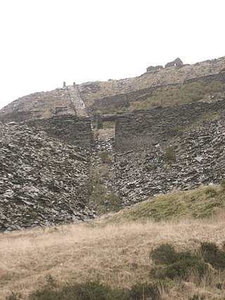
Votty & Bowydd quarry is a major slate quarry in the town of Blaenau Ffestiniog, North Wales. It was one of the major users of the Ffestiniog Railway. It opened in 1870 In the quarry's peak years around 1900, the quarry produced around 17,000 tons-per-annum of slate, employing 500 men. It continues to produce crushed slate on a limited scale under the ownership of the nearby Llechwedd quarry.

Diphwys Casson quarry was a major slate quarry in the town of Blaenau Ffestiniog, Gwynedd, North Wales. It was one of the major users of the Ffestiniog Railway.

