The Afon Ysgethin is a short river in Gwynedd, Wales. Flowing entirely within Snowdonia National Park, it rises beneath the peaks of Y Llethr and Diffwys in the Rhinogydd mountain range and runs in a generally WSW direction towards Cardigan Bay. Its upper reaches are crossed by two old stone bridges: Pont Scethin and Pont Fadog. Below the latter, the river flows through the Cors y Gedol woodland, a temperate rain forest with a diverse flora and fauna.
West of the ridge connecting Y Llethr and Diffwys, headwater streams flow into a small upper lake, Llyn Dulyn, and Llyn Bodlyn reservoir. Originally a natural lake, Llyn Bodlyn was enlarged in 1894 to provide Barmouth with water.[1]
The river emerging from the reservoir is crossed by a historic track at Pont Scethin. This old stone arch bridge ("probably 18th century") was used by packhorses and drovers on a once important route leading from Harlech to London.[2] The scheduled monument is of national importance "for its potential to enhance our knowledge of post-medieval transport techniques". Its single arch is relatively high: The bridge was built so the usually small river could be crossed even when flooding. The footway is just under two metres wide at the narrowest point. The low parapets (circa 50cm high) consist of large, elongated blocks of stone, which must have been quite difficult to transport.[3]
Looking down on Llyn Bodlyn and Afon Ysgethin from the historic track
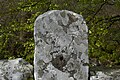
A further 3km downstream, the river is crossed by Pont Fadog. This Grade II listed roadbridge is on the original medieval drovers' route to Bontddu and Dolgellau. It is built of rubble masonry, with a single segmental arch and low parapet walls.[4]
At the apex of the arch, an inscription on a stone tablet states that the bridge was improved in 1762 by a mason called H. Edward, who was commissioned by William Vaughan.[4] Vaughan was a member of the powerful owner family of nearby Cors y Gedol Hall (see Dyffryn Ardudwy).
WV 1762 H Ed SAER ('mason')
Coed Cors y Gedol
Coed Cors y Gedol, a temperate rain forestIts flora includes over 90 species of mosses and liverworts
However, some parts of the woodland need management to become more diverse, and there are too many non-native beech trees, which are to be replaced by native trees such as oak and hazel.[6][7]
Tal-y-bont
After traversing Coed Cors y Gedol, circa 2km from Pont Fadog, the river flows past the village of Tal-y-bont. Near the "Ysgethin Inn", which was once a fulling mill,[8] it is crossed by a rather narrow bridge carrying the A496 road; a further 500m downstream, by the Cambrian Coast railway. After another 1200m, the Afon Ysgethin flows into Cardigan Bay.[9]
The "Ysgethin Inn" was once a fulling mill
Narrow "Pont Talybont", carrying the A496 road
Railway bridge over Afon Ysgethin, close to the coast
References
↑Roberts, Geraint. The Lakes of Eryri. Llanrwst: Carreg Gwalch, 1995.
This page is based on this Wikipedia article Text is available under the CC BY-SA 4.0 license; additional terms may apply. Images, videos and audio are available under their respective licenses.