
Snowdonia, or Eryri, is a mountainous region and national park in northwestern Wales. It contains all 15 mountains in Wales over 3000 feet high, including the country's highest, Snowdon, which is 1,085 metres (3,560 ft) tall. These peaks are all part of the Snowdon, Glyderau, and Carneddau ranges in the north of the region. The shorter Moelwynion and Moel Hebog ranges lie immediately to the south.

The Berwyn range is an isolated and sparsely populated area of moorland in the northeast of Wales, roughly bounded by Llangollen in the northeast, Corwen in the northwest, Bala in the southwest, and Oswestry in the southeast.
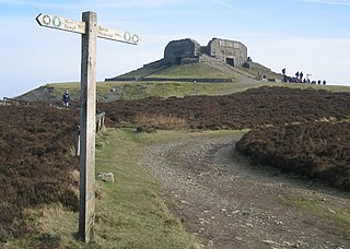
Moel Famau is the highest hill in the Clwydian Range and the highest point of the county of Flintshire in Wales. It lies on the boundary between Denbighshire and Flintshire. The hill, which also gives its name to the Moel Famau country park, has been classed as an Area of Outstanding Natural Beauty since 1985. It is also surrounded by several well-preserved Iron Age hill forts. It is also the third-highest peak in the extended AONB of the Clwydian Range and Dee Valley.

Moel Hebog is a mountain in Snowdonia, north Wales which dominates the view west from the village of Beddgelert. It gives name to a whole range of peaks in the north-western corner of Snowdonia, which include the Nantlle Ridge and Mynydd Mawr.
Cadair Berwyn, Cader Berwyn or Craig Uchaf is a mountain summit in north-east Wales with a height of 832 metres (2,730 ft) above sea level. It is the highest point in the Berwyn range, the highest in North East Wales and the highest significant summit in Wales outside the National Parks. Cadair Berwyn and Foel Cedig to the west are the two Marilyns that form the Berwyn range. The undulating plateau of the range also includes a large number of other summits above 2,000 feet (610 m), including satellite summits of Cadair Berwyn and many which are classed as Nuttalls.

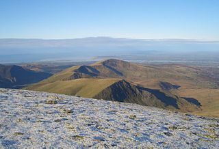
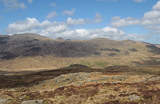
Arenig Fawr is a mountain in Snowdonia, North Wales, close to Llyn Celyn reservoir, alongside the A4212 between Trawsfynydd and Bala.

Foel Fenlli or Moel Fenlli is a hill in Denbighshire, North Wales. With a summit at an elevation of 511 metres (1,677 ft), it is the second highest peak of the Clwydian Range.
Moel Cynghorion is a mountain in Snowdonia, North Wales. It lies two miles north-west of Snowdon, and forms part of the Moel Eilio Horseshoe walk. The summit is situated on a wide plateau, marked by a pile of stones. The southern slopes are gentle, while the northern aspect is precipitous. The summit has close views of Clogwyn Du'r Arddu and Snowdon. Views from the summit can extend as far as Holyhead in Anglesey to nearby towns and villages in Gwynedd such as Caernarfon, Llanrug and Llanberis. On a clear day the Wicklow Mountains in Ireland can be seen across the Irish Sea, at a distance of approximately 80 miles.

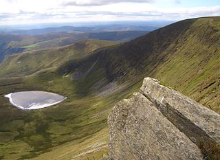
Rhinog Fawr is a mountain in Snowdonia, North Wales and forms part of the Rhinogydd range. It is the third highest summit of the Rhinogydd, losing out to Y Llethr and Diffwys respectively. Its smaller cousin Rhinog Fach lies to the south, separated by the pass of Bwlch Drws Ardudwy, while its other neighbour, Moel Ysgyfarnogod lies to the north.
Moel Sych with a height of 826.7 metres (2,712 ft) is a subsidiary summit of Cadair Berwyn in north east Wales. It is the third highest summit in the Berwyn range after Cadair Berwyn and Cadair Berwyn North Top.
Foel Penolau is a mountain close to Moel Ysgyfarnogod in Snowdonia, North Wales and is the northernmost summit of the Rhinogydd, and overlooks Llyn Trawsfynydd. From the summit it is possible to see the towns of Porthmadog and Blaenau Ffestiniog. As a result of a revised survey of its topographical prominence, Foel Penolau gained Hewitt and Simms status in December 2018 when its prominence was measured to be above 30 m (98 ft).

Mynydd Moel is the second highest summit of Cadair Idris in the Snowdonia National Park, in Gwynedd, northwest Wales.

Moel Lefn is a summit in Snowdonia. It is a subsidiary peak of Moel Hebog and a sister peak of Moel yr Ogof. Its summit marks the end of the Hebog ridge.
Y Foel Goch is a mountain in Snowdonia, north-west Wales, and is a sister peak along with Gallt yr Ogof to Glyder Fach. Between Glyder Fach and its summit lies Llyn Caseg-fraith, a popular lake for photographing Tryfan and its reflection.

Arenig Fach is a mountain in southern Snowdonia, north Wales. It is a peak in the Arenig range and lies to the north of its parent peak Arenig Fawr.

Moel Llyfnant is a mountain in the southern portion of the Snowdonia National Park in Gwynedd, Wales. It is a peak in the Arenig mountain range. It lies to the west of Arenig Fawr. It has one notable top, the twin peaked Gallt y Daren, being at the end of its west ridge.

Arenig Fawr South Ridge Top is a top of Arenig Fawr in southern Snowdonia, North Wales. It lies in area of rocky knolls and small tarns, found on the broad south ridge of Arenig Fawr.

Bryn Cader Faner is a Bronze Age round cairn which lies to the east of the small hamlet of Talsarnau in the Ardudwy area of Gwynedd in Wales. The diameter is 8.7 metres (29 ft) and there are 18 thin jagged pillars which jut upwards from the low cairn. It is thought to date back to the late third millennium BC. The site was disturbed by 19th-century treasure hunters, who left a hole in the centre, indicating the position of a cist or a grave. Originally there may have been about 30 pillars, each some 2 metres (7 ft) long. However, before the Second World War, the British Army used the site for gunnery practice. The Army damaged many of the stones on the east side.

Moel y Gest is a 263 m (863 ft) hill to the west of Porthmadog in North Wales. It is a very rocky hill with high topographic prominence because of the lower land that surrounds it on all sides, and qualifies as a Marilyn. The views from the top are far ranging and include the Llŷn Peninsula, the Rhinogydd, Moelwynion, Moel Hebog, and Snowdon.


