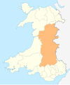
Until 1974, Montgomeryshire was an administrative county in mid Wales, later classed as one of the thirteen historic counties of Wales. It was named after its county town, Montgomery, which in turn was named after one of William the Conqueror's main counsellors, Roger de Montgomerie, who was the 1st Earl of Shrewsbury.
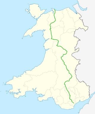
The A470 is a trunk road in Wales. It is the country's longest road at 186 miles (299 km) and links the capital Cardiff on the south coast to Llandudno on the north coast. While previously one had to navigate the narrow roads of Llanidloes and Dolgellau, both these market towns are now bypassed due to extensive road modernisation. The 26 miles (42 km) from Cardiff Bay to Merthyr Tydfil are mainly dual carriageway, but most of the route from north of Merthyr to Llandudno is single carriageway.

Newtown is a town in Powys, Wales. It lies on the River Severn in the community of Newtown and Llanllwchaiarn, within the historic boundaries of Montgomeryshire. It was designated a new town in 1967 and saw population growth as firms settled, changing its market town character. Its 2001 population of 10,780 rose to 11,357 in the 2011 census, and rose again to 11,362 in the 2021 census.
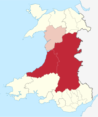
Mid Wales, or Central Wales, is a region of Wales, encompassing its midlands, in-between North Wales and South Wales. The Mid Wales Regional Committee of the Senedd covered the unitary authority areas of Ceredigion and Powys and the area of Gwynedd that had previously been the district of Meirionnydd. A similar definition is used by the BBC. The Wales Spatial Plan defines a region known as "Central Wales" which covers Ceredigion and Powys.

The A458 is a route on the UK highway network that runs from Mallwyd, near Machynlleth, in Wales, merging with the A456 Hagley Road and the Quinton Expressway on the outskirts of Birmingham, in England. On the way it passes through Welshpool, Shrewsbury, Much Wenlock, Bridgnorth, Stourbridge and Halesowen
The Central Wales Football League(formerly the Mid Wales Football League) is a football league in Wales at tier four of the Welsh Football pyramid, run by the Central Wales Football Association. The league consists of two regionally based divisions - a Northern Division and a Southern Division. The league offers a promotion route to the Football Association of Wales administered tier three Ardal Leagues. Relegation is possible to the relevant tier five level leagues in Aberystwyth, Ceredigion and Montgomeryshire.
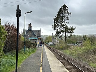
Caersws railway station is on the Cambrian Line in mid-Wales, serving the village of Caersws. It is notable in that there are 22 miles (35 km) separating this station and Machynlleth, the longest distance between two intermediate stations in Wales.

The River Dyfi, also known as the River Dovey, is an approximately 30-mile (48-kilometre) long river in Wales.

The District of Montgomeryshire or Montgomery was one of three local government districts of the county of Powys, Wales, from 1974 until 1996. The district had an identical area to the previous administrative county of Montgomeryshire. The district was abolished in 1996, with Powys County Council taking over its functions.
Cemmaes Road is a village in Powys, Wales. It is in the community of Glantwymyn.
The SY postcode area, also known as the Shrewsbury postcode area, is a group of 25 postcode districts in the West Midlands and Mid Wales, with small areas in North West England and North Wales. Together the districts cover most of Shropshire, north Powys, north Ceredigion, and part of south Cheshire. In addition, the SY7 and SY8 districts cover a small part of north Herefordshire, and the SY14 and SY20 districts also contain very small parts of Gwynedd and Wrexham County Borough respectively. The postcode area contains 32 post towns.

The River Onny is a river in Shropshire, England. It is a major tributary of the River Teme.

Penegoes is a village in Powys, Wales, between Cemmaes Road and Machynlleth, on the A489 road, and the primary settlement of the community of Cadfarch.
The Llanidloes and Newtown Railway (L&NR) was a railway company between Llanidloes and Newtown in Montgomeryshire, Wales. It was promoted locally when plans for trunk railways passing through the locality were cancelled; local people saw that a railway connection was essential to the flannel industry in the district. The 17-mile (27 km) line opened in 1859, and at first was isolated from any other railway, but from 1861 it became connected to Oswestry by an allied railway company, and other companies also connected to it. From 1864 the company was incorporated into the new Cambrian Railways company.

Carno is a closed railway station in Carno, on the Cambrian Line, that was part of the Newtown and Machynlleth Railway. The station was closed in 1965 as part of the Beeching Cuts though there are proposals to re-open it.

Cemmes Road was a railway station on the Newtown and Machynlleth Railway (N&MR) in Mid-Wales, serving the village of Cemmaes Road.

Moat Lane Junction was a railway junction in Montgomeryshire near to the village of Caersws in mid-Wales. It was the junction where the Newtown and Machynlleth Railway opened in 1863 diverged from the Llanidloes and Newtown Railway which opened four years earlier. Although having only three through platforms, by rural standards it was a busy interchange station and in its heyday possessed a refreshment room.
The Newtown and Machynlleth Railway was a railway company in Wales. It built a line from a junction with the Llanidloes and Newtown Railway near Caersws to the market town of Machynlleth; the line opened in 1862. Newtown had become the hub of railway lines in the district. Machynlleth was an important town, and extension from there to Aberystwyth and to the coast northward was in the minds of the promoters.
Glanmule is a small village in the north of Powys, Wales. It is located in Montgomeryshire, approximately 2.5 miles to the east of Newtown. It stands at the junction of the B4368 and A489 roads, two miles from the Welsh-English border.