Route
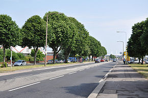
The route begins at traffic lights with the A4161 Newport Road and West Grove, in the city centre of Cardiff. It heads south along the dual-carriageway Fitzalan Place, before turning west along Adam Street, where the A4160 meets the A4234 Central Link. The road turns left onto Bute Street, to turn right at Callaghan Square, where it runs concurrent with the A470 for around 200 yards (180 m), before reaching a roundabout. Here we continue straight onto Tresillian Way, whilst the A470 turns right onto St Mary's Way. As Tresillian Way, we pass Cardiff Central Station, before becoming Penarth Road, continuing in a south-westerly direction. It crosses through the Penarth Road commercial district then crosses the River Taff, before entering a residential area, where we meet the A4119. We continue to follow Penarth Road, which becomes a local high street, before reaching Grangetown station overhead and an industrial estate. Then, the A4160 passes over the River Ely, before immediately afterwards passing under the A4232 Grangetown Link (with no junction), after which it turns to a south easterly direction. It meets the A4055 at a crossroads, where it becomes Cogan Hill briefly, to pass Cogan station and retail park, before changing its name to Windsor Road. Windsor Road passes two railway stations; Dingle Road station and Penarth station in the town centre of Penarth.

Cardiff Bay is an area and freshwater lake in Cardiff, Wales. The site of a former tidal bay and estuary, it serves as the river mouth of the River Taff and Ely. The body of water was converted into a 500-acre (2.0 km2) lake as part of a UK Government redevelopment project, involving the damming of the rivers by the Cardiff Bay Barrage in 1999. The barrage impounds the rivers from the Severn Estuary, providing flood defence and the creation of a permanent non-tidal high water lake with limited access to the sea, serving as a core feature of the redevelopment of the area in the 1990s.

The A470 is a trunk road in Wales. It is the country's longest road at 186 miles (299 km) and links the capital Cardiff on the south coast to Llandudno on the north coast. While previously one had to navigate the narrow roads of Llanidloes and Dolgellau, both these market towns are now bypassed due to extensive road modernisation. The 26 miles (42 km) from Cardiff Bay to Merthyr Tydfil are mainly dual carriageway, but most of the route from north of Merthyr to Llandudno is single carriageway.

Penarth is a town and community in the Vale of Glamorgan, Wales, approximately 4 miles (6.4 km) south of Cardiff city centre on the north shore of the Severn Estuary at the southern end of Cardiff Bay.

Butetown is a district and community in the south of the city of Cardiff, the capital of Wales. It was originally a model housing estate built in the early 19th century by The 2nd Marquess of Bute, for whose title the area was named. Commonly known as "Tiger Bay", this area became one of the UK's first multicultural communities with people from over 50 countries settled here by the outbreak of the First World War, working in the docks and allied industries. Some of the largest communities included the Somalis, Yemenis and Greeks, whose influence still lives on today. A Greek Orthodox church still stands at the top of Bute Street. It is known as one of the "five towns of Cardiff", the others being Crockherbtown, Grangetown, Newtown and Temperance Town. The population of the ward and community taken at the 2011 census was 10,125. It is estimated that the Butetown's population increased to 14,094 by 2019.

The Taff Trail is a popular walking and cycle path that runs for 55 miles (89 km) between Cardiff Bay and Brecon in Wales. It is so named because it follows the course of the River Taff. Along much of its length, it follows the National Cycle Network Route 8 that continues to Holyhead, and is substantially off-road.

Cardiff city centre is the city centre and central business district of Cardiff, Wales. The area is tightly bound by the River Taff to the west, the Civic Centre to the north and railway lines and two railway stations – Central and Queen Street – to the south and east respectively. Cardiff became a city in 1905.

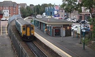
Grangetown railway station is a railway station serving the Grangetown district of Cardiff, Wales. It is located on the Vale of Glamorgan Line 1 mile (1.5 km) south west of Cardiff Central towards Bridgend via Barry, Penarth and Barry Island.
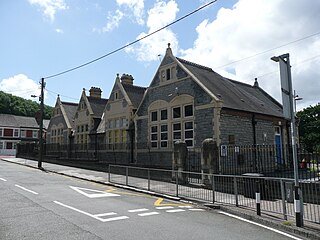
Penarth railway station is the railway station serving the town of Penarth in the Vale of Glamorgan, South Wales. It is the terminus of Network Rail's Penarth branch running from Cogan Junction to Penarth station, 1 mile 12 chains from the junction and 2 miles 67 chains south of Cardiff Central station. The Penarth branch ran from Cogan Junction to Biglis Junction, a rail mileage of 5 miles 65 chains and was officially closed beyond Penarth after the last passenger train ran on Saturday 4 May 1968.
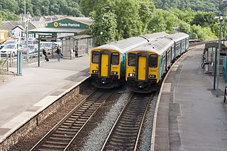
Cogan railway station is a railway station serving Cogan in the Vale of Glamorgan, Wales. It is on the Vale of Glamorgan Line 2+3⁄4 miles (4.4 km) south of Cardiff Central on the way to Barry Island and Bridgend.

Grangetown is a district and community in the south of Cardiff, capital of Wales. It is one of the largest districts in the south of the city and is bordered by Riverside, Canton and Butetown. The River Taff winds its way through the area. Adjacent to the city's Cardiff Bay area, Grangetown is experiencing a period of gentrification and improvements in its infrastructure. Its population as of 2011 was 19,385 in 8,261 households. One of the "five towns of Cardiff", the others are Butetown, Crockherbtown, Newtown and Temperance Town.
Cogan is a suburb of Penarth in the Vale of Glamorgan, Wales 3 miles (5 km) south of the centre of the Welsh capital city of Cardiff. Cogan contains one of the vale's four major leisure centres.
Transport in Cardiff, capital and most populous city in Wales involves road, rail, bus, water and air. It is a major city of the United Kingdom and a centre of employment, government, retail, business, culture, media, sport and higher education.

The A4232, which is also known either as the Peripheral Distributor Road (PDR) or the Cardiff Link Road, is a distributor road in Cardiff, the capital of Wales.

The A4055 is the main road link between Cardiff Bay and Barry.

Cardiff International Sports Village is located in Cardiff Bay in the city of Cardiff, Wales. It is one of the largest regeneration projects currently in the UK and is a public-private funded project.

Cycling in Cardiff, capital of Wales, is facilitated by its easy gradients and large parks. In the mid-2000s between 2.7% and 4.3% of people commuted to work by cycling in the city. In 2017 12.4% of workers cycled to work at least 5 days a week. However, cyclists in the city are deterred from cycling by poor facilities and aggressive traffic, according to research by Cardiff University.
Rail transport in Cardiff has developed to provide connections to many other major cities in the United Kingdom, and to provide an urban rail network for the city and its commuter towns in southeast Wales. Today, there are three train operating companies in Cardiff: Great Western Railway, CrossCountry and Transport for Wales.

Harriet Windsor-Clive, Baroness Windsor was a landowner and wealthy benefactor in the Penarth and Cardiff area of South Wales. She is probably best known for developing Penarth Dock in competition with the Marquess of Bute's docks in Cardiff and for her charitable donations in the area. A daughter of the 5th Earl of Plymouth, she was granted the title 13th Baroness Windsor in 1855 after the deaths of her sister and brother.

National Cycle Route 88 is a route of the National Cycle Network, running from Newport to its planned finish site at Margam.