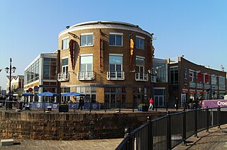
Lloyd George Avenue looking northLloyd George Avenue looking south towards the Wales Millennium CentreLloyd George Avenue development won for its contractors Norwest Holst, the Arts & Business Cymru Award for Best Sponsor of New Work in 2001
Lloyd George Avenue (Welsh: Rhodfa Lloyd George), originally known as Bute Avenue, is an avenue in Cardiff, Wales. Roughly one mile long, the road links the Inner Harbour of Cardiff Bay to Cardiff city centre and forms part of the A470 road. It runs parallel to Bute Street and the Butetown Branch Line. Landscaping on the route was completed in 2000, and it was renamed after the Liberal prime minister David Lloyd George. The site of the avenue had been known as Collingdon Road, which was described as a "grimy industrial area of small factories and workshops, employing hundreds of people".[1]
The original concept, a scheme by Cardiff Bay Development Corporation (CBDC), envisaged the removal of the railway line along Bute Street to create a continental-style boulevard, initially named Bute Avenue, with a Light Rapid Transit system, a park and recreational facilities. The Welsh Office required the CDBC to use the Private Finance Initiative to construct Bute Avenue. Due to high costs, the LRT element of the project was abandoned, but a new road was built as part of a £120 million PFI scheme[2][3] awarded to a consortium of investors and shareholders named City Link.[4] After the wind-up of the CBDC in March 2000, all property rights and liabilities for the Bute Avenue project transferred to the Welsh Development Agency.
In 2011 the Welsh Government revealed that the full cost of the PFI scheme, including its 25-year payback period, would be £188.8 million. This includes the 350 neighbouring homes, some shops, commercial development and a small section of new road surrounding Callaghan Square.[4] Responsibility for ongoing maintenance reverts to Cardiff Council in 2025.[4]
Although officials from the Welsh Development Agency and the City and County of Cardiff have examined various options for the completion of the original boulevard scheme,[5] as of 2011 no progress has been made.
Notes
↑ Mortimer, Dic (28 January 2018). "Cardiff Bay (including Butetown)". Cardiff The Biography. Amberley Publishing. ISBN9781445642512.
Tiger Bay was the local name for an area of Cardiff which covered Butetown and Cardiff Docks. Following the building of the Cardiff Barrage, which dams the tidal rivers, Ely and Taff, to create a body of water, it is referred to as Cardiff Bay. Tiger Bay is Wales’ oldest multi-ethnic community, with sailors and workers from over 50 countries settling there from the mid-19th century onwards.
Cardiff Bay is an area and freshwater lake in Cardiff, Wales. The site of a former tidal bay and estuary, it serves as the river mouth of the River Taff and Ely. The body of water was converted into a 500-acre (2.0 km2) lake as part of a UK Government redevelopment project, involving the damming of the rivers by the Cardiff Bay Barrage in 1999. The barrage impounds the rivers from the Severn Estuary, providing flood defence and the creation of a permanent non-tidal high water lake with limited access to the sea, serving as a core feature of the redevelopment of the area in the 1990s.
Butetown is a district and community in the south of the city of Cardiff, the capital of Wales. It was originally a model housing estate built in the early 19th century by the 2nd Marquess of Bute, for whose title the area was named. Commonly known as "Tiger Bay", this area became one of the UK's first multicultural communities with people from over 50 countries settled here by the outbreak of the First World War, working in the docks and allied industries. Some of the largest communities included the Somalis, Yemenis and Greeks, whose influence still lives on today. A Greek Orthodox church still stands at the top of Bute Street. It is known as one of the "five towns of Cardiff", the others being Crockherbtown, Grangetown, Newtown and Temperance Town. The population of the ward and community taken at the 2011 census was 10,125. It is estimated that the Butetown's population increased to 14,094 by 2019.
Atlantic Wharf is a southern area of the city of Cardiff, Wales. It is primarily an area of new houses and apartments located on the west side of the disused Bute East Dock and to the east of Lloyd George Avenue. It also includes a number of refurbished dock warehouses, modern hotels, the Red Dragon Centre and Cardiff Council's County Hall. Atlantic Wharf lies in the Butetown electoral division of Cardiff and the Cardiff South and Penarth constituency for the UK Parliament and the Senedd.
Cardiff city centre is the city centre and central business district of Cardiff, Wales. The area is tightly bound by the River Taff to the west, the Civic Centre to the north and railway lines and two railway stations – Central and Queen Street – to the south and east respectively. Cardiff became a city in 1905.
Cardiff Bay railway station, formerly Cardiff Bute Road, is a station serving the Cardiff Bay and Butetown areas of Cardiff, Wales. It is the southern terminus of the Butetown branch line 1 mile (1.5 km) south of Cardiff Queen Street.
The A4232, which is also known either as the Peripheral Distributor Road (PDR) (Welsh: Ffordd Ddosbarthu Ymylol) or the Cardiff Link Road (Welsh: Ffordd Gyswllt Caerdydd), is a distributor road in Cardiff, the capital of Wales.
Bute Street is a street in Cardiff, Wales. It links Cardiff Bay and Butetown with Cardiff city centre. It now has no road number. It runs from the dockside of the Mermaid Quay complex in the south, which is now a pedestrian zone, to the junction of Bute Terrace (A4160) in the north.
The Pierhead Building is a Grade I listed building in Cardiff Bay, Wales. One of Cardiff's most familiar landmarks, it was built in 1897 as the headquarters for the Bute Dock Company.
Mermaid Quay is a waterfront shopping and leisure district in the Cardiff Bay area of Cardiff, Wales. The 14,000 m2 (150,000 sq ft) development was opened in 1999, and includes restaurants, bars, cafes and shops.
The timeline of Cardiff history shows the significant events in the history of Cardiff which transformed it from a small Roman fort into the modern capital city of Wales.
Architecture in Cardiff, the capital city of Wales, dates from Norman times to the present day. Its urban fabric is largely Victorian and later, reflecting Cardiff's rise to prosperity as a major coal port in the 19th century. No single building style is associated with Cardiff, but the city centre retains several 19th and early 20th century shopping arcades.
Cycling in Cardiff, capital of Wales, is facilitated by its easy gradients and large parks. In the mid-2000s between 2.7% and 4.3% of people commuted to work by cycling in the city. In 2017 12.4% of workers cycled to work at least 5 days a week. However, cyclists in the city are deterred from cycling by poor facilities and aggressive traffic, according to research by Cardiff University.
The Craft in the Bay Gallery is an exhibition and craft retail area located at the south end of Lloyd George Avenue, Cardiff Bay. It was designed by the architect Chris Elford. It is operated by a charitable arts organisation, The Makers Guild in Wales. The gallery is opposite the Wales Millennium Centre and close to the Senedd building. The building consists of the relocated and refurbished Grade II listed “D” Shed, previously an industrial warehouse located next to Bute East Dock.
St Mary's Church was an Anglican church in Cardiff, Wales, which stood at the south end of the current St. Mary's Street, from 1107 until 1620. After severe flood damage it was abandoned in 1701 and later replaced at a different location in 1843.
Callaghan Square is a large public plaza in Cardiff, Wales, previously known as Bute Square. It was developed as part of a Private Finance Initiative (PFI) scheme to link central Cardiff with Cardiff Bay.
Mount Stuart Square is a residential and commercial square in Cardiff, Wales. It is located in the Butetown area of the city. Originally developed in the late 1800s as a residential location for nearby dock workers, it quickly became a centre for upscale residential properties which revolved around the main square. By 1900, commercial activity had taken its place, dominated by the Coal Exchange, which occupied the once open central space. The square contains a high concentration of listed buildings, which represent a range of architectural styles and some of Cardiff's finest examples of late 19th and early 20th century commercial architecture. Mount Stuart Square area was designated a Conservation Area in July 1980.
A statue of the Second Marquess of Bute stands in Callaghan Square, Cardiff, Wales in recognition of John Crichton-Stuart who developed Cardiff Docks. The statue was originally unveiled in 1853. It was designed by J. Evan Thomas.
This page is based on this Wikipedia article Text is available under the CC BY-SA 4.0 license; additional terms may apply. Images, videos and audio are available under their respective licenses.