
Thornhill is a community in the north of the city of Cardiff, Wales. It lies south of Caerphilly.

Llantwit Major is a town and community in Wales on the Bristol Channel coast. It is one of four towns in the Vale of Glamorgan, with the third largest population after Barry and Penarth, and ahead of Cowbridge. It is 4+1⁄2 miles (7.2 km) from Cowbridge, 9 miles (14 km) from Bridgend, 10 miles (16 km) from Barry, and 15 miles (24 km) from Cardiff. It had a population of 9,530 in 2021.
Pontcanna is an inner-city district and community in the west of Cardiff, Wales. It is located adjecent to Canton, Cardiff. It is also located a short distance to the city centre, and its borders are approximately indicated by Western Avenue, the River Taff, Cowbridge Road East and Llandaff Road.

The Taff Trail is a walking and cycle path that runs for 55 miles (89 km) between Cardiff Bay and Brecon in Wales. It is so named because it follows the course of the River Taff. Along much of its length, it follows the National Cycle Network Route 8 that continues to Holyhead, and is substantially off-road.

Riverside is an inner-city area and community of Cardiff, Wales, next to the River Taff. Riverside is also the name of the electoral ward, which includes the district of Pontcanna, to the north. The population of the community in 2011 was 13,771. Pontcanna was removed from the community in 2016.
Canton is an inner-city district and community in the west of Cardiff, capital of Wales, lying 2 miles (3.2 km) west of the city's civic centre. It is located adjacent to Pontcanna. Canton is one of the most ethnically diverse of Cardiff's suburbs, with a significant Pakistani and Indian population. The total population of Canton increased to 14,304 at the 2011 census. It is also the most Welsh-speaking district of central Cardiff, with 19.1% of the population speaking Welsh.
Gwynllŵg was a kingdom of mediaeval Wales and later a Norman lordship and then a cantref.
Rumney is a district and community in the east of the city of Cardiff, Wales. It lies east of the Rhymney River, and was historically part of Monmouthshire. On 1 April 1938 the Cardiff Extension Act 1937 incorporated it into the county borough of Cardiff, although it became part of Glamorganshire in the 1880's.

Llandaff North is a district, community and coterminous electoral ward in the north of Cardiff, the capital city of Wales.

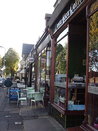
Cowbridge Road East is a major road in western-central Cardiff, the capital of Wales. It is the principal road which passes through the busy district of Riverside and Canton and connects Cowbridge Road West in the western districts to central Cardiff. The road is partly on the A4161. It is eventually crossed by Cathedral Road towards the city centre. It is home to numerous shops, pubs and restaurants.
Cardiff Corinthians F.C. are a football club from Cardiff, Wales. The club plays in the Ardal SW League.

The A4232, which is also known either as the Peripheral Distributor Road (PDR) (Welsh: Ffordd Ddosbarthu Ymylol) or the Cardiff Link Road (Welsh: Ffordd Gyswllt Caerdydd), is a distributor road in Cardiff, the capital of Wales.

The Cathays electoral ward of Cardiff, created in 1890, which since 1974 has covered the Cathays and Castle communities. There is no community council for the area and it has elected four councillors since 1999.
Ysgol Gyfun Gymraeg Plasmawr is a Welsh-medium comprehensive secondary school in Cardiff. It opened in September 1998 as the second school of its kind in Cardiff. Its buildings had formerly belonged to Waterhall Secondary Modern School and more recently formed Ysgol Gyfun Gymraeg Glantaf's Lower School. The current headteacher is Dr Rhodri Thomas.

The A4226 is a main road linking Bonvilston to Barry and Cardiff International Airport (CIA) in the Vale of Glamorgan, Wales.

Pontcanna Fields & Llandaff Fields are two urban green spaces that adjoin each other in Cardiff, Wales, covering 157 acres (64 ha) and 70 acres (28 ha) respectively. They are situated on the western banks of the River Taff and to the east of Llandaff and northeast of Pontcanna. Both parks are owned by Cardiff Council and managed by its Parks department. The parks are mostly on flat ground as they form part of the floodplain of the River Taff, although the ground does rise on the western edge of Llandaff Fields. To the south of Pontcanna Fields lies Sophia Gardens and the Sophia Gardens cricket ground. The parkland is lined with avenues of trees and large grassed areas. The park is also used for sporting events.

Ysgol Gymraeg Pwll Coch is a large Welsh-medium primary school in the Canton area of western Cardiff, in Wales.
Pwll-coch is an area part of the district of Canton in Cardiff, Wales. It was formerly a separate hamlet in the parish of Llandaff near Cardiff. It was located on the junction of Windway Road and the main road from Cardiff to Ely, a short distance from Ely Bridge.

Plasdŵr is a planned new suburb of approximately 7,000 homes in the north of Cardiff, Wales. Construction by lead developer Redrow Homes started in 2017.

The Riverside electoral ward of Cardiff covers the Riverside and Pontcanna areas of the city, electing three councillors to Cardiff Council. The ward was originally created in 1890, as a ward to Cardiff County Borough Council.

