Carmarthenshire is a county in the south-west of Wales. The three largest towns are Llanelli, Carmarthen and Ammanford. Carmarthen is the county town and administrative centre. The county is known as the "Garden of Wales" and is also home to the National Botanic Garden of Wales.

The M4, originally the London-South Wales Motorway, is a motorway in the United Kingdom running from west London to southwest Wales. The English section to the Severn Bridge was constructed between 1961 and 1971; the Welsh element was largely complete by 1980, though a non-motorway section around Briton Ferry bridge remained until 1993. On the opening of the Second Severn Crossing in 1996, the M4 was rerouted over it.

The A34 is a major road in England. It runs from the A33 and M3 at Winchester in Hampshire, to the A6 and A6042 in Salford, close to Manchester City Centre. It forms a large part of the major trunk route from Southampton, via Oxford, to Birmingham, The Potteries and Manchester. For most of its length, it forms part of the former Winchester–Preston Trunk Road. Improvements to the section of road forming the Newbury Bypass around Newbury were the scene of significant direct action environmental protests in the 1990s. It is 151 miles (243 km) long.

The M56 motorway, serves the Cheshire and Greater Manchester areas of England. It runs east to west from junction 4 of the M60 at Gatley, south of Manchester, to Dunkirk, approximately four miles north of Chester. With a length of 33.3 miles (53.6 km), it connects North Wales and the Wirral peninsula with much of the rest of North West England, serves business and commuter traffic heading towards Manchester, particularly that from the wider Cheshire area, and provides the main road access to Manchester Airport from the national motorway network.

The A12 is a major road in Eastern England. It runs north-east/south-west between London and the coastal town of Lowestoft in the north-eastern corner of Suffolk, following a similar route to the Great Eastern Main Line until Ipswich. A section of the road between Lowestoft and Great Yarmouth became part of the A47 in 2017. Between the junctions with the M25 and the A14, the A12 forms part of the unsigned Euroroute E30. Unlike most A roads, this section of the A12, together with the A14 and the A55, has junction numbers as if it were a motorway.

The M53 is an 18.9-mile (30.4 km) motorway in the Metropolitan Borough of Wirral and Cheshire on the Wirral Peninsula in England. It is also referred to as the Mid Wirral Motorway. It runs between the Kingsway Tunnel, at Wallasey in the north, and the A55 at Chester.
The A483, officially described as the Swansea to Manchester Trunk Road, although now ending in Chester, is a major road in the United Kingdom. It runs from Swansea in Wales to Chester in England via Llandovery, Llandrindod Wells, Oswestry and Wrexham, a distance of around 153 miles (246 km).

The island of Ireland, comprising Northern Ireland and the Republic of Ireland, has an extensive network of tens of thousands of kilometres of public roads, usually surfaced. These roads have been developed and modernised over centuries, from trackways suitable only for walkers and horses, to surfaced roads including modern motorways. Driving is on the left-hand side of the road. The major routes were established before Irish independence and consequently take little cognisance of the border other than a change of identification number and street furniture. Northern Ireland has had motorways since 1962, and has a well-developed network of primary, secondary and local routes. The Republic started work on its motorway network in the early 1980s; and historically, the road network there was once somewhat less well developed. However, the Celtic Tiger economic boom and an influx of European Union structural funding, saw national roads and regional roads in the Republic come up to international standard quite quickly. In the mid-1990s, for example, the Republic went from having only a few short sections of motorway to a network of motorways, dual carriageways and other improvements on most major routes as part of a National Development Plan. Road construction in Northern Ireland now tends to proceed at a slower pace than in the Republic, although a number of important bypasses and upgrades to dual carriageway have recently been completed or are about to begin.

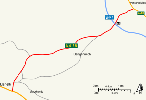
Llanelli is a market town and community in Carmarthenshire and the preserved county of Dyfed, Wales. It is located on the Loughor estuary and is the largest town in the county of Carmarthenshire. The town is 11 miles (18 km) north-west of Swansea and 12 miles (19 km) south-east of Carmarthen. The town had a population of 25,168 in 2011, estimated in 2019 at 26,225. The local authority was Llanelli Borough Council when the county of Dyfed existed, but it has been under Carmarthenshire County Council since 1996.

A trunk road, trunk highway, or strategic road is a major road, usually connecting two or more cities, ports, airports and other places, which is the recommended route for long-distance and freight traffic. Many trunk roads have segregated lanes in a dual carriageway, or are of motorway standard.

The M32 is a 4.4 miles (7.1 km) long motorway in South Gloucestershire and Bristol, England. It provides a link from the M4, a major motorway linking London and South Wales, to Bristol city centre and is maintained by National Highways, the national roads body.
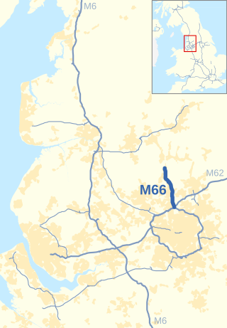
The M66, also known as the Bury Easterly Bypass, is a motorway in Lancashire and Greater Manchester, England. It is 8 miles (13 km) long and provides part of the route between the M62 and M60 motorways and the M65, with the rest being provided by the A56.
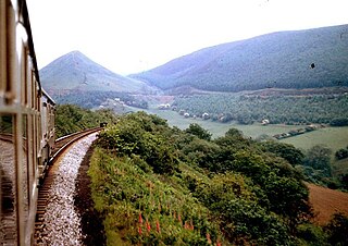
The Heart of Wales line is a railway line running from Craven Arms in Shropshire to Llanelli in southwest Wales. It serves a number of rural centres, including the nineteenth-century spa towns Llandrindod Wells, Llangammarch Wells and Llanwrtyd Wells. At Builth Road, two miles (3.3 km) from the town of Builth Wells, the line crosses the former route of the earlier Mid Wales Railway, which closed in the 1960s.

Pontarddulais, also known as Pontardulais, is both a community and a town in Swansea, Wales. It is 10 miles (16 km) northwest of the city centre. The Pontarddulais ward is part of the City and County of Swansea. Pontarddulais adjoins the village of Hendy in Carmarthenshire. The built-up population was 9,073.
Transport in Wales is heavily influenced by the country's geography. Wales is predominantly hilly or mountainous, and the main settlements lie on the coasts of north and south Wales, while mid Wales and west Wales are lightly populated. The main transport corridors are east–west routes, many continuing eastwards into England.

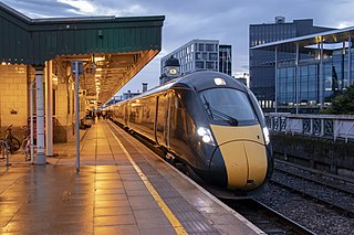
Pontarddulais railway station serves the town of Pontarddulais and village of Hendy in Swansea, Wales. The station is located at street level not far from the town centre and the Loughor estuary. All trains serving the station are operated by Transport for Wales.

The United Kingdom has a network of roads, of varied quality and capacity, totalling about 262,300 miles (422,100 km). Road distances are shown in miles or yards and UK speed limits are indicated in miles per hour (mph) or by the use of the national speed limit (NSL) symbol. Some vehicle categories have various lower maximum limits enforced by speed limiters. A unified numbering system is in place for Great Britain, whilst in Northern Ireland, there is no available explanation for the allocation of road numbers.
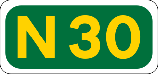
The N30 road is a national primary road in Ireland. It connects the N25 road and M11 motorway, providing a link running east-northeast through County Wexford, between New Ross and Enniscorthy. This provides for a more direct national route between the two towns, as the N25 and N11 both run to Wexford town, eastwards from New Ross and southwards from Enniscorthy respectively.

Pontlliw is a village in the community of Pontlliw and Tircoed, part of the City and County of Swansea in Wales. The village is located near Pontarddulais, off Junction 47 of the M4 motorway.

The M54 is a 23-mile (37 km) east-west motorway in the counties of Shropshire and Staffordshire, England. It is also referred to as the Telford motorway, after the road's primary westbound destination, the town of Telford. It cost £65 million to construct, and is two-lane dual carriageway for the majority of its length, with sections of three-lane.