Pontypridd is a town and a community in Rhondda Cynon Taf, Wales.

The A4 is a major road in England from Central London to Avonmouth via Heathrow Airport, Reading, Bath and Bristol. It is historically known as the Bath Road with newer sections including the Great West Road and Portway. The road was once the main route from London to Bath, Bristol and the west of England and formed, after the A40, the second main western artery from London.

Rhondda Cynon Taf is a county borough in the south-east of Wales. It consists of five valleys: the Rhondda Fawr, Rhondda Fach, Cynon, Taff and Ely valleys, plus a number of towns and villages away from the valleys. Results from the 2011 census showed 19.1% of its 234,410 residents self-identified as having some ability in the use of the Welsh language. The county borough borders Merthyr Tydfil County Borough and Caerphilly County Borough to the east, Cardiff and the Vale of Glamorgan to the south, Bridgend County Borough and Neath Port Talbot to the west and Powys to the north. Its principal towns are - Aberdare, Llantrisant with Talbot Green and Pontypridd, with other key settlements/towns being - Maerdy, Ferndale, Hirwaun, Llanharan, Mountain Ash, Porth, Tonypandy, Tonyrefail and Treorchy.
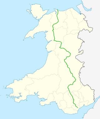
The A470 is a trunk road in Wales. It is the country's longest road at 186 miles (299 km) and links the capital Cardiff on the south coast to Llandudno on the north coast. While previously one had to navigate the narrow roads of Llanidloes and Dolgellau, both these market towns are now bypassed due to extensive road modernisation. The 26 miles (42 km) from Cardiff Bay to Merthyr Tydfil are mainly dual carriageway, but most of the route from north of Merthyr to Llandudno is single carriageway.

The A46 is a major A road in England. It starts east of Bath, Somerset and ends in Cleethorpes, Lincolnshire, but it does not form a continuous route. Large portions of the old road have been lost, bypassed, or replaced by motorway development. Between Leicester and Lincoln the road follows the course of the Roman Fosse Way, but between Bath and Leicester, two cities also linked by the Fosse Way, it follows a more westerly course.

The A48 is a trunk road in Great Britain running from the A40 at Highnam, 3 miles (4.8 km) west of Gloucester, England, to the A40 at Carmarthen, Wales. Before the Severn Bridge opened on 8 September 1966, it was a major route between England and South Wales. For most of its route, it runs almost parallel to the M4 motorway. During times of high winds at the Severn Bridge, the A48 is used as part of the diversion route and is still marked as a Holiday Route.

The A49 is an A road in western England, which traverses the Welsh Marches region. It runs north from Ross-on-Wye in Herefordshire via Hereford, Leominster, Ludlow, Shrewsbury and Whitchurch, then continues through central Cheshire to Warrington and Wigan before terminating at its junction with the A6 road just south of Bamber Bridge, near the junction of the M6, M65 and M61 motorways.

Pontyclun railway station is an unstaffed, minor railway station in Pontyclun, in the County Borough of Rhondda Cynon Taf, South Wales. The station is at street level, on Station Approach, Pontyclun. It is a stop on the South Wales Main Line, served by trains on the Maesteg Line, and occasionally by the Swanline Cardiff to Swansea regional services, as well as one early-morning daily service to Manchester and a late-night daily service to Carmarthen. The station and all trains are operated by Transport for Wales Rail.

Treforest railway station is a railway station serving the village of Treforest, Rhondda Cynon Taf, Wales. It is located on the Merthyr Line and the Rhondda Line 18 km north west of Cardiff Central. Passenger services are provided by Transport for Wales.

The Barry Railway Company was a railway and docks company in South Wales, first incorporated as the Barry Dock and Railway Company in 1884. It arose out of frustration among Rhondda coal owners at congestion and high charges at Cardiff Docks as well the monopoly held by the Taff Vale Railway in transporting coal from the Rhondda. In addition, the Taff Vale did not have the required capacity for the mineral traffic using the route, leading to lengthy delays in getting to Cardiff.

Talbot Green is a town just north of the M4 motorway, in the County Borough of Rhondda Cynon Taf, Wales in the United Kingdom. The town is part of Llantrisant Community Council.

The A556 is a road in England which extends from the village of Delamere in Cheshire West and Chester to the Bowdon Interchange in Cheshire East, bordering Greater Manchester. The road contains a mixture of single and dual carriageway sections and forms a large part of the route between Manchester and Chester. It also acts as a major access route to Chester/North Wales to the west and to Manchester to the east for the conurbation of towns and villages around the Dane Valley centering on Winsford and Northwich. The central part, which forms the Northwich Bypass between Davenham and Lostock Gralam, suffers because of the amount of commuter traffic from this area. The part of the route between the M6 motorway Junction 19 and the M56 motorway Junction 7 is a major route into Manchester and has been recently upgraded to a four-lane dual carriageway.

The A4119 links Tonypandy with Cardiff in South Wales.
Llantwit Fardre is a large village and community situated on the A473, Pontypridd to Bridgend, road near the Welsh towns of Pontypridd and Llantrisant. Llantwit Fardre is also the name of the old parish and the community area that takes in the villages of Llantwit Fardre, Tonteg and Church Village. It is in the county of Rhondda Cynon Taf.

Church Village is a large village in the historic parish and community of Llantwit Fardre, located within the Taff Ely district of the County Borough of Rhondda Cynon Taf in Wales. The village is centrally located being around 4 miles (6.4 km) from the local principal towns of Llantrisant to the southwest and Pontypridd to the north and is situated around 10 miles (16 km) northwest of Cardiff city centre.

The A4226 is a main road linking Bonvilston to Barry and Cardiff International Airport (CIA) in the Vale of Glamorgan, Wales.

Tonteg is a village around three and a half miles (6 km) from Pontypridd, south Wales. It is 9 miles (14.5 km) north west of Cardiff and four miles (6.5 km) north east of Llantrisant. The village is within the community of Llantwit Fardre. Tonteg is to the north west of the Garth Mountain, on the west side of the River Taff valley, at the top of a hill known locally as Powerstation Hill. The hill gets its name from the Upper Boat power station which was situated at the bottom of the hill until it was demolished in 1972. Tonteg is next to Church Village and the boundaries between the two villages are blurred. A significant part of the Treforest Industrial Estate falls within the Willowford area of Tonteg.

The Afon Clun is a 14-mile (23 km) long tributary of the River Ely, in the counties of Cardiff and Rhondda Cynon Taf, Wales. Its bedrock is predominantly of sandstone. Beginning on the western slope of The Garth the river is fast-flowing, in clear shallow water with a hard substrate, flowing to the south of Llantrisant and generally west to its confluence with the River Ely at Pontyclun, falling 715 feet (218 m) over its course.
The Llantrisant and Taff Vale Junction Railway was a railway company that constructed a standard gauge line in South Wales, connecting Llantrisant and the Taff Vale Railway near Treforest. It ran through thinly populated country, and linked to a number of iron mines, collieries and other mineral sites. It opened in stages in 1863 and 1864. In 1865 through passenger trains from the Cowbridge Railway ran over the line, to Pontypridd, although for some time there were no passenger stations on its own network. At the Llantrisant end, it was reliant on broad gauge railway companies which were not always friendly to it. The company leased its line to the Taff Vale Railway in 1870.

Tonteg Halt refers to two railway stations serving the township of Tonteg in Rhondda Cynon Taf, Wales. They were located on the Llantrisant and Taff Vale Junction Railway and latterly on the Barry Railway under the Great Western Railway.