History
Founded as a ford point across the River Taff, Upper Boat was mainly untouched by the booming coal and steel industry around which much of the industrialised south Wales grew. When the Glamorganshire Canal was constructed in the late 18th century, Upper Boat found itself located between the Taff and the canal, which brought employment to the area. [1] In the 1841 census, Upper Boat had a population of around 150, and its industry was clearly connected to the waterways that border it; employing boatmen, lock keepers, and carpenters. [1] Others found work at the collieries that opened in neighbouring villages, or at the local Melin-gorwg iron foundry. [1]
As no major coal mine was sunk in the locality of Upper Boat, its growth was gradual; and by 1901, its population had increased to little over 300. With the canal and the foundry now in decline, almost all employment in the village was reliant on coal mining, with people commuting to nearby pits. [1] In 1902, the construction of the Upper Boat power station was initiated by the South Wales Electric Company. Located on the west bank of the Taff, the coal-fired power station provided employment for several decades, until it was decommissioned in 1972, and then demolished in 1976, following events linked to the nationalisation of the electricity supply industry in Britain. [1] [2]
In 1936, the Treforest Industrial Estate was conceived; to bring employment to the area. By the end of the following year, three factories were built, employing 69 people. [1] As the estate grew, the fields surrounding the area were consumed by urban sprawl; housing was quickly required for local employees. Prefabricated houses were hastily built, and the village grew, but the decision to build the A470 trunk road in the early 1970s across the north of Upper Boat saw these homes removed via a compulsory demolition order. [1]
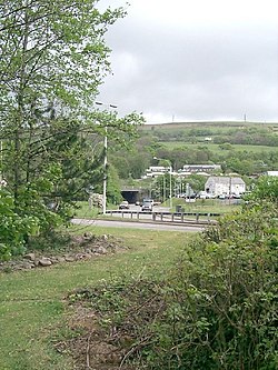
Upper Boat was once served by two separate railway stations on different lines. The first (which was called Upper Boat Halt after 1924), on the Pontypridd, Caerphilly and Newport Railway, was opened in 1904, and closed in 1956. The second (called 'Upper Boat' throughout its life), was on the Cardiff Railway, opening in 1911, and closing in 1931. The nearest station is now Treforest Estate. [3]

Pontypridd, colloquially referred to as Ponty, is a town and a community in Rhondda Cynon Taf, South Wales, approximately 10 miles north west of Cardiff city centre.

Rhondda Cynon Taf is a county borough in the south-east of Wales. It consists of five valleys: the Rhondda Fawr, Rhondda Fach, Cynon, Taff and Ely valleys, plus several towns and villages away from the valleys.

Treorchy is a town and community in Wales. Once a mining town, it retains such characteristics. Situated in the county borough of Rhondda Cynon Taf in the Rhondda Fawr valley. Treorchy is also one of the 16 communities of the Rhondda. It includes the villages of Cwmparc and Ynyswen.

Mountain Ash is a town and former community in the Cynon Valley, within the County Borough of Rhondda Cynon Taf, Wales, with a population of 11,230 at the 2011 Census, estimated in 2019 at 11,339. It includes the districts and villages of Cefnpennar, Cwmpennar, Caegarw, Darranlas, Fernhill, Glenboi and Newtown, all within the historic county boundaries of Glamorgan. Aberdare lies about 4.5 miles (7.2 km) north-west, Cardiff 19 miles (31 km) south-east, and Penrhiwceiber a mile to the south-east. It divides into two communities : West covers the town centre and the districts of Miskin, Darranlas, Fernhill and Glenboi, and East the districts of Cefnpennar, Cwmpennar, Caegarw and Newtown.

Ynysybwl is a village in Cwm Clydach in Wales. It is situated in the county borough of Rhondda Cynon Taf, roughly 15 miles (24 km) north-north-west of Cardiff, 4 miles (6 km) north of Pontypridd and 16 miles (26 km) south of Merthyr Tydfil, and forms part of the community of Ynysybwl and Coed-y-Cwm.

The River Taff is a river in Wales. It rises in the Brecon Beacons as two rivers, the Taf Fechan and the Taf Fawr before becoming one just north of Merthyr Tydfil. At Cardiff, it empties into the Bristol Channel.

Treforest is a village in the south-east of Pontypridd, in the county borough of Rhondda Cynon Taf, Wales. It is situated in the Treforest electoral ward, along with the village of Glyntaff. It is part of the Pontypridd Town community. Treforest runs along the west bank of the River Taff, while Glyntaff runs along its east bank.

Abercynon is a village and community in the Cynon Valley within the unitary authority of Rhondda Cynon Taf, Wales. The community comprises the village and the districts of Carnetown and Grovers Field to the south, Navigation Park to the east, and Glancynon to the north.

Rhydyfelin is a large village and part of the community of Pontypridd Town, about two miles to its south east of Pontypridd, in the county borough of Rhondda Cynon Taf. It is on the eastern bank of the River Taff close to the A470, and historically was in the parish of Eglwysilan.

Ynyshir is a village and community located in the Rhondda Valley, within Rhondda Cynon Taf, South Wales. The name of the village means "long island" in Welsh and takes its name from a farm in the area, falling within the historic parishes of Ystradyfodwg and Llanwynno (Llanwonno). The community of Ynyshir lies between the small adjoining village of Wattstown and the larger town of neighbouring Porth.
Taff's Well is a semi-rural village, community and electoral ward located at the south-eastern tip of Rhondda Cynon Taf, 6 miles (9.7 km) to the north of Cardiff, the capital city of Wales. Known locally as the 'Gates to the Valleys' by some and considered part of the Valleys by others, it is separated from Gwaelod-y-Garth by the River Taff. Taff's Well is distinguished because it contains the only thermal spring in Wales. The tepid water is thought to rise along a fault-line from the Carboniferous Limestone, in somewhat similar manner to the warm springs at Bristol and Bath. The Welsh myth of the Taff's Well Turtle originates here. Various religious groups regard it as a spiritual site.
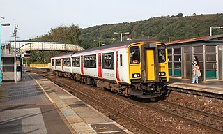
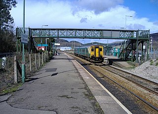
Treforest railway station is a railway station serving the village of Treforest, Rhondda Cynon Taf, Wales. It is located on the Merthyr Line and the Rhondda Line 18 km north west of Cardiff Central. Passenger services are provided by Transport for Wales.

Penrhiwceiber is a small Welsh village and community in the county borough of Rhondda Cynon Taf that lies south of the town Aberpennar and north of the village of Tyntetown, and is one of many villages that lies within the Cynon Valley. Prior to 1870 the area was heavy woodland, but the opening of the Penrhiwceiber Colliery in 1878 saw its rapid expansion into a thriving village.

Dinas is a village near Tonypandy in the county borough of Rhondda Cynon Taf, Wales. Dinas is often referred to as Dinas Rhondda to avoid confusion with Dinas Powys in the Vale of Glamorgan. The word dinas in Modern Welsh means "city", but here it means "hill fort".
Church Village is a large village in the historic parish and community of Llantwit Fardre, located within the Taff Ely district of the County Borough of Rhondda Cynon Taf in Wales. The village is centrally located being around 4 miles (6.4 km) from the local principal towns of Llantrisant to the southwest and Pontypridd to the north and is situated approximately 8 miles northwest of Cardiff city centre.

Tonteg is a village in Rhondda Cynon Taf in South Wales. It is 4 miles (6.4 km) from Pontypridd, 9 miles (14.5 km) north west of Cardiff and 4 miles (6.44 km) north east of Llantrisant. The village is within the community of Llantwit Fardre. Tonteg is to the north west of the Garth Mountain, on the west side of the River Taff valley, at the top of a hill known locally as Powerstation Hill. The hill gets its name from the Upper Boat power station which was situated at the bottom of the hill until it was demolished in 1972. Tonteg is next to Church Village and the boundaries between the two villages are blurred. A significant part of the Treforest Industrial Estate falls within the Willowford area of Tonteg.

Cilfynydd is a village in the county borough of Rhondda Cynon Taf, Wales, a mile from the South Wales Valleys town of Pontypridd, and 13 miles north of the capital city, Cardiff. Cilfynydd is also an electoral ward for the county council and Pontypridd Town Council.

Trallwn is a district, and as Trallwng, an electoral ward, within the town of Pontypridd, Rhondda Cynon Taf, South Wales, sited along the banks of the River Taff and falling within the historic parish of Eglwysilan. Trallwn comprises the subdistricts of Coedpenmaen (Coed-Pen-Maen), Ynysangharad and Pontypridd Common. Until recently Trallwn was also home to the famous Brown Lenox (Newbridge) Chain & Anchor Works at Ynysangharad, which was recently demolished. Also at Ynysangharad are some of the last remains of the Glamorganshire Canal which was used to transport coal and iron from the South Wales Valleys to the city of Cardiff. Ynysangharad is also home to Pontypridd's War Memorial Park - Ynysangharad Park.

Rhondda Cynon Taf is a county borough in South Wales. It is located to the north-west of Cardiff and covers an area of 424 km2 (164 sq mi). In 2021 the population was approximately 237,500.
Rhondda Cynon Taf is a county borough in South Wales. It is located to the north-west of Cardiff and covers an area of 424 km2 (164 sq mi). In 2021 the population was approximately 237,500.