Penrhiwceiber

Last updated

Penrhiwceiber
Stwinifredspenrhiwceiber.jpg
Eglwys Santes Gwenffrewi (English St Winifred's Church)
Rhondda Cynon Taf UK location map.svg
Red pog.svg
Penrhiwceiber
Location within Rhondda Cynon Taf
Population6,789 (2011) [1]
OS grid reference ST0597
Community
  • Penrhiw-ceiber [2]
Principal area
Ceremonial county
Country Wales
Sovereign state United Kingdom
Post town Mountain Ash/Aberpennar
Postcode district CF45
Dialling code 01443
Police South Wales
Fire South Wales
Ambulance Welsh
UK Parliament
Senedd Cymru – Welsh Parliament
List of places
UK
Wales
Rhondda Cynon Taf
51°40′12″N3°21′40″W / 51.670°N 3.361°W / 51.670; -3.361 Coordinates: 51°40′12″N3°21′40″W / 51.670°N 3.361°W / 51.670; -3.361

Penrhiwceiber is a small Welsh village and community (and electoral ward) in the county borough of Rhondda Cynon Taf that lies south of the town Aberpennar and north of the village of Tyntetown, and is one of many villages that lies within the Cynon Valley. Prior to 1870 the area was heavy woodland, but the opening of the Penrhiwceiber Colliery in 1878 saw its rapid expansion into a thriving village.

Contents

Etymology

Penrhiwceiber, according to Thomas Morgan in his 1887 publication, should be worded as Pen-Rhiw-Cae-Byr - 'Top of the hill of the little field'. [3] Other thoughts refer to the word ceiber, which means joist, beam or rafter and may suggest a place where timber was plentiful, which would certainly describe the area, which was a heavy woodland, before the coming of the coal trade. [4]

History

Penrhiwceiber was once a heavily wooded area with steep sloping mountainsides up until the last 20 years of the 19th century. According to the 1871 Census Records the village of Penrhiwceiber is not listed, however in 1881 the Census lists a number of streets within the village of Penrhiwceiber, notably Railway Terrace, Cynon Terrace, Glanlay Street and Penrhiwceiber Road. [4] This rapid growth was connected to the burgeoning coal trade and the construction of the Penrikyber Colliery in 1878. [5] The sinking of the colliery was first attempted in 1872 by a Mr. Thomas of Cwmbach on behalf of a group of businessmen who set themselves up as the Penrhiwceiber Navigation Collieries Company. [6] After facing problems such as running water and soft sand beds, the first commercial coal was raised from the mine in 1879, though the pit was serviced by a simple wooden headgear with a single rope. [6] Growth was rapid, and in an 1896 report by the Inspector of Mines, the colliery was employing 1,463 men. By 1908, that number was close to 1,800. [6] In 1909 the colliery suffered a pit fire which saw the lives of 30 men saved by the actions of the fire brigade. There was one fatality. [6] [7] [8]

The school primary school in the area is Penrhiwceibr Primary School (Welsh: Ysgol Gynradd Penrhiwceibr) which was originally built in 1881 and which provides further evidence as to the rapid growth of the village, with its having to be enlarged on three separate occasions: in 1893, 1895 and 1901.

This growth was to continue into the 20th century until in 1920 the Kelly's Trade Directory was able to list over one hundred commercial properties for Penrhiwceiber, as well as railway stations (Penrhiwceiber railway station) on both the Great Western and Taff Vale railways, religious buildings including Carmel Chapel (1880), Moriah Chapel, Bethel Eglwys-y-Wesleyaid (1884), Saint Winifred's Church (Welsh: Eglwys Santes Gwenffrewi) (1883), and the Penrhiwceiber Workmen's Hall and Institute (Welsh: Neuadd a Sefydliad y Gweithwyr Penrhiwceibr) built in 1888.

In Penrhiwceiber there is a clock tower memorial that was erected in memory of those who died while serving in World War I, World War II and the Korean War.

Penrhiwceiber Workmen's Hall and Institute (Welsh: Sefydliad a Neuadd y Gweithwyr Penrhiwceibr) was opened in the village in 1888 and restored in 1992. It remains one of the most prominent landmarks in the village. The former public library, on Rheola Street, closed in 2014. [9]

Coal mining

Penrhiwceiber was an important area for coal mining for the first half of the 20th century, it was home to two Coal Mines, which were:

Where Penrhiwceiber Colliery once sat, is now a local park and football and rugby fields which is locally known as Glasbrook Field. Where the Cwm Cynon Colliery once sat is now an industrial park and an industrial estate with few factories known as Parc Busnes Cwm Cynon (English: Cwm Cynon Business Park) and the Ystad Ddiwydiannol Cwm Cynon (English: Cwm Cynon Industrial Estate).

Religion

War Memorial and Clock Tower Penrhiwceiber Clock Tower War Memorial by Aberdare Blog.jpg
War Memorial and Clock Tower

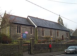
Penrhiwceiber falls within the historic Parish of Llanwynno, Church in Wales. The local St Winifred's Church (Welsh: Eglwys Santes Gwenffrewi) was built in 1883. [10]

The other church, All Saints (Tyntetown), was built in 1903 to serve the two communities of Tyntetown and Ynysboeth. Originally a daughter church of Penrhiwceiber, it became an independent parish fairly early on, before rejoining Penrhiwceiber in 1972. [11] There used to be a Salvation Army corps in the village. [12]

There were a number of nonconformist chapels at Penrhiwceiber including Jerusalem (Baptist), Carmel (Independent) and Hermon (Calvinistic Methodist).

Penrhiwceiber is home to Cylch Meithrin Penrhiwceiber which is a Welsh language pre-school for local children. Penrhiwceiber is generally known as "Ceiber" to the locals. To the east of the village lies Mynydd Twyn Brynbychan which is around 1,500 ft above sea level, the village is one of the steepest in Wales, and possibly the United Kingdom. The community and electoral ward of Penrhiwceiber includes both the village itself as well as the districts of Perthcelyn and Miskin.

Governance

Penrhiw-ceibr (formerly Penrhiwceiber) is the name of the electoral ward which is coterminous with the community. The ward elects two county councillors to Rhondda Cynon Taf County Borough Council. The ward has been represented since 1995 by both Labour Party and Plaid Cymru councillors, though both councillors were from Labour between 2004 and 2017. [13]

In a surprise result at the May 2017 council elections, veteran Labour councillor Jane Ward lost her seat to Gavin Williams, of the new Cynon Valley Party. [14]

Related Research Articles

<span class="mw-page-title-main">Maerdy</span> Human settlement in Wales

Maerdy is a village and community in the county borough of Rhondda Cynon Taf, and within the historic county boundaries of Glamorgan, Wales, lying at the head of the Rhondda Fach Valley.

<span class="mw-page-title-main">Treorchy</span> Human settlement in Wales

Treorchy is a town and community in Wales. Once a mining town, it retains such characteristics. Situated in the county borough of Rhondda Cynon Taf in the Rhondda Fawr valley. Treorchy is also one of the 16 communities of the Rhondda. It includes the villages of Cwmparc and Ynyswen.

<span class="mw-page-title-main">Mountain Ash, Rhondda Cynon Taf</span> Town in Cynon Valley, Wales

Mountain Ash is a town and former community in the Cynon Valley, within the County Borough of Rhondda Cynon Taf, Wales, with a population of 11,230 at the 2011 Census, estimated in 2019 at 11,339. It includes the districts and villages of Cefnpennar, Cwmpennar, Caegarw, Darranlas, Fernhill, Glenboi and Newtown, all within the historic county boundaries of Glamorgan. Aberdare lies about 4.5 miles (7.2 km) north-west, Cardiff 19 miles (31 km) south-east, and Penrhiwceiber a mile to the south-east. It divides into two communities : West covers the town centre and the districts of Miskin, Darranlas, Fernhill and Glenboi, and East the districts of Cefnpennar, Cwmpennar, Caegarw and Newtown.

<span class="mw-page-title-main">Ynysybwl</span> Human settlement in Wales

Ynysybwl is a village in Cwm Clydach in Wales. It is situated in the county borough of Rhondda Cynon Taf, roughly 15 miles (24 km) north-north-west of Cardiff, 4 miles (6 km) north of Pontypridd and 16 miles (26 km) south of Merthyr Tydfil, and forms part of the community of Ynysybwl and Coed-y-Cwm.

<span class="mw-page-title-main">Llwynypia</span> Human settlement in Wales

Llwynypia is a village and community in Rhondda Cynon Taf, Wales, near Tonypandy in the Rhondda Fawr Valley. Before 1850 a lightly populated rural farming area, Llwynypia experienced a population boom between 1860 and 1920 with the sinking of several coal mines after the discovery of large coal deposits throughout the Rhondda Valleys.

<span class="mw-page-title-main">Ynyshir</span> Human settlement in Wales

Ynyshir is a village and community located in the Rhondda Valley, within Rhondda Cynon Taf, South Wales. The name of the village means "long island" in Welsh and takes its name from a farm in the area, falling within the historic parishes of Ystradyfodwg and Llanwynno (Llanwonno). The community of Ynyshir lies between the small adjoining village of Wattstown and the larger town of neighbouring Porth.

<span class="mw-page-title-main">Ferndale, Rhondda Cynon Taf</span> Human settlement in Wales

Ferndale is a town and community located in the Rhondda Valley in the county borough of Rhondda Cynon Taf, Wales. Neighbouring villages are Blaenllechau, Maerdy and Tylorstown. Ferndale was industrialised in the mid-19th century. The first coal mine shaft was sunk in 1857 and was the first community to be intensively industrialised in the Rhondda Valley.

<span class="mw-page-title-main">Beddau</span> Human settlement in Wales

Beddau is a large former mining village situated within the South Wales Valleys around 1.5 miles (2.4 km) from Llantrisant and 4 miles (6.4 km) from the larger town of Pontypridd in the county borough of Rhondda Cynon Taf, South Wales.

<span class="mw-page-title-main">Cwmbach</span> Human settlement in Wales

Cwmbach is a village and community near Aberdare, in the county borough of Rhondda Cynon Taf, Wales. Cwmbach means 'Little Valley' in Welsh. Cwmbach has a population of 5,117.

<span class="mw-page-title-main">Ystrad</span> Human settlement in Wales

Ystrad is a village and community in the Rhondda Fawr valley, Rhondda Cynon Taf, Wales.

<span class="mw-page-title-main">Tylorstown</span> Human settlement in Wales

Tylorstown (Pendyrus) is a village and community located in the Rhondda valley, in the county borough of Rhondda Cynon Taf, Wales. It is neighboured by the villages of Blaenllechau, Ferndale, Penrhys, Pontygwaith and Stanleytown.

<span class="mw-page-title-main">Clydach Vale</span> Village in Rhondda Cynon Taf, Wales

Clydach Vale is a village in the community of Cwm Clydach, northwest of Tonypandy in the county borough of Rhondda Cynon Taf, within the Rhondda Valley, Wales. It is named for its situation on the Nant Clydach, a tributary of the River Rhondda. The village is deemed part of the Tonypandy built-up area by the Office for National Statistics and comes under the Tonypandy post town.

<span class="mw-page-title-main">Gilfach Goch</span> Human settlement in Wales

Gilfach Goch is a community, electoral ward and small former coal mining village mostly in the Borough of Rhondda Cynon Taf, south Wales, near the larger community of Tonyrefail. Some areas in the North Western part of the village lie within Bridgend County Borough. It is situated in the Cwm Ogwr Fach between the Cwm Ogwr Fawr to the west and the Cwm Rhondda to the east.

<span class="mw-page-title-main">Penygraig</span> Human settlement in Wales

Penygraig is a village and community in the Rhondda Valley in the county borough of Rhondda Cynon Taf, Wales. As a community Penygraig contains the neighbouring districts of Dinas, Edmondstown, Penrhiwfer and Williamstown. Penygraig is within the historic county boundaries of Glamorgan. The name Penygraig is Welsh for 'head of the rock'.

Pentre is a village, community and electoral ward near Treorchy in the Rhondda valley, falling within the county borough of Rhondda Cynon Taf, Wales. The village's name is taken from the Welsh word Pentref, which translates as homestead, though Pentre is named after a large farm that dominated the area before the coming of industrialisation. The community takes in the neighbouring village of Ton Pentre.

<span class="mw-page-title-main">Ynysboeth</span> Human settlement in Wales

Ynysboeth is a local community within the Mountain Ash (Aberpennar) postal district of the Cynon Valley in the County Borough of Rhondda Cynon Taf, South East Wales.

<span class="mw-page-title-main">Graig, Pontypridd</span> Human settlement in Wales

Graig is a historic district of the town of Pontypridd, Rhondda Cynon Taf, South Wales. It is also the name of an electoral ward for the town and county councils.

Cwm Clydach is a community and electoral ward to the northwest of Tonypandy in Rhondda Cynon Taf, Wales. The community and ward covers the valley of the Nant Clydach, which includes the cojoined villages of Clydach Vale and Blaenclydach.

Penrhiw-ceibr is the name of an electoral ward in the Cynon Valley, Rhondda Cynon Taf, Wales. It's boundaries are coterminous with the village and community of Penrhiwceiber. The ward elects two councillors to Rhondda Cynon Taf County Borough Council.

References

  1. "Community population 2011" . Retrieved 16 November 2015.
  2. "Penrhiw-ceiber Community". Mapit. Retrieved 23 May 2022.
  3. Morgan, Thomas (1887). The Place Names of Wales. Printed for the author by H.W. Southey. p.  195.
  4. 1 2 "Penrhiwceiber". webapps.rhondda-cynon-taff.gov.uk. Retrieved 30 April 2016.
  5. Davies, John; Jenkins, Nigel; Menna, Baines; Lynch, Peredur I., eds. (2008). The Welsh Academy Encyclopaedia of Wales. Cardiff: University of Wales Press. p. 665. ISBN   978-0-7083-1953-6.
  6. 1 2 3 4 "Penrhiwceiber Colliery" . Retrieved 30 April 2016.
  7. "Penrhiwceiber Pit Fire". Evening Express and Evening Mail. 4 November 1909. Retrieved 30 April 2016.
  8. "The Penrhiwceiber Pit Fire". The Merthyr Express. 13 November 1909. Retrieved 30 April 2016.
  9. Houghton, Tom (2 May 2017). "The old Penrhiwceiber Library is going up for auction". Wales Online.
  10. Newman, John (1995). Glamorgan. London: Penguin Group. p. 452. ISBN   0140710566.
  11. penrhiwceiber.org| welcome to our new website!
  12. "Sawiki.net page". Archived from the original on 8 January 2009. Retrieved 5 May 2009.
  13. Rhondda Cyon Taff County Borough Council Election Results 1995-2012, The Election Centre. Retrieved 2 April 2018.
  14. Thomas Deacon (5 May 2017). "Labour clings on to power as Plaid Cymru surge isn't enough to win power in Rhondda Cynon Taf". Wales Online. Retrieved 2 April 2018.

Location Grid