External links
Coordinates: 51°45′03″N3°34′22″W / 51.7508°N 3.5728°W
Cefn Rhigos (name meaning '(the) ridge (at) Rhigos') is a hamlet (place) to the west of the village of Rhigos, Wales. Despite being eight miles from the town centre, for postal purposes it comes under Aberdare.
It is the most westerly named settlement of the Cynon Valley. The border with The Vale of Neath lies a few hundred yards to the west.
Coordinates: 51°45′03″N3°34′22″W / 51.7508°N 3.5728°W

West Glamorgan is a former administrative county in South Wales. It is now a preserved county.

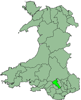
Cynon Valley is a former coal mining valley in Wales. Cynon Valley lies between Rhondda and the Merthyr Valley and takes its name from the River Cynon. Aberdare is located in the north of the valley and Mountain Ash is in the south of the valley.

The Taff Trail is a popular walking and cycle path that runs for 55 miles (89 km) between Cardiff Bay and Brecon in Wales. It is so named because it follows the course of the River Taff. Along much of its length, it follows the National Cycle Network Route 8 that continues to Holyhead, and is substantially off-road.

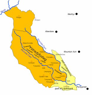
Ystradyfodwg or Ystrad Dyfodwg was an ancient upland parish in Glamorgan, Wales. It is believed to have been named after Dyfodwg a 6th-century saint or chieftain. The Parish included most of the area which would later be known as Rhondda named for the parish rivers, Rhondda Fawr and Rhondda Fach.

Cefn Bryn is an ancient ridge in Britain. It is a 5-mile-long Old Red Sandstone ridge in south Wales, in the heart of the Gower Peninsula, in the City and County of Swansea. Local people colloquially refer to it as the "backbone of Gower", as it protrudes from surrounding limestone. The highest point on the ridge is the second highest point in the peninsula, offering panoramic views of the surrounding country and seas. The swathes of grassland around the ridge are known as Cefn Bryn Common.

Neath was one of the four local government districts of West Glamorgan, Wales from 1974 to 1996. It was formed from the municipal borough of Neath, along with all of Neath Rural District apart from Rhigos parish, which went to Cynon Valley district.

Rhigos is a small village on the saddle of higher ground between the Vale of Neath and the Cynon Valley. It was part of the old Neath Rural district Council under Glamorgan until 1974. The village then came under the jurisdiction of The Cynon Valley Borough which subsequently became Rhondda Cynon Taf, South Wales in 1996. It lies just off the old Aberdare road that was the main link between Aberdare and Glynneath, before the A465 road was extended in the 1960s. The hamlets of Cefn Rhigos and Cwm-Hwnt lie to the west of the main village.
Cefn Mably is a district located approximately 6 miles north of Cardiff city centre and 5 miles south-east of Caerphilly.
Cwm-Hwnt is a tiny hamlet to the west of Rhigos and south of Cefn Rhigos in the Cynon Valley, one of the South Wales Valleys.
Pelenna is an electoral ward coterminous with a community in Neath Port Talbot county borough, south Wales. The ward consists of some or all of the following areas: Cefn-Saeson, Tonmawr, Pontrhydyfen in the parliamentary constituency of Neath.
Cefn Glas is an area on the northwestern outskirts of the town of Bridgend, Wales. It is part of the community of Laleston.

The A4061 is the main road linking Bridgend with Hirwaun via the Ogmore and Rhondda Valleys in South Wales. It is a mix of streets connecting former mining communities, and mountain passes built as relief work for unemployed miners.

The A4054 is an A Road connecting Llandaff, Cardiff with Cefn-Coed-y-Cymmer in Wales and mostly follows the former route of the A470.

Cefn Hengoed is a small village in the centre of Caerphilly borough, within the historic boundaries of Glamorganshire. Bordering the larger village of Hengoed, Cefn Hengoed contains the local Derwendeg primary school. Derwendeg primary school has recently celebrated its 90th birthday. Cefn Hengoed is a Village in Caerphilly County Borough and within the Gelligaer Community Council Parish area.

Wexham School is a co-educational community school in Wexham Court, Slough, Berkshire.
Glynneath is the name of an electoral ward in Neath Port Talbot county borough, Wales.
Cadair Fawr is a hill in the northern corner of the county borough of Rhondda Cynon Taf, Wales. It lies within the Brecon Beacons National Park and Fforest Fawr Geopark. The 485m high summit at OS grid ref SN 978123 is marked by a trig point. Cadair Fawr is the highest point of a broad ridge known as Cefn Cadlan which forms the northern edge of Cwm Cadlan, a valley which itself runs east-northeastwards from the village of Penderyn. The name Cadair Fawr signifies the 'big chair' whilst Cefn Cadlan signifies the 'ridge of the battlefield'.

Cefn-coed-y-cymmer is a small community on the northwestern edge of Merthyr Tydfil County Borough in Wales. It is situated in the neck of land between the rivers Taf Fawr and Taf Fechan at their confluence. The village lies within the community of Vaynor. Immediately to the north of the village is the hill of Cefn Cil Sanws on the southern slopes of which is Merthyr Tydfil Golf Club. The village is bounded both to the north and the west by the Brecon Beacons National Park.

Llanfrynach is a village and community in the county of Powys, Wales, and the historic county of Brecknockshire. The population of the community as taken at the 2011 census was 571. It lies just to the southeast of Brecon in the Brecon Beacons National Park. The village sits astride the Nant Menasgin, a right bank tributary of the River Usk. The B4558 passes just to its north and the Monmouthshire and Brecon Canal also passes around the village. The Welsh name signifies the 'church of Brynach'. The community includes the hamlets of Llanhamlach and Groesffordd.