Llanharry

Last updated

Llanharry
The Bear Inn, Llanharry. - geograph.org.uk - 914766.jpg
Rhondda Cynon Taf UK location map.svg
Red pog.svg
Llanharry
Location within Rhondda Cynon Taf
Population3,643 (2011) [1]
OS grid reference ST005805
Principal area
Ceremonial county
Country Wales
Sovereign state United Kingdom
Post town Pontyclun
Postcode district CF72
Dialling code 01443
Police South Wales
Fire South Wales
Ambulance Welsh
UK Parliament
Senedd Cymru – Welsh Parliament
List of places
UK
Wales
Rhondda Cynon Taf
51°30′47″N3°25′48″W / 51.513°N 3.430°W / 51.513; -3.430 Coordinates: 51°30′47″N3°25′48″W / 51.513°N 3.430°W / 51.513; -3.430

Llanharry (Welsh : Llanhari) is a village, community (civil parish) and electoral ward in the county borough of Rhondda Cynon Taf, Wales.

Contents

Historically part of Glamorgan, Llanharry has been inextricably linked with iron mining as far back as the Roman period, and for a period in the 20th century it boasted the only iron mine in Wales.

The town is infamous for being the site of the murders of Harry and Megan Tooze, which remain some of Wales' most notorious unsolved murders. [2] [3]

Employment

St. Illtyd's Parish Church. Llanharry St. Illtyd's Parish Church. Llanharry - geograph.org.uk - 914773.jpg
St. Illtyd's Parish Church. Llanharry

Llanharry iron mine worked from the early 1900s but closed in 1976; [4] its main ore was goethite, which was used at the local ironworks. [5]

Since the closure of its mines and ironworks, Llanharry has been in economic decline, as are most South Wales Valleys villages once dependent on heavy industry. Llanharry's proximity to the M4 motorway in Wales has allowed its residents opportunities to commute to work more easily rather than seeking work locally.

Llanharry contains a few small local amenities, such as a corner shop and a hairdressers.

Education

Llanharry is home to Llanharry Primary School, built 1935 and Ysgol Gyfun Llanhari Welsh medium secondary school which was built in 1974. In 2012 the secondary school became Rhondda Cynon Taf's first 3-19 school, opening a new Welsh language primary department in the former sixth form block. [6]

Transportation

Buses are the main transportation links servicing Llanharry. Between 1871 and 1951, the village was served by Llanharry railway station, but there is no longer any local rail connection. [7] The nearest station is now Pontyclun. The M4 motorway skirts the southern end of the village, but there is no direct local access to it.

Social life

At the centre of Llanharry is Saint Illtud's Church which was built in 1867.
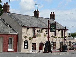
There is presently only one public houses in Llanharry; the Fox & Hounds, The Bear Inn is no longer open. Llanharry also has its own working men's club.

Llanharry is home to Llanharry AFC, a football team who compete in the Bridgend & District Premier Division. The team play in yellow shirts with black shorts & socks, and play their home games at The Recreation Ground in Llanharry.

Regeneration schemes

Llanharry benefits from the Llanharry Action for Change Project which uses funds, including money from the European Union, to support projects and improvements in the village.

Local politics

In terms of local politics Llanharry Community Council is responsible for representing the views of local people. To fund its activities, the Council receives a proportion of the council tax collected each year from every home in the village, depending on rateable value.

The Llanharry electoral ward is coterminous with the borders of the community [8] and elects a county councillor to Rhondda Cynon Taf County Borough Council. Since 1995 the ward has been represented by either the Labour Party or Plaid Cymru, [9] In the 2012 elections Labour Councillor Barry Stephens JP won the seat from Plaid Cymru and was elected Borough Councillor for Llanharry and Tylagarw. During his time in office he made many improvements to the previously neglected area including refurbishing and improving the main shopping area by adding paved areas with gardens and benches. He also put in a much needed path to The cemetery as previously residents had to walk in the road to get there. He was subsequently elected Mayor of Rhondda Cynon Taff 2015/2016. In the 2017 election Wayne Owen of the Boars Head Tylagarw won the seat as an Independent candidate. County Borough Council Elections 2017, Rhondda Cynon Taf County Borough Council. Retrieved 27 October 2018.

Related Research Articles

Maerdy Human settlement in Wales

Maerdy is a village and community in the county borough of Rhondda Cynon Taf, and within the historic county boundaries of Glamorgan, Wales, lying at the head of the Rhondda Fach Valley.

Treorchy Human settlement in Wales

Treorchy is a town and community in Wales. Once a mining town, it retains the characteristics of one. Situated in the county borough of Rhondda Cynon Taf in the Rhondda Fawr valley. Treorchy is also one of the 16 communities of the Rhondda. It includes the villages of Cwmparc and Ynyswen.

Tonypandy Human settlement in Wales

Tonypandy is a town, community and electoral ward located in the county borough of Rhondda Cynon Taf, within the historic county boundaries of Glamorgan, Wales, lying in the Rhondda Fawr Valley. A former industrial coal mining town, today Tonypandy is best known as the site of the 1910 Tonypandy riots.

Llwynypia Human settlement in Wales

Llwynypia is a village and community in Rhondda Cynon Taf, Wales, near Tonypandy in the Rhondda Fawr Valley. Before 1850 a lightly populated rural farming area, Llwynypia experienced a population boom between 1860 and 1920 with the sinking of several coal mines after the discovery of large coal deposits throughout the Rhondda Valleys.

Ynyshir Human settlement in Wales

Ynyshir is a village and community located in the Rhondda Valley, within Rhondda Cynon Taf, South Wales. Ynyshir is pronounced (ənɪs-hiːr) according to the International Phonetic Alphabet (IPA), and means "long island" in Welsh. The village takes its name from a farm in the area, falling within the historic parishes of Ystradyfodwg and Llanwynno (Llanwonno). The community of Ynyshir lies between the small adjoining village of Wattstown and the larger town of neighbouring Porth.

Ferndale, Rhondda Cynon Taf Human settlement in Wales

Ferndale is a town and community located in the Rhondda Valley in the county borough of Rhondda Cynon Taf, Wales. Neighbouring villages are Blaenllechau, Maerdy and Tylorstown. Ferndale was industrialised in the mid-19th century. The first coal mine shaft was sunk in 1857 and was the first community to be intensively industrialised in the Rhondda Valley.

Beddau Human settlement in Wales

Beddau is a large former mining village situated within the South Wales Valleys around 1.5 miles (2.4 km) from Llantrisant and 4 miles (6.4 km) from the larger town of Pontypridd in the county borough of Rhondda Cynon Taf, South Wales.

Penrhiwceiber Human settlement in Wales

Penrhiwceiber is a small Welsh village and community in the county borough of Rhondda Cynon Taf that lies south of the town Aberpennar and north of the village of Tyntetown, and is one of many villages that lies within the Cynon Valley. Prior to 1870 the area was heavy woodland, but the opening of the Penrhiwceiber Colliery in 1878 saw its rapid expansion into a thriving village.

Ystrad Human settlement in Wales

Ystrad is a village and community in the Rhondda Fawr valley, Rhondda Cynon Taf, Wales.

Tylorstown Human settlement in Wales

Tylorstown (Pendyrus) is a village and community located in the Rhondda valley, in the county borough of Rhondda Cynon Taf, Wales. It is neighboured by the villages of Blaenllechau, Ferndale, Penrhys, Pontygwaith and Stanleytown.

Pauline Jarman, is a Welsh politician. She was the Plaid Cymru National Assembly for Wales Member for South Wales Central from 1999 to 2003 as well as being leader of Rhondda Cynon Taff Council from 1999 - 2004.

Gilfach Goch Human settlement in Wales

Gilfach Goch is a community, electoral ward and small former coal mining village mostly in the Borough of Rhondda Cynon Taf, south Wales, near the larger community of Tonyrefail. Some areas in the North Western part of the village lie within Bridgend County Borough Council. It is situated in the Cwm Ogwr Fach between the Cwm Ogwr Fawr to the west and the Cwm Rhondda to the east.

Penygraig Human settlement in Wales

Penygraig is a village and community in the Rhondda Valley in the county borough of Rhondda Cynon Taf, Wales. As a community Penygraig contains the neighbouring districts of Dinas, Edmondstown, Penrhiwfer and Williamstown. Penygraig is within the historic county boundaries of Glamorgan. The name Penygraig is Welsh for 'head of the rock'.

Pentre is a village, community and electoral ward near Treorchy in the Rhondda valley, falling within the county borough of Rhondda Cynon Taf, Wales. The village's name is taken from the Welsh word Pentref, which translates as homestead, though Pentre is named after a large farm that dominated the area before the coming of industrialisation. The community takes in the neighbouring village of Ton Pentre.

Mountain Ash East Human settlement in Wales

Mountain Ash East is a community and coterminous electoral ward in Rhondda Cynon Taf, Wales. It primarily includes the part of the town of Mountain Ash east of the River Cynon. The community was formed in 2016 when the larger community of Mountain Ash was divided into East and West to match the ward boundaries.

The 2017 Rhondda Cynon Taf Council election took place on Thursday 4 May 2017 to elect members of Rhondda Cynon Taf County Borough Council in Wales. This was the same day as other 2017 United Kingdom local elections. The previous full council election took place on 3 May 2012 and the next full election took place in 2022.

Cwm Clydach is a community and electoral ward to the northwest of Tonypandy in Rhondda Cynon Taf, Wales. The community and ward covers the valley of the Nant Clydach, which includes the cojoined villages of Clydach Vale and Blaenclydach.

Mountain Ash is an electoral ward in Rhondda Cynon Taf, electing two councillors to Rhondda Cynon Taf County Borough Council. It was re-created by the merger of Mountain Ash East and Mountain Ash West, following a local government boundary review, effective from 5 May 2022, the date of the 2022 Welsh local elections.

Penrhiw-ceibr is the name of an electoral ward in the Cynon Valley, Rhondda Cynon Taf, Wales. It's boundaries are coterminous with the village and community of Penrhiwceiber. The ward elects two councillors to Rhondda Cynon Taf County Borough Council.

Mountain Ash East was the name of an electoral ward in the Cynon Valley, Rhondda Cynon Taf, Wales. It elected councillors to Cynon Valley Borough Council and later Rhondda Cynon Taf County Borough Council. It merged with Mountain Ash West to form the Mountain Ash ward in 2022.

References

  1. "Community population 2015" . Retrieved 16 November 2015.
  2. "The five other unexplained deaths linked to Pembrokeshire Murders killer John Cooper that have never been proved". WalesOnline. 16 January 2021. Retrieved 20 August 2022.
  3. Crime+ Investigation (20 April 2021). "The Llanharry Murders: South Wales - Murdertown Podcast Series 1 Episode 5". YouTube. Retrieved 20 August 2022.
  4. The Welsh Academy Encyclopaedia of Wales. John Davies, Nigel Jenkins, Menna Baines and Peredur Lynch (2008) pg500 ISBN   978-0-7083-1953-6
  5. Glamorgan Archives: Glamorgan Haematite Iron Ore Mine, Llanharry records Archived 2016-03-04 at the Wayback Machine . Accessed 5 June 2014
  6. http://www.rctcbc.gov.uk/services/en/legaldemocraticservices/councillorscommittees/meetings/cabinet/2011/09/26/reports/agendaitem4welshmediumeducationthefutureofygllanhari.pdf%5B%5D
  7. Chapman, C. (1984) The Cowbridge Railway. Oxford Publishing Company.
  8. "Election maps". Ordnance Survey . Retrieved 27 October 2018.
  9. Rhondda Cyon Taff County Borough Council Election Results 1995-2012, The Election Centre. Retrieved 27 October 2018.