Blaenrhondda

Last updated

Blaenrhondda
BlaenRhondda Rhondda.jpg
Rhondda Cynon Taf UK location map.svg
Red pog.svg
Blaenrhondda
Location within Rhondda Cynon Taf
OS grid reference SS928995
Principal area
Ceremonial county
Country Wales
Sovereign state United Kingdom
Post town TREORCHY
Postcode district CF42
Dialling code 01443
Police South Wales
Fire South Wales
Ambulance Welsh
UK Parliament
Senedd Cymru – Welsh Parliament
List of places
UK
Wales
Rhondda Cynon Taf
51°41′05″N3°33′05″W / 51.6847°N 3.5514°W / 51.6847; -3.5514 Coordinates: 51°41′05″N3°33′05″W / 51.6847°N 3.5514°W / 51.6847; -3.5514

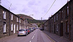
Blaenrhondda is a village in the county borough of Rhondda Cynon Taf, Wales, lying at the head the Rhondda Fawr valley. Blaenrhondda is a village and is part of the community of Treherbert.

Contents

History

The earliest evidence of people inhabiting the area are the remains of an Iron Age settlement of several roundhouses grouped together in an obvious community, known as Hen Dre'r Mynydd. The dry wall layout of the ruinous site has led archaeologists to believe that the people who lived in the area were early farmers. [1] It has been identified as the largest undefended Iron Age settlement in south east Wales.

Before the industrialisation of the Rhondda Valleys in the late 19th century, Blaenrhondda was an agricultural area and sparsely populated. With the coming of the coal industry two mines were sunk in the locality. The first was the North Dunraven, also known as the Blaenrhondda, sunk in 1859, followed by Fernhill Colliery around 1871. The Dunraven closed in the 1920s but the Fernhill was still operating as late as 1978. In an attempt to break the monopoly of the Taff Vale Railway and the Cardiff docks, the Rhondda Tunnel was constructed through Mynydd Blaengwynfy to link up with the Rhondda and Swansea Bay Railway to supply coal to the Swansea Docks for export. The resulting tunnel, at a length of 3,300 yards was the longest rail tunnel in Wales and the seventh longest in Britain. [2] Due to an issue with the weight the engines could pull, the rail link was never the success it was hoped to be, though it did prove popular with day-trippers from the Rhondda, visiting Swansea and the Gower. The station was closed in 1970.

In the hills above Blaenrhondda lies Blaenrhondda Road Cutting, a Site of Special Scientific Interest. It was given this status for its rock exposures showing sediments that formed on the flood plain of a river delta during the Carboniferous period, approximately 310 million years ago. [3]

Related Research Articles

<span class="mw-page-title-main">Treorchy</span> Human settlement in Wales

Treorchy is a town and community in Wales. Once a mining town, it retains such characteristics. Situated in the county borough of Rhondda Cynon Taf in the Rhondda Fawr valley. Treorchy is also one of the 16 communities of the Rhondda. It includes the villages of Cwmparc and Ynyswen.

<span class="mw-page-title-main">Tonypandy</span> Human settlement in Wales

Tonypandy is a town, community and electoral ward located in the county borough of Rhondda Cynon Taf, within the historic county boundaries of Glamorgan, Wales, lying in the Rhondda Fawr Valley. A former industrial coal mining town, the town was the scene of the 1910 Tonypandy riots.

<span class="mw-page-title-main">Mountain Ash, Rhondda Cynon Taf</span> Town in Cynon Valley, Wales

Mountain Ash is a town and former community in the Cynon Valley, within the County Borough of Rhondda Cynon Taf, Wales, with a population of 11,230 at the 2011 Census, estimated in 2019 at 11,339. It includes the districts and villages of Cefnpennar, Cwmpennar, Caegarw, Darranlas, Fernhill, Glenboi and Newtown, all within the historic county boundaries of Glamorgan. Aberdare lies about 4.5 miles (7.2 km) north-west, Cardiff 19 miles (31 km) south-east, and Penrhiwceiber a mile to the south-east. It divides into two communities : West covers the town centre and the districts of Miskin, Darranlas, Fernhill and Glenboi, and East the districts of Cefnpennar, Cwmpennar, Caegarw and Newtown.

<span class="mw-page-title-main">Llwynypia</span> Human settlement in Wales

Llwynypia is a village and community in Rhondda Cynon Taf, Wales, near Tonypandy in the Rhondda Fawr Valley. Before 1850 a lightly populated rural farming area, Llwynypia experienced a population boom between 1860 and 1920 with the sinking of several coal mines after the discovery of large coal deposits throughout the Rhondda Valleys.

<span class="mw-page-title-main">Abercynon</span> Human settlement in Wales

Abercynon, is both a village and a community in the Cynon Valley within the unitary authority of Rhondda Cynon Taf, Wales. The community comprises the village and the districts of Carnetown and Grovers Field to the south, Navigation Park to the east, and Glancynon to the north.

<span class="mw-page-title-main">Ynyshir</span> Human settlement in Wales

Ynyshir is a village and community located in the Rhondda Valley, within Rhondda Cynon Taf, South Wales. The name of the village means "long island" in Welsh and takes its name from a farm in the area, falling within the historic parishes of Ystradyfodwg and Llanwynno (Llanwonno). The community of Ynyshir lies between the small adjoining village of Wattstown and the larger town of neighbouring Porth.

<span class="mw-page-title-main">Rhondda</span> Urban area and district in South Wales

Rhondda, or the Rhondda Valley, is a former coalmining area in South Wales, historically in the county of Glamorgan. It takes its name from the River Rhondda, and embraces two valleys – the larger Rhondda Fawr valley and the smaller Rhondda Fach valley – so that the singular "Rhondda Valley" and the plural are both commonly used. The area forms part of the South Wales Valleys. From 1897 until 1996 there was a local government district of Rhondda. The former district at its abolition comprised sixteen communities. Since 1996 these sixteen communities of the Rhondda have been part of Rhondda Cynon Taf County Borough. The area of the former district is still used as the Rhondda Senedd constituency and Westminster constituency, having an estimated population in 2020 of 69,506. It is most noted for its historical coalmining industry, which peaked between 1840 and 1925. The valleys produced a strong Nonconformist movement manifest in the Baptist chapels that moulded Rhondda values in the 19th and early 20th centuries. It is also known for its male voice choirs and in sport and politics.

<span class="mw-page-title-main">South Wales Coalfield</span> Region of Wales rich in coal deposits

The South Wales Coalfield extends across Pembrokeshire, Carmarthenshire, Swansea, Neath Port Talbot, Bridgend, Rhondda Cynon Taf, Merthyr Tydfil, Caerphilly, Blaenau Gwent and Torfaen. It is rich in coal deposits, especially in the South Wales Valleys.

<span class="mw-page-title-main">Treherbert</span> Human settlement in Wales

Treherbert is a village and community situated at the head of the Rhondda Fawr valley in the county borough of Rhondda Cynon Taf, Wales. Historically part of Glamorgan, Treherbert is a former industrial coal mining village which was at its economic peak between 1850 and 1920. Treherbert is the upper most community of the Rhondda Fawr and encompasses the districts of Blaencwm, Blaenrhondda, Tynewydd and Pen-yr-englyn.

<span class="mw-page-title-main">Treherbert railway station</span> Railway station in Rhondda Cynon Taf, Wales

Treherbert railway station serves the village of Treherbert in Rhondda Cynon Taf, Wales. It is the northern terminus of the Rhondda Line, 23 miles (37 km) north west of Cardiff Central.

<span class="mw-page-title-main">Ton Pentre</span> Human settlement in Wales

Ton Pentre is a village in the Rhondda Valley in the county borough of Rhondda Cynon Taf, Wales. Historically part of Glamorgan, Ton Pentre, a former industrial coal mining village, is a district of the community of Pentre. The old district of Ystradyfodwg was named after the church at Ton Pentre. Ton Pentre is, perhaps, best known for an event in 1924, when the Duke of York played a round of golf with Trade Unionist Frank Hodges.

The Rhondda and Swansea Bay Railway was a Welsh railway company formed to connect the upper end of the Rhondda Fawr with Swansea, with the chief objective of transporting coal and other minerals to Swansea docks. It was incorporated in 1882, but at first the connection to Swansea from Briton Ferry was refused.

<span class="mw-page-title-main">Blaencwm</span> Human settlement in Wales

Blaencwm is a village in the county borough of Rhondda Cynon Taf, Wales, lying at the head the Rhondda Fawr valley. Two collieries were opened here during the Industrial Revolution, the Dunraven Colliery in 1865 and the Glenrhondda Colliery in 1911. Both had closed by 1966 and the sites have since been landscaped, leaving little trace of their industrial past. It is in the historic county of Glamorgan.

<span class="mw-page-title-main">Hopkinstown</span> Human settlement in Wales

Hopkinstown is a small village to the west of Pontypridd in the county borough of Rhondda Cynon Taf, Wales, alongside the River Rhondda. Hopkinstown is a former coalmining and industrial community, now a district in the town of Pontypridd within the Rhondda electoral ward. Neighbouring settlements are Pwllgwaun, Trehafod and Pantygraigwen, and the sub-districts of Troed-Rhiw-Trwyn and Gyfeillion.

<span class="mw-page-title-main">Afon Clun</span> River in Wales

The Afon Clun is a 14-mile (23 km) long tributary of the River Ely, in the counties of Cardiff and Rhondda Cynon Taf, Wales. Its bedrock is predominantly of sandstone. Beginning on the western slope of The Garth the river is fast-flowing, in clear shallow water with a hard substrate, flowing to the south of Llantrisant and generally west to its confluence with the River Ely at Pontyclun, falling 715 feet (218 m) over its course.

Tynewydd is a village located in the County Borough of Rhondda Cynon Taf, south Wales. With Treherbert, Blaencwm, Blaenrhondda and Pen-yr-englyn it is part of a community of Treherbert. The village lies in the former industrial coal mining area at the head of Rhondda Fawr, the larger of the Rhondda Valleys.

<span class="mw-page-title-main">Grade I listed buildings in Rhondda Cynon Taf</span> List of buildings in county borough of Wales

Rhondda Cynon Taf is a county borough in South Wales. It is located to the north-west of Cardiff and covers an area of 424 km2 (164 sq mi). In 2020 the population was approximately 241,900.

The Rhondda Tunnel is an abandoned railway tunnel that runs between the Rhondda and the Afan Valleys in South Wales. It is 3,443 yards (3,148 m) long, making it the third longest railway tunnel in Wales, and the seventeenth longest in the United Kingdom.

References

  1. BBC website - Celtic Heritage
  2. "Glamorgan Walks". Archived from the original on 23 July 2008. Retrieved 9 August 2008.
  3. "Blaenrhondda Road Cutting". ccw.gov.uk. Archived from the original on 5 June 2011. Retrieved 29 October 2011.