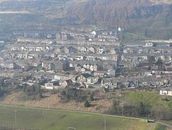
Ferndale, Rhondda Cynon Taf

Last updated

Ferndale
Ferndale, Rhondda Valley - geograph.org.uk - 52041.jpg
Rhondda Cynon Taf UK location map.svg
Red pog.svg
Ferndale
Location within Rhondda Cynon Taf
Population4,178 (2011) [1]
OS grid reference ST000964
Principal area
Preserved county
Country Wales
Sovereign state United Kingdom
Post town Ferndale
Postcode district CF43
Dialling code 01443
Police South Wales
Fire South Wales
Ambulance Welsh
UK Parliament
Senedd Cymru – Welsh Parliament
List of places
UK
Wales
Rhondda Cynon Taf
51°39′40″N3°26′53″W / 51.661°N 3.448°W / 51.661; -3.448

Ferndale (Welsh : Glynrhedynog) is a town and community located in the Rhondda Valley in the county borough of Rhondda Cynon Taf, Wales. Neighbouring villages are Blaenllechau, Maerdy and Tylorstown. Ferndale was industrialised in the mid-19th century. The first coal mine shaft was sunk in 1857 and Ferndale was the first community to be intensively industrialised in the Rhondda Valley. [2]

Contents

History

In Welsh, Ferndale is known as Glynrhedynog, the name of one of the old farms on which the town is built. In its infancy Glynrhedynog was also known as Trerhondda, after the name of the first large chapel to be built in the town. The naming of settlements after chapels was widespread in Wales at the time, but neither Glynrhedynog nor Trerhondda was used for long. Glynrhedynog is made from the words glyn (valley) and rhedynog (ferny), so coal from the Glynrhedynog pits was marketed as Ferndale coal, a much easier name for English buyers to assimilate.

The Ferndale pits drew workers and their families to the area, and by the 1880s Ferndale was well established as a thriving town. With the phasing in of bilingual road signs from the late 1980s onwards, the name Glynrhedynog gradually reappeared and is now the officially designated Welsh language name for Ferndale. The village adopted the English language during the Industrial Revolution, but the Welsh language is now on the increase in Ferndale. A Welsh language school is situated near the park and is named after the park's lake, Llyn-y-Forwyn (the Maiden's Lake).

Industry

The pioneer of coal mining at Ferndale was David Davis of Blaengwawr, Aberdare who already had an extensive colliery business in the neighbouring Aberdare Valley. His wealth enabled him to engage in costly but unsuccessful singings in the Rhondda Fach in the 1860s until he finally struck a good seam at Ferndale.

Ferndale Colliery disasters

Two large coal mining disasters occurred in Ferndale during the 19th century. The first took place on 8 November 1867, when an underground explosion killed 178 miners at the Ferndale Colliery owned by David Davis and Sons Ltd. The second disaster happened on 10 June 1869 when a further explosion resulted in the death of 53 miners. [3]

Governance

A Ferndale electoral ward was coterminous with the borders of the Ferndale community and elected two county councillors to Rhondda Cynon Taf County Borough Council. Since 1995, representation was mainly by the Labour Party, but the ward also had a Plaid Cymru councillor from 1999 to 2004 and an Independent councillor from 2012 to 2017. [4] At the May 2017 election, Labour and Plaid Cymru won a councillor each. [5]

Following a 2018 review of electoral arrangements by the Local Democracy and Boundary Commission for Wales, it was proposed to merge Ferndale with neighbouring Maerdy into the Ferndale and Maerdy ward. [6] The proposals took effect from the 2022 council elections, which saw Susan Morgans and Jayne Smith elected for Labour. [7]

Modern Ferndale

Ferndale has developed over recent years. Some new features have been added such as an 3G football field, car park and an all-weather cricket training enclosure. The Sky TV comedy series Stella is largely filmed on location in Ferndale. [8]

Transport

Between 1849 and 1856, the Taff Vale Railway opened the Maerdy Branch from Porth, including a station at Ferndale. Passenger services were withdrawn in 1964, but coal trains continued until August 1986 when the line closed completely. Coal from Mardy Colliery was then raised through Tower Colliery. The track was lifted in 1996. Since 2005, the southern section of the line from Porth to Pontygwaith has been used for the A4223 Porth and Lower Rhondda Fach Relief Road (Porth Bypass). [9] The upper section, including the section passing Ferndale, has become a branch of the Taff Trail cycleway.

Religion

The Old Morlais Chapel The Old Morlais Chapel, Ferndale - geograph.org.uk - 6142379.jpg
The Old Morlais Chapel

There are several chapels and churches in or near Ferndale:

Sport

View over the town Ferndale, view over the town.jpg
View over the town

Ferndale is home to rugby union club Ferndale RFC, whose first XV team play in the Welsh Rugby Union leagues.

Adjacent to Llyn y Forwyn is an AstroTurf football field that, during the summer, annually becomes the ground of sports days for many of the local junior schools. Darran Park has a tennis court and a bowling green.

Ferndale Bowls Club have a strong standing in the Welsh bowls community, with several players from the club representing Wales at International level in the past. J.S. Hill represented Wales in the 1930's with several others, including Gareth Hughes, Lee Morgans & Martin Jones, having represented Wales numerous times in more recent years at both Junior [15] and Senior [16] team level. The club were runners up in the Curruthers Shield in both 1947 and 2010. [17] The club is always well represented in the Welsh National Championships each year, with several players having won Welsh titles.

In December 2006, the Ferndale Skate Park was opened with indoor ramps and other equipment available to BMX riders, rollerbladers and skateboarders. The skate park began with the aim of improving the prospects of school leavers in the area, providing a 'safe haven' from the influences of drugs and alcohol, and encouraging sports and healthy living. It has since received National Lottery continuation funding as well as a Rhondda Trust grant to secure the future for an additional 3-year period[ citation needed ]. It closed in 2014. [18]

Notable people

Related Research Articles

<span class="mw-page-title-main">Pontypridd</span> Town in Wales

Pontypridd is a town and a community in Rhondda Cynon Taf, Wales.

<span class="mw-page-title-main">Rhondda Cynon Taf</span> County borough in Wales

Rhondda Cynon Taf is a county borough in the south-east of Wales. It consists of five valleys: the Rhondda Fawr, Rhondda Fach, Cynon, Taff and Ely valleys, plus a number of towns and villages away from the valleys.

<span class="mw-page-title-main">Maerdy</span> Human settlement in Wales

Maerdy is a village and community in the county borough of Rhondda Cynon Taf, and within the historic county boundaries of Glamorgan, Wales, lying at the head of the Rhondda Fach Valley.

<span class="mw-page-title-main">Treorchy</span> Human settlement in Wales

Treorchy is a town and community in Wales. Once a mining town, it retains such characteristics. Situated in the county borough of Rhondda Cynon Taf in the Rhondda Fawr valley. Treorchy is also one of the 16 communities of the Rhondda. It includes the villages of Cwmparc and Ynyswen.

<span class="mw-page-title-main">Tonypandy</span> Human settlement in Wales

Tonypandy is a town, community and electoral ward located in the county borough of Rhondda Cynon Taf, within the historic county boundaries of Glamorgan, Wales, lying in the Rhondda Fawr Valley. A former industrial coal mining town, the town was the scene of the 1910 Tonypandy riots.

<span class="mw-page-title-main">Ynyshir</span> Village and community in Rhondda, Wales

Ynyshir is a village and community located in the Rhondda Valley, within Rhondda Cynon Taf, South Wales. The name of the village means "long island" in Welsh and takes its name from a farm in the area, falling within the historic parishes of Ystradyfodwg and Llanwynno (Llanwonno). The community of Ynyshir lies between the small adjoining village of Wattstown and the larger town of neighbouring Porth.

<span class="mw-page-title-main">Rhondda (UK Parliament constituency)</span> Parliamentary constituency in the United Kingdom, 1974 onwards

Rhondda is a constituency in Wales represented in the House of Commons of the UK Parliament since 2001 by Chris Bryant of the Labour Party.

<span class="mw-page-title-main">Rhondda</span> Urban area and district in South Wales

Rhondda, or the Rhondda Valley, is a former coalmining area in South Wales, historically in the county of Glamorgan. It takes its name from the River Rhondda, and embraces two valleys – the larger Rhondda Fawr valley and the smaller Rhondda Fach valley – so that the singular "Rhondda Valley" and the plural are both commonly used. The area forms part of the South Wales Valleys. From 1897 until 1996 there was a local government district of Rhondda. The former district at its abolition comprised sixteen communities. Since 1996 these sixteen communities of the Rhondda have been part of Rhondda Cynon Taf County Borough. The area of the former district is still used as the Rhondda Senedd constituency and Westminster constituency, having an estimated population in 2020 of 69,506. It is most noted for its historical coalmining industry, which peaked between 1840 and 1925. The valleys produced a strong Nonconformist movement manifest in the Baptist chapels that moulded Rhondda values in the 19th and early 20th centuries. It is also known for its male voice choirs and in sport and politics.

<span class="mw-page-title-main">Taff's Well</span> Human settlement in Wales

Taff's Well is a semi-rural village, community and electoral ward located at the south easterly tip of Rhondda Cynon Taf, 6 miles (9.7 km) to the north of Cardiff, the capital city of Wales. Known locally as the 'Gates to the Valleys', it is separated from Gwaelod-y-Garth by the River Taff. Taff's Well is distinguished because it contains the only thermal spring in Wales. The tepid water is thought to rise along a fault-line from the Carboniferous Limestone, in somewhat similar manner to the warm springs at Bristol and Bath. Various religious groups regard it as a spiritual site.

<span class="mw-page-title-main">Penrhiwceiber</span> Village and community in Wales

Penrhiwceiber is a small Welsh village and community in the county borough of Rhondda Cynon Taf that lies south of the town Aberpennar and north of the village of Tyntetown, and is one of many villages that lies within the Cynon Valley. Prior to 1870 the area was heavy woodland, but the opening of the Penrhiwceiber Colliery in 1878 saw its rapid expansion into a thriving village.

<span class="mw-page-title-main">Ystrad</span> Human settlement in Wales

Ystrad is a village and community in the Rhondda Fawr valley, Rhondda Cynon Taf, Wales.

<span class="mw-page-title-main">Tylorstown</span> Human settlement in Wales

Tylorstown (Pendyrus) is a village and community located in the Rhondda valley, in the county borough of Rhondda Cynon Taf, Wales. It is neighboured by the villages of Blaenllechau, Ferndale, Penrhys, Pontygwaith and Stanleytown.

<span class="mw-page-title-main">Cymmer, Rhondda Cynon Taf</span> Human settlement in Wales

Cymmer is a village and community in the Rhondda Valley, Wales. It is so named because of being located at the 'confluence' of the Rhondda Fawr and Rhondda Fach river valleys. Several collieries were opened here in the middle part of the nineteenth century. A coal mine disaster in 1856 resulted in 114 casualties, and the lack of payment of any compensation to the miners' families caused bitter feelings in the community.

<span class="mw-page-title-main">Blaenllechau</span> Human settlement in Wales

Blaenllechau is a small village located in the Rhondda Fach valley, Rhondda Cynon Taf, Wales. Neighbouring villages are Ferndale, Maerdy and Tylorstown. The population of Blaenllechau is less than 1000. The village is defined by the river border, flowing between Blaenllechau and neighbouring Ferndale, of which the well-known Blaenllechau waterfall is a tributary.

Llantwit Fardre is a large village and community situated on the A473, Pontypridd to Bridgend, road near the Welsh towns of Pontypridd and Llantrisant. Llantwit Fardre is also the name of the old parish and the community area that takes in the villages of Llantwit Fardre, Tonteg and Church Village. It is in the county of Rhondda Cynon Taf.

<span class="mw-page-title-main">Gilfach Goch</span> Human settlement in Wales

Gilfach Goch is a community, electoral ward and small former coal mining village mostly in the Borough of Rhondda Cynon Taf, south Wales, near the larger community of Tonyrefail. Some areas in the North Western part of the village lie within Bridgend County Borough. It is situated in the Cwm Ogwr Fach between the Cwm Ogwr Fawr to the west and the Cwm Rhondda to the east.

<span class="mw-page-title-main">Pontygwaith, Rhondda Cynon Taf</span> Human settlement in Wales

Pontygwaith is a small village located in the Rhondda Fach valley in the county borough of Rhondda Cynon Taf, Wales, in the community of Tylorstown.

<span class="mw-page-title-main">Graig, Pontypridd</span> Human settlement in Wales

Graig is a historic district of the town of Pontypridd, Rhondda Cynon Taf, South Wales. It is also the name of an electoral ward for the town and county councils.

Maerdy Colliery was a coal mine located in the South Wales village of Maerdy, in the Rhondda Valley, located in the county borough of Rhondda Cynon Taf, and within the historic county boundaries of Glamorgan, Wales. Opened in 1875, it closed in December 1990.

The Maerdy Branch was a railway branch line in South Wales. Financed and operated by the Taff Vale Railway, on amalgamation it became part of the Great Western Railway in 1923. Designed and mainly operated as a coal mining freight railway, its creation and demise was wholly defined by the South Wales Coalfield.

References

  1. "Community population 2011" . Retrieved 15 November 2015.
  2. Davies, John; Jenkins, Nigel; Baines, Menna; Lynch, Peredur (2008). The Welsh Academy Encyclopaedia of Wales. p. 749. ISBN   978-0-7083-1953-6.
  3. Davies, John; Jenkins, Nigel; Baines, Menna; Lynch, Peredur (2008). The Welsh Academy Encyclopaedia of Wales. p. 280. ISBN   978-0-7083-1953-6.
  4. Rhondda Cyon Taff County Borough Council Election Results 1995–2012, The Election Centre. Retrieved 26 October 2018.
  5. County Borough Council Elections 2017, Rhondda Cynon Taf County Borough Council. Retrieved 26 October 2018.
  6. Anthony Lewis (30 August 2018). "The number of electoral council wards in Rhondda Cynon Taf could be cut for 2022 election". Wales Online. Retrieved 26 October 2018.
  7. "County Borough Council Election Results 2022 | Rhondda Cynon Taf County Borough Council". www.rctcbc.gov.uk. Retrieved 7 September 2023.
  8. Grice, Natalie (17 March 2012). "Will TV hit Stella give 'Gavin and Stacey factor' to Ferndale?". BBC News .
  9. http://demos.constructingexcellence.org.uk/userimages/Image322.pdf [ bare URL PDF ]
  10. "St Dunstan, Ferndale - The Church in Wales". www.churchinwales.org.uk.
  11. https://coflein.gov.uk/en/site/10255/
  12. "Ferndale Methodist Church, Ferndale - Find a Church". www.findachurch.co.uk.
  13. "Penuel Chapel Ferndale". www.facebook.com.
  14. https://coflein.gov.uk/en/site/13859/
  15. "WBA Junior Internationals - Welsh Bowls". www.welshbowls.co.uk. Retrieved 19 April 2024.
  16. Bowls, Welsh (19 April 2024). "Senior Team Past Internationals" (PDF).
  17. "Welsh Bowls - Welsh Bowls". www.welshbowls.co.uk. Retrieved 8 April 2024.
  18. 1 2 Smith, Mark (17 June 2014). "Skate park closes just days after being given top award by Britain's Got Talent judge Simon Cowell". WalesOnline. Retrieved 31 July 2021.