Pontypridd is a town and a community in Rhondda Cynon Taf, Wales.

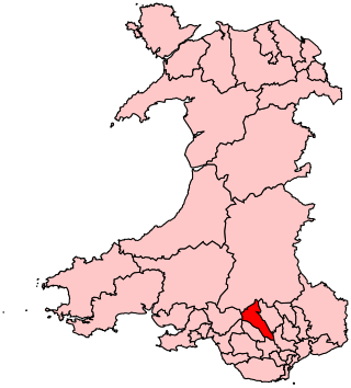
Rhondda Cynon Taf is a county borough in the south-east of Wales. It consists of five valleys: the Rhondda Fawr, Rhondda Fach, Cynon, Taff and Ely valleys, plus a number of towns and villages away from the valleys. Results from the 2011 census showed 19.1% of its 234,410 residents self-identified as having some ability in the use of the Welsh language. The county borough borders Merthyr Tydfil County Borough and Caerphilly County Borough to the east, Cardiff and the Vale of Glamorgan to the south, Bridgend County Borough and Neath Port Talbot to the west and Powys to the north. Its principal towns are - Aberdare, Llantrisant with Talbot Green and Pontypridd, with other key settlements/towns being - Maerdy, Ferndale, Hirwaun, Llanharan, Mountain Ash, Porth, Tonypandy, Tonyrefail and Treorchy.

Abercynon, is both a village and a community in the Cynon Valley within the unitary authority of Rhondda Cynon Taf, Wales. The community comprises the village and the districts of Carnetown and Grovers Field to the south, Navigation Park to the east, and Glancynon to the north.

Rhydyfelin is a large village and part of the community of Pontypridd Town, about two miles to its south east of Pontypridd, in the county borough of Rhondda Cynon Taf. It is on the eastern bank of the River Taff close to the A470, and historically was in the parish of Eglwysilan.

Ynyshir is a village and community located in the Rhondda Valley, within Rhondda Cynon Taf, South Wales. The name of the village means "long island" in Welsh and takes its name from a farm in the area, falling within the historic parishes of Ystradyfodwg and Llanwynno (Llanwonno). The community of Ynyshir lies between the small adjoining village of Wattstown and the larger town of neighbouring Porth.
Cynon Valley is a constituency represented in the House of Commons of the UK Parliament since 2019 by Beth Winter of the Labour Party.

Pontypridd is a constituency represented in the House of Commons of the UK Parliament since 2019 by Alex Davies-Jones of the Labour Party.
Pontyclun is a village and community located in the county borough of Rhondda Cynon Taf, Wales. Like the surrounding towns, it has seen a sharp increase in its population in the last ten years as people migrate south from the South Wales Valleys and west from the capital city of Cardiff.

Upper Boat is a village on the southernmost outskirts of the town of Pontypridd, within the electoral ward of Hawthorn, Rhondda Cynon Taf, Wales, and comprises part of the Treforest Industrial Estate. Historically part of Glamorgan, it fell within the parish of Eglwysilan.

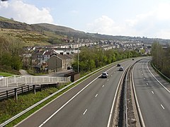
The A4059 road is a single-carriageway north–south road that runs between the A470 at Brecon Beacons National Park and the A470 at Abercynon.
Hawthorn is a village and electoral ward within the community of the town of Pontypridd in the County Borough of Rhondda Cynon Taf, located 10 miles north west of Cardiff, the capital city of Wales. Historically this fell within the parish of Eglwysilan within Mid Glamorgan.

Cilfynydd is a village in the county borough of Rhondda Cynon Taf, Wales, a mile from the South Wales Valleys town of Pontypridd, and 13 miles north of the capital city, Cardiff. Cilfynydd is also an electoral ward for the county council and Pontypridd Town Council.

The Old Bridge, which is now also known as the William Edwards Bridge or Pontypridd Bridge, was originally known as the New Bridge or Newbridge, is an arched single-span footbridge that spans the River Taff at Pontypridd in Wales. The bridge was built by William Edwards and was completed in 1756. The bridge now has statutory protection as a scheduled ancient monument and is grade I listed.

Graigwen is the name of the large hill and the village or district located thereon, sited to the north of Pontypridd town centre and south of Glyncoch and Ynysybwl in the county borough of Rhondda Cynon Taf, Wales, and within the ancient parish of Llanwonno (Llanwynno). It falls within the Rhondda and Pontypridd Town electoral wards, and comprises the sub-districts of Pantygraigwen, Penygraigwen, the Whiterock Estate, and Lanwood. It is also bounded by the districts of Pwllgwaun and Hopkinstown.

Ynysboeth is a local community within the Mountain Ash (Aberpennar) postal district of the Cynon Valley in the County Borough of Rhondda Cynon Taf, South East Wales.

Coedpenmaen (Coed-Pen-Maen) is a subdistrict of the Pontypridd town district and ward of Trallwng (Trallwn), Rhondda Cynon Taf, South Wales. It also comprises Pontypridd Common or as it is sometimes referred to 'Coedpenmaen Common'. The boundaries between the residential areas of Coedpenmaen and Trallwn themselves are blurred. Just beyond the Common on the way to the adjoining village of Glyntaff is the aptly named small village of Pentrebach.

Graig is a historic district of the town of Pontypridd, Rhondda Cynon Taf, South Wales. It is also the name of an electoral ward for the town and county councils.

Trallwn is the name of the ward and district within the town of Pontypridd, Rhondda Cynon Taf, South Wales, sited along the banks of the River Taff and falling within the historic parish of Eglwysilan. Trallwn comprises the subdistricts of Coedpenmaen (Coed-Pen-Maen), Ynysangharad and Pontypridd Common. Until recently Trallwn was also home to the famous Brown Lenox (Newbridge) Chain & Anchor Works at Ynysangharad, which was recently demolished. Also at Ynysangharad are some of the last remains of the Glamorganshire Canal which was used to transport coal and iron from the South Wales Valleys to the city of Cardiff. In addition Ynysangharad is also home to Pontypridd's War Memorial Park - Ynysangharad Park.

Pontcynon is a small village of around 200 households within the Cynon Valley in the County Borough of Rhondda Cynon Taf, Wales, near Abercynon. Most of the village consists of terraced housing fronting the B4275 Abercynon Road; but also consists of the adjoining streets of Pontcynon Terrace, Vale View and Cemetery Road.
Cilfynydd railway station served the village of Cilfynydd, in the historical county of Glamorganshire, Wales, from 1900 to 1932 on the Llancaiach Branch.