Treorchy

Last updated

Treorchy
Treorchy-6760698615 o.jpg
Rhondda Cynon Taf UK location map.svg
Red pog.svg
Treorchy
Location within Rhondda Cynon Taf
Population7,681 (Mid-2017 Estimate) [1]
OS grid reference SS955965
Principal area
Preserved county
Country Wales
Sovereign state United Kingdom
Post town TREORCHY
Postcode district CF42
Dialling code 01443
Police South Wales
Fire South Wales
Ambulance Welsh
UK Parliament
Senedd Cymru – Welsh Parliament
List of places
UK
Wales
Rhondda Cynon Taf
51°39′34″N3°30′20″W / 51.6594°N 3.5055°W / 51.6594; -3.5055

Treorchy (Welsh : Treorci; Loudspeaker.svg Welsh pronunciation ) is a town and community (and electoral ward) in Wales. Once a mining town, it retains such characteristics. Situated in the county borough of Rhondda Cynon Taf in the Rhondda Fawr valley. Treorchy is also one of the 16 communities of the Rhondda. It includes the villages of Cwmparc and Ynyswen.

Contents

History

Prior to industrialisation, most of the land was owned by one of the great families of Glamorgan with Treorchy coming under the domain of the Marquess of Bute Estate. [2] The discovery of coal transformed the area. The period following 1851 saw Treorchy becoming an industrial town. The town grew around the coal mining industry during the late 19th and early 20th century, but by the end of the 20th century all the local pits had closed, creating an economic downturn in the community.

Treorchy had been established when the Abergorki Colliery, situated in Cwm Orci to the north, was opened as a level in 1859 by a Mr Huxham, a former manager of the Bute Merthyr Colliery. This was sold to J. H. Insole of Cymmer in 1862. [3] The first deep mine in Treorchy was sunk in the 1860s by David Davies of Llandinam who would later own the Ocean Coal Company. [4] The initial development of the town was linear, based on the main road through the valley, but by 1875 a grid pattern of streets was emerging. [3]

Language

The pre-industrial Rhondda community was Welsh-speaking, and the Welsh language continued to be widely spoken in the valley and in the upper villages of the Rhondda until the mid-twentieth century. The original migrants to the Rhondda were from rural Wales but later a higher proportion came from England. In 1901 64.4% of the population of the Rhondda Urban District were recorded as Welsh-speaking but this proportion fell to 56.6% by 1911. [5]

Ysgol Gymraeg Ynyswen, a Welsh-medium primary school, is situated in the nearby village of Ynyswen. Established in 1950, it was the first Welsh-medium school in the Rhondda. It serves Treorchy and the surrounding villages, including Treherbert, Cwmparc, Penyrenglyn and Blaencwm.

Governance

The Treorchy electoral ward is coterminous with the borders of the Treorchy community and elects three county councillors to Rhondda Cynon Taf County Borough Council. Since 1995 representation has been by either the Labour Party or Plaid Cymru. Since 2008 the ward has had three Plaid Cymru representatives. [6] [7]

A 2018 review of electoral arrangements by the Local Democracy and Boundary Commission for Wales would see Treorchy's representation reduced from three to two councillors. The proposals would take effect from the 2022 council elections. [8]

Economy

After being a town whose employment relied almost entirely on coal mining in the Abergorki, Tylecoch, Parc and Dare collieries, [9] by the end of the 1970s all of these collieries had closed. [9] Treorchy became a commuter village, with the working population seeking employment in the larger towns and cities nearby, such as Cardiff and Bridgend. [10] Employment in Treorchy is now mostly in retail. [10]

In 2020, Treorchy was named by the Great British High Street Awards as the UK High Street of the Year, succeeding 2019 winner and fellow Welsh town Crickhowell. [11] It was praised for the number of independent shops in the town, and for organising a number of events, from Christmas parades to arts festivals, as well as a gay pride gathering which was a first for the area. [11] The Guardian reported that the town has grown its chamber of trade from 30 members to 120, and nearly 30 businesses have opened in recent years, producing an occupancy rate of 96%. [11] The town has a number of cafes, pubs, and shops on its high street. [11]

Religion

In its early days as an industrial settlement, Treorchy was considered a nonconformist stronghold, with many chapels, the largest of which was Noddfa, a Welsh Baptist chapel which could seat upwards of a thousand people and which had a proud choral tradition.

Education

Treorchy has two main schools: Treorchy Primary School and Treorchy Comprehensive. The primary school is not on the original site of Treorchy Boys and Treorchy Girls schools, but is built 100m further along Glyncoli Road. It is built to the original plans used on many of the older schools in the upper Rhondda.

Treorchy Comprehensive school was built on the old site of the Tylecoch colliery. Its western athletics track was named the "Red Ash", being the remnants of the mine shaft. This was removed in 2006 to build an astroturf sportsfield. The school is officially 500m from the main gate to the rear gate, and runs from Chepstow Road, Cwmparc, to the Tylecoch Bridge, Treorchy.

Transport

Bwlch-y-Clawdd Road and Treorchy Bwlch-y-Clawdd Road and Treorchy - geograph.org.uk - 1078775.jpg
Bwlch-y-Clawdd Road and Treorchy

The A4061 over the Bwlch y Clawdd Pass leads to Bridgend, via the Ogmore Vale, and to Maesteg and Port Talbot. Within the Rhondda Fawr Valley, the A4061 runs northwards to the top of the valley at Treherbert and ultimately, Hirwaun. The route on the A4058 southwards follows the valley's course to Llwynypia, Tonypandy, Porth and Pontypridd to join the A470 for Cardiff.

Treorchy railway station is located on the Rhondda Line, with regular services to Treherbert and Cardiff Central run by Transport for Wales.

Treorchy is served by buses operated by Stagecoach running to Blaenrhondda, Blaencwm, Treherbert, Tonypandy, Porth, Pontypridd and Caerphilly. On summer Sundays, Veolia provides a service to Bridgend (via the Ogmore Valley) and Brecon.

Culture

The Parc and Dare Hall Parc and Dare Hall.jpg
The Parc and Dare Hall

Attractions in the town include the Parc and Dare Hall, home of the Treorchy Male Choir and the Parc and Dare band. [12] The hall also provides entertainment as a venue for cinema, theatre and pantomime, and for school eisteddfodau and other performances.

Treorchy hosted the National Eisteddfod in 1928, the only time the event has been held in the Rhondda.

Sport

Treorchy RFC is the rugby union club, nicknamed the Zebras.

Treorchy also has 6 tennis courts, situated in Ystradfechan Park, and is the home of the Rhondda Lawn Tennis Club.

Upper Rhondda Cricket Club play on Ystradfechan Fields in Treorchy. The club was founded in 2002 when Blaenrhondda CC and Treorchy CC merged, they also have a women's side which was the first women's cricket team in the Rhondda when they started in 2019.

Notable people

See Category:People from Treorchy

Related Research Articles

<span class="mw-page-title-main">Rhondda Cynon Taf</span> County borough in Wales

Rhondda Cynon Taf is a county borough in the south-east of Wales. It consists of five valleys: the Rhondda Fawr, Rhondda Fach, Cynon, Taff and Ely valleys, plus a number of towns and villages away from the valleys. Results from the 2011 census showed 19.1% of its 234,410 residents self-identified as having some ability in the use of the Welsh language. The county borough borders Merthyr Tydfil County Borough and Caerphilly County Borough to the east, Cardiff and the Vale of Glamorgan to the south, Bridgend County Borough and Neath Port Talbot to the west and Powys to the north. Its principal towns are - Aberdare, Llantrisant with Talbot Green and Pontypridd, with other key settlements/towns being - Maerdy, Ferndale, Hirwaun, Llanharan, Mountain Ash, Porth, Tonypandy, Tonyrefail and Treorchy.

<span class="mw-page-title-main">Tonypandy</span> Human settlement in Wales

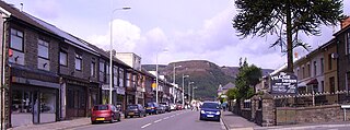
Tonypandy is a town, community and electoral ward located in the county borough of Rhondda Cynon Taf, within the historic county boundaries of Glamorgan, Wales, lying in the Rhondda Fawr Valley. A former industrial coal mining town, the town was the scene of the 1910 Tonypandy riots.

<span class="mw-page-title-main">Llwynypia</span> Human settlement in Wales

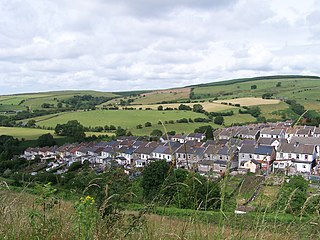
Llwynypia is a village and community in Rhondda Cynon Taf, Wales, near Tonypandy in the Rhondda Fawr Valley. Before 1850 a lightly populated rural farming area, Llwynypia experienced a population boom between 1860 and 1920 with the sinking of several coal mines after the discovery of large coal deposits throughout the Rhondda Valleys.

<span class="mw-page-title-main">Rhondda (UK Parliament constituency)</span> Parliamentary constituency in the United Kingdom, 1974 onwards

Rhondda is a constituency represented in the House of Commons of the UK Parliament since 2001 by Chris Bryant of the Labour Party.

<span class="mw-page-title-main">Rhondda</span> Urban area and district in South Wales

<span class="mw-page-title-main">Treherbert</span> Human settlement in Wales

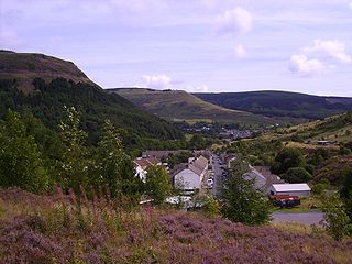
Treherbert is a village and community situated at the head of the Rhondda Fawr valley in the county borough of Rhondda Cynon Taf, Wales. Historically part of Glamorgan, Treherbert is a former industrial coal mining village which was at its economic peak between 1850 and 1920. Treherbert is the upper most community of the Rhondda Fawr and encompasses the districts of Blaencwm, Blaenrhondda, Tynewydd and Pen-yr-englyn.

<span class="mw-page-title-main">Treherbert railway station</span> Railway station in Rhondda Cynon Taf, Wales

Treherbert railway station serves the village of Treherbert in Rhondda Cynon Taf, Wales. It is the northern terminus of the Rhondda Line, 23 miles (37 km) north west of Cardiff Central.

<span class="mw-page-title-main">Dinas Rhondda</span> Human settlement in Wales

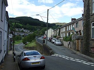
Dinas is a village near Tonypandy in the county borough of Rhondda Cynon Taf, Wales. Dinas is often referred to as Dinas Rhondda to avoid confusion with Dinas Powys in the Vale of Glamorgan. The word dinas in Modern Welsh means "city", but here it means "hill fort".

<span class="mw-page-title-main">Clydach Vale</span> Village in Rhondda Cynon Taf, Wales

Clydach Vale is a village in the community of Cwm Clydach, northwest of Tonypandy in the county borough of Rhondda Cynon Taf, within the Rhondda Valley, Wales. It is named for its situation on the Nant Clydach, a tributary of the River Rhondda. The village is deemed part of the Tonypandy built-up area by the Office for National Statistics and comes under the Tonypandy post town.

<span class="mw-page-title-main">Cwmparc</span> Human settlement in Wales

Cwmparc is a village and a district of the community of Treorchy, in the Rhondda Valley, Wales.

<span class="mw-page-title-main">Trealaw</span> Human settlement in Wales

Trealaw is a long village, also a community and electoral ward in the Rhondda Valley, Rhondda Cynon Taf, Wales. It stretches over two miles from the junction of Cemetery Road and Brithweunydd Road in the east, to the junction of Ynyscynon Road and Partridge Road to the northwest.

<span class="mw-page-title-main">A4061 road</span> Mountain pass road in Wales

The A4061 is the main road linking Bridgend with Hirwaun via the Ogmore and Rhondda Valleys in South Wales. It is a mix of streets connecting former mining communities, and mountain passes built as relief work for unemployed miners.

<span class="mw-page-title-main">Geraint Davies (Plaid Cymru politician)</span>

Geraint Rhys Davies is a Plaid Cymru Welsh politician. He was the National Assembly for Wales Member for Rhondda from 1999 to 2003.

<span class="mw-page-title-main">Gilfach Goch</span> Human settlement in Wales

Gilfach Goch is a community, electoral ward and small former coal mining village mostly in the Borough of Rhondda Cynon Taf, south Wales, near the larger community of Tonyrefail. Some areas in the North Western part of the village lie within Bridgend County Borough. It is situated in the Cwm Ogwr Fach between the Cwm Ogwr Fawr to the west and the Cwm Rhondda to the east.

<span class="mw-page-title-main">Blaencwm</span> Human settlement in Wales

Blaencwm is a village in the county borough of Rhondda Cynon Taf, Wales, lying at the head the Rhondda Fawr valley. Two collieries were opened here during the Industrial Revolution, the Dunraven Colliery in 1865 and the Glenrhondda Colliery in 1911. Both had closed by 1966 and the sites have since been landscaped, leaving little trace of their industrial past. It is in the historic county of Glamorgan.

<span class="mw-page-title-main">Nant-y-moel</span> Human settlement in Bridgend County Borough, Wales

Nant-y-moel or Nantymoel[nant ə mɔi̯l] is a village and includes the formerly separate village of Pricetown in the county borough of Bridgend, Wales on the River Ogmore, and is one of the constituent villages of the Ogmore Valley. It is bordered by the village of Wyndham to the south and by the Bwlch y Clawdd mountain to the north.

Tynewydd is a village located in the County Borough of Rhondda Cynon Taf, south Wales. With Treherbert, Blaencwm, Blaenrhondda and Pen-yr-englyn it is part of a community of Treherbert. The village lies in the former industrial coal mining area at the head of Rhondda Fawr, the larger of the Rhondda Valleys.

<span class="mw-page-title-main">Graig, Pontypridd</span> Human settlement in Wales

Graig is a historic district of the town of Pontypridd, Rhondda Cynon Taf, South Wales. It is also the name of an electoral ward for the town and county councils.

The Rhondda & District League is a football league covering the Rhondda and surrounding areas in South Wales. The leagues are at the seventh and eighth levels of the Welsh football league system.

References

  1. "Population estimates for Parishes in England and Wales, mid-2002 to mid-2017". Office for National Statistics (ONS) . Retrieved 8 July 2019.
  2. "Our Past". RCT Library Services. Retrieved 27 January 2014.
  3. 1 2 "Historic Landscape". Glamorgan-Gwent Archaeological Trust. Retrieved 28 January 2014.
  4. The Welsh Academy Encyclopaedia of Wales. John Davies, Nigel Jenkins, Menna Baines and Peredur Lynch (2008) pg750 ISBN   978-0-7083-1953-6
  5. Jones. Statistical Evidence. p. 44.
  6. Rhondda Cyon Taff County Borough Council Election Results 1995-2012, The Election Centre. Retrieved 27 October 2018.
  7. County Borough Council Elections 2017, Rhondda Cynon Taf County Borough Council. Retrieved 27 October 2018.
  8. Lewis, Anthony (30 August 2018). "The number of electoral council wards in Rhondda Cynon Taf could be cut for 2022 election". Wales Online. Retrieved 27 October 2018.
  9. 1 2 "The Rhondda Main". www.ggat.org.uk. 2 February 2014. Archived from the original on 16 September 2016. Retrieved 24 January 2020.
  10. 1 2 Cook, Jane (1 November 2007). "Rhondda Cynon Taf County Borough Council - Local Development Plan (2006-2021) - Record Of Development Of Preferred Strategy" (PDF). Rhondda Cynon Taf County Borough Council. Archived (PDF) from the original on 24 January 2020. Retrieved 24 January 2020.
  11. 1 2 3 4 Morris, Steven (24 January 2020). "'It came out of adversity': how Treorchy became UK's best high street". The Guardian. ISSN   0261-3077 . Retrieved 24 January 2020.
  12. The Parc & Dare Band at brassbands.co.uk

Bibliography