Tonteg

Last updated • 3 min readFrom Wikipedia, The Free Encyclopedia

Tonteg
Tonteg Park viewed from Cedar Crescent - geograph.org.uk - 511136.jpg
Rhondda Cynon Taf UK location map.svg
Red pog.svg
Tonteg
Location within Rhondda Cynon Taf
Population4,098 (2011 ward) [1]
Community
Principal area
Preserved county
  • Mid Glamorgan
Country Wales
Sovereign state United Kingdom
Post town Pontypridd
Postcode district CF38
Police South Wales
Fire South Wales
Ambulance Welsh
UK Parliament
Senedd Cymru – Welsh Parliament
List of places
UK
Wales
Rhondda Cynon Taf
51°34′04″N3°18′29″W / 51.5679°N 3.3080°W / 51.5679; -3.3080

Tonteg is a village in Rhondda Cynon Taf in South Wales. It is 4 miles (6.4 km) from Pontypridd, 9 miles (14.5 km) north west of Cardiff and 4 miles (6.44 km) north east of Llantrisant. The village is within the community of Llantwit Fardre. Tonteg is to the north west of the Garth Mountain, on the west side of the River Taff valley, at the top of a hill known locally as Powerstation Hill. The hill gets its name from the Upper Boat power station which was situated at the bottom of the hill until it was demolished in 1972. Tonteg is next to Church Village and the boundaries between the two villages are blurred. A significant part of the Treforest Industrial Estate falls within the Willowford area of Tonteg.

Contents

Toponymy

The name of the village occurs in a number of forms: Tonteg, Ton teg, Ton-teg and on some older maps as Ton-têg or Twyn-teg. Tonteg is now seen on the village sign, however some other signs say Ton-Teg. The name means "Beautiful hill" when translated from Welsh, deriving not from the Welsh for "wave" (ton) as might be thought, but rather from the word "twyn". [2] Indeed, a farm on the Black Road above the nearby Church Village is named Dan-y-twyn ("Beneath the hill"). It could also be related to the toponym ton as seen in Tonna.

Castle/Motte

The village has a fairly well preserved 12th-century motte castle with an intact moat called Tomen-Y-Clawdd [3] or Coed-Y-Twr. [4] To locals this fort situated in Ffordd Gerdinan is commonly known as the Monkey Tump [5]

Hospital

Tonteg Hospital is situated north of the village, now surrounded by housing estates. It was originally an isolation hospital treating contagious diseases. Nowadays it provides mental health care and other services. [6] No emergency services are provided.

The Priory Hospital Church Village is an adult female hospital specialising in learning disabilities and mental healthcare. [7]

Schools

Gwauncelyn Primary School [8] serves the local community.

Shopping

Two main areas of local businesses exist along Main Road through the village and in the center of one of the housing estates (Cardigan Close area). Tonteg no longer has a post office.

Transport

There are bus services to Beddau, Cardiff, Pontypridd, Talbot Green and Royal Glamorgan Hospital. [9]

Tonteg used to have at differing times two stations – both called Tonteg Halt railway station – on two former railway lines that ran nearby; Barry Railway and the Llantrisant and Taff Vale Junction Railway. After 1930 the original Tonteg Halt was moved to Tonteg Junction after track rationalisation; the name Tonteg Halt was used for this station.

The existence of the railways in the area around Power Station Hill has been obliterated by the Church Village bypass (described below), though some remnants exist between Tonteg and Treforest and to the south of the village towards Church Village.

There existed plans for a new station to be built on the remaining Pontypridd-Cardiff line between Treforest and Treforest Estate to serve the village, although its location would have been at the bottom of Power Station Hill and access to the village difficult.[ citation needed ]

Bypass

Rhondda Cynon Taf, the local authority, has constructed a bypass to reduce traffic congestion on the A473, Pontypridd to Bridgend (Welsh : Penybont ar Ogwr) road, at Tonteg, Church Village (Welsh : Pentre'r Eglwys) and Llantwit Fardre (Welsh : Llanilltud Faerdref). The Church Village bypass, as it is known, is built as a single carriageway, with crawler and overtaking lanes around roundabouts and was completed in Autumn 2010. [10] [11]

Governance

Tonteg is represented on Rhondda Cynon Taf County Borough Council by two county councillors from the electoral ward of Tonteg. [12] The ward comprises the eastern strip of the Llantwit Fardre community, including the Tonteg village, Treforest Industrial Estate in the north and Gedrys Farm in the south. [13] A 2018 review of electoral arrangements, if accepted, would see a decrease in the number of councillors to one, effective from the 2022 council elections. [14]

Tonteg is also the name of a community ward for Llantwit Fardre Community Council, electing three of the thirteen community councillors. [15]

Related Research Articles

<span class="mw-page-title-main">Pontypridd</span> Town in Wales

Pontypridd, colloquially referred to as Ponty, is a town and a community in Rhondda Cynon Taf, South Wales, approximately 10 miles north west of Cardiff city centre.

<span class="mw-page-title-main">Rhondda Cynon Taf</span> County borough in Wales

Rhondda Cynon Taf is a county borough in the south-east of Wales. It consists of five valleys: the Rhondda Fawr, Rhondda Fach, Cynon, Taff and Ely valleys, plus several towns and villages away from the valleys.

<span class="mw-page-title-main">Treforest</span> Suburban village in Pontypridd, Wales

Treforest is a village in the south-east of Pontypridd, in the county borough of Rhondda Cynon Taf, Wales. It is situated in the Treforest electoral ward, along with the village of Glyntaff. It is part of the Pontypridd Town community. Treforest runs along the west bank of the River Taff, while Glyntaff runs along its east bank.

<span class="mw-page-title-main">Abercynon</span> Village and community in Wales

Abercynon is a village and community in the Cynon Valley within the unitary authority of Rhondda Cynon Taf, Wales. The community comprises the village and the districts of Carnetown and Grovers Field to the south, Navigation Park to the east, and Glancynon to the north.

<span class="mw-page-title-main">Rhydyfelin</span> Human settlement in Wales

Rhydyfelin is a large village and part of the community of Pontypridd Town, about two miles to its south east of Pontypridd, in the county borough of Rhondda Cynon Taf. It is on the eastern bank of the River Taff close to the A470, and historically was in the parish of Eglwysilan.

<span class="mw-page-title-main">Pontypridd (UK Parliament constituency)</span> Parliamentary constituency in the United Kingdom, 1918 onwards

Pontypridd is a constituency represented in the House of Commons of the UK Parliament since 2019 by Alex Davies-Jones of the Labour Party.

<span class="mw-page-title-main">Beddau</span> Human settlement in Wales

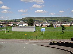
Beddau is a large former mining village situated within the South Wales Valleys around 1.5 miles (2.4 km) from Llantrisant and 4 miles (6.4 km) from the larger town of Pontypridd in the county borough of Rhondda Cynon Taf, South Wales.

<span class="mw-page-title-main">Treforest railway station</span> Railway station in Rhondda Cynon Taf, Wales

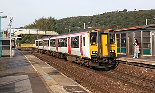
Treforest railway station is a railway station serving the village of Treforest, Rhondda Cynon Taf, Wales. It is located on the Merthyr Line and the Rhondda Line 18 km north west of Cardiff Central. Passenger services are provided by Transport for Wales.

<span class="mw-page-title-main">Taff-Ely</span> Former district of Mid Glamorgan, Wales

Taff-Ely was a local government district with borough status in Wales from 1974 to 1996.

<span class="mw-page-title-main">Talbot Green</span> Human settlement in Wales

Talbot Green is a town just north of the M4 motorway, in the County Borough of Rhondda Cynon Taf, Wales in the United Kingdom. The town is part of Llantrisant Community Council.

<span class="mw-page-title-main">A473 road</span> Road in Wales

The A473 is a main road linking Pontypridd with Bridgend in Wales.

Llantwit Fardre is a large village and community situated on the A473, Pontypridd to Bridgend, road near the Welsh towns of Pontypridd and Llantrisant. Llantwit Fardre is also the name of the old parish and the community area that takes in the villages of Llantwit Fardre, Tonteg and Church Village. It is in the county of Rhondda Cynon Taf.

<span class="mw-page-title-main">Church Village</span> Village in Rhonda Cynon Taf, Wales

Church Village is a large village in the historic parish and community of Llantwit Fardre, located within the Taff Ely district of the County Borough of Rhondda Cynon Taf in Wales. The village is centrally located being around 4 miles (6.4 km) from the local principal towns of Llantrisant to the southwest and Pontypridd to the north and is situated approximately 8 miles northwest of Cardiff city centre.

<span class="mw-page-title-main">Afon Clun</span> River in Wales

Afon Clun is a 14-mile (23 km) long tributary of the River Ely, in the counties of Cardiff and Rhondda Cynon Taf, Wales. Its bedrock is predominantly of sandstone. Beginning on the western slope of The Garth the river is fast-flowing, in clear shallow water with a hard substrate, flowing to the south of Llantrisant and generally west to its confluence with the River Ely at Pontyclun, falling 715 feet (218 m) over its course.

The Llantrisant and Taff Vale Junction Railway was a railway company that constructed a standard gauge line in South Wales, connecting Llantrisant and the Taff Vale Railway near Treforest. It ran through thinly populated country, and linked to a number of iron mines, collieries and other mineral sites. It opened in stages in 1863 and 1864. In 1865 through passenger trains from the Cowbridge Railway ran over the line, to Pontypridd, although for some time there were no passenger stations on its own network. At the Llantrisant end, it was reliant on broad gauge railway companies which were not always friendly to it. The company leased its line to the Taff Vale Railway in 1870.

<span class="mw-page-title-main">Tonteg Halt railway station</span> Former railway station in Wales

Tonteg Halt refers to two railway stations serving the township of Tonteg in Rhondda Cynon Taf, Wales. They were located on the Llantrisant and Taff Vale Junction Railway and latterly on the Barry Railway under the Great Western Railway.

References

  1. "Ward population 2011" . Retrieved 17 November 2015.
  2. "Enwau lleoedd yn Ystradyfodwg.|1900-04-14|The Rhondda Leader - Welsh Newspapers". Papurau Newydd Arlein. National Library of Wales. Retrieved 5 January 2016.
  3. The Welsh Academy Encyclopaedia of Wales. John Davies, Nigel Jenkins, Menna Baines and Peredur Lynch (2008) pg 507 ISBN   978-0-7083-1953-6
  4. "Coed-y-twr Motte (300137)". Coflein. RCAHMW . Retrieved 14 October 2021.
  5. "Monkey Tump and Dinky Poo make it onto new map of Wales". Wales Online. 22 July 2012. Retrieved 14 October 2021.
  6. "Rhondda Cynon Taf Community Information". Archived from the original on 28 September 2011. Retrieved 27 January 2011.
  7. "Llantwit Fardre Community Council | History". www.llantwitfardrecommunitycouncil.org. Retrieved 26 April 2022.
  8. "Gwauncelyn Primary School, Tonteg, Pontypridd :: Home Page". Archived from the original on 14 April 2010.
  9. "Local bus, coach and rail information for Abergavenny". www.carlberry.co.uk. Retrieved 14 November 2023.
  10. "Church Village Bypass - Web Online". Church Village Bypass website. Rhondda Cynon Taf CBC, Costain and the Welsh Assembly Government. 2009. Archived from the original on 22 June 2009. Retrieved 17 April 2009.
  11. "WalesOnline - News - South Wales Valleys - Pontypridd & Llantrisant - Safety worries discounted as bypass work begins". Wayne Nowaczyk, Pontypridd Observer. Media Wales Ltd. 11 December 2008. Retrieved 17 April 2009.
  12. "The County Borough of Rhondda Cynon Taff (Electoral Arrangements) Order 1998". Legislation.gov.uk. 23 November 1998. Retrieved 17 February 2019.
  13. "Election maps". Ordnance Survey . Retrieved 17 February 2019.
  14. Anthony Lewis (30 August 2018). "The number of electoral council wards in Rhondda Cynon Taf could be cut for 2022 election". Wales Online. Retrieved 17 February 2019.
  15. "Council Members". Llantwit Fardre Community Council. Retrieved 22 June 2022.