Garth Hill

Last updated

The Garth
Mynydd y Garth (Welsh)
Garth hill (geograph 6339048).jpg
Highest point
Elevation 307 m (1,007 ft)
Prominence 211 m (692 ft)
Listing Marilyn, County top
Coordinates 51°32′35.66″N3°17′41.53″W / 51.5432389°N 3.2948694°W / 51.5432389; -3.2948694 Coordinates: 51°32′35.66″N3°17′41.53″W / 51.5432389°N 3.2948694°W / 51.5432389; -3.2948694
Geography
Wales relief location map.jpg
Red triangle with thick white border.svg
The Garth
Location of The Garth in Wales
LocationCardiff, Wales
OS grid ST103835

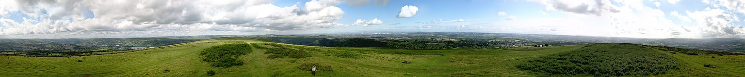
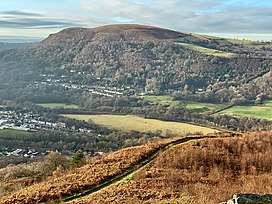
Garth Hill (usually called The Garth, or Garth Mountain; Welsh : Mynydd y Garth) is a hill located in between the communities of Llantwit Fardre and Pentyrch in Wales. The Garth can be seen from nearly the whole of the city of Cardiff and the Taff Valley, and on a sunny, clear day as far as Weston-super-Mare across the Bristol Channel in southwest England. It lies adjacent to the Taff Vale with the village of Pentyrch on one side and looks down onto the small villages of Gwaelod-y-Garth and Taff's Well. The Garth has a number of tumuli on its top. [1] These are burial sites dating from the early to middle Bronze Age. [2]

Fine views of Cardiff and the Taff valley are obtained from the prominent crag. [3] The Garth has a sister hill, the Lesser Garth. The Lesser Garth is of limestone, which is extensively quarried with much of the hill removed; it was also formerly mined for iron ore. [4] The valley between the two is eroded in softer coal measures, shales in the main, while the Garth is formed of the resistant Pennant sandstone [5] formation.

Until the 19th century, the valley and the lower slopes of the Garth facing Taff's Well were full of small coal mines which fed the ironworks below in the River Taff valley, opposite Taff's Well. There is now little trace of these although Y Lan Colliery has recently had its portal partly restored as a memorial to an explosion in 1875. A cleared path now leads to this, near the primary school. The access road to Pentyrch village, Heol Goch, runs between the main and lesser Garth.

Christopher Monger, a native of Taff's Well, wrote the novel The Englishman who Went up a Hill but Came down a Mountain . The location of the fictional Ffynnon Garw above the writer's home village suggests that it is the Garth and the mound on which the trigonometrical point stands is a Bronze Age burial mound. Monger adapted the story for the 1995 film of the same title on which he was the director. The popularity of the film has resulted in a stream of visitors climbing to the summit of Garth Mountain to view the location.

Garth Hill Panoramic View.jpg
Panoramic view from The Garth

Related Research Articles

<span class="mw-page-title-main">Rhondda Cynon Taf</span> County borough in Wales

Rhondda Cynon Taf is a county borough in the south-east of Wales. It consists of five valleys: the Rhondda Fawr, Rhondda Fach, Cynon, Taff and Ely valleys, plus a number of towns and villages away from the valleys. Results from the 2011 census showed 19.1% of its 234,410 residents self-identified as having some ability in the use of the Welsh language. The county borough borders Merthyr Tydfil County Borough and Caerphilly County Borough to the east, Cardiff and the Vale of Glamorgan to the south, Bridgend County Borough and Neath Port Talbot to the west and Powys to the north. Its principal towns are - Aberdare, Llantrisant with Talbot Green and Pontypridd, with other key settlements/towns being - Maerdy, Ferndale, Hirwaun, Llanharan, Mountain Ash, Porth, Tonypandy, Tonyrefail and Treorchy.

<span class="mw-page-title-main">Monmouthshire</span> County in Wales

Monmouthshire is a county in the south-east of Wales. The name derives from the historic county of the same name; the modern county covers the eastern three-fifths of the historic county. The largest town is Abergavenny, with other towns and large villages being: Caldicot, Chepstow, Monmouth, Magor and Usk. It borders Torfaen, Newport and Blaenau Gwent to the west; Herefordshire and Gloucestershire to the east; and Powys to the north.

<span class="mw-page-title-main">Gwaelod-y-Garth</span> Village in Cardiff, Wales

Gwaelod-y-garth is a village in the community of Pentyrch, Cardiff in Wales.

<span class="mw-page-title-main">Radyr</span> Suburb of Cardiff, Wales

Radyr is an outer suburb of Cardiff, about 4 miles (6.4 km) northwest of Cardiff city centre. Radyr is part of Radyr and Morganstown Community, for which the 2011 Census recorded a population of 6,417.

<i>The Englishman who Went up a Hill but Came down a Mountain</i> 1995 film by Christopher Monger

The Englishman who Went up a Hill but Came down a Mountain is a 1995 romantic comedy film with a story by Ifor David Monger and Ivor Monger, written and directed by Christopher Monger. It was entered into the 19th Moscow International Film Festival and was screened in the Un Certain Regard section at the 1995 Cannes Film Festival.

Garth may refer to:

<span class="mw-page-title-main">Pentyrch</span> Village and community in Cardiff, Wales

Pentyrch is a village and community located on the western outskirts of Cardiff, the capital city of Wales. The village gives its name to a Cardiff local authority electoral ward, Pentyrch, which covers the village and immediate surrounding area. The Pentyrch community includes the neighbouring village of Creigiau and Gwaelod y Garth. People living in Pentyrch are commonly known as "Penterchyians".

<span class="mw-page-title-main">Taff's Well</span> Human settlement in Wales

Taff's Well is a semi-rural village, community and electoral ward located at the south easterly tip of Rhondda Cynon Taf, 6 miles (9.7 km) to the north of Cardiff, the capital city of Wales. Known locally as the 'Gates to the Valleys', it is separated from Gwaelod Y Garth by the River Taff. Taff's Well is distinguished because it contains the only thermal spring in Wales. The tepid water is thought to rise along a fault-line from the Carboniferous Limestone, in somewhat similar manner to the warm springs at Bristol and Bath. Various religious groups regard it as a spiritual site.

<span class="mw-page-title-main">Eglwyseg</span> Valley in Wales

The Eglwyseg valley is an area to the north east of Llangollen in Denbighshire, Wales; it is within the boundaries of Llantysilio Community. The name also refers to a widely scattered hamlet in the valley.

<span class="mw-page-title-main">History of Cardiff</span> The 6,000 year history of Cardiff

The history of Cardiff—a City and County Borough and the capital of Wales—spans at least 6,000 years. The area around Cardiff has been inhabited by modern humans since the Neolithic Period. Four Neolithic burial chambers stand within a radius of 10 mi (16 km) of Cardiff City Centre, with the St Lythans burial chamber the nearest, at about 4 mi (6.4 km) to the west. Bronze Age tumuli are at the summit of Garth Hill, within the county's northern boundary, and four Iron Age hillfort and enclosure sites have been identified within the City and County of Cardiff boundary, including Caerau Hillfort, an enclosed area of 5.1 ha. Until the Roman conquest of Britain, Cardiff was part of the territory of an Iron Age Celtic British tribe called the Silures, which included the areas that would become known as Brecknockshire, Monmouthshire and Glamorgan. The Roman fort established by the River Taff, which gave its name to the city—Caerdydd, earlier Caerdyf, from caer (fort) and Taf—was built over an extensive settlement that had been established by the Silures in the 50s AD.

<span class="mw-page-title-main">Afon Clun</span> River in Wales

The Afon Clun is a 14-mile (23 km) long tributary of the River Ely, in the counties of Cardiff and Rhondda Cynon Taf, Wales. Its bedrock is predominantly of sandstone. Beginning on the western slope of The Garth the river is fast-flowing, in clear shallow water with a hard substrate, flowing to the south of Llantrisant and generally west to its confluence with the River Ely at Pontyclun, falling 715 feet (218 m) over its course.

<span class="mw-page-title-main">Cribarth</span>

Cribarth, sometimes referred to as the Sleeping Giant, is a hill in the Brecon Beacons National Park located in the traditional county of Brecknockshire in southern Wales. The summit lies on the broken ridge at an elevation of 428 m (1,404 ft) at OS grid reference SN 831143. To its west is a 426-metre-high (1,398 ft) rounded top at SN 829144 which lies just to the northwest of a mile-long ridge that forms the main bulk of the hill. The ridge attains a height of 423 m (1,388 ft) at its southwest end and this spot is marked by a trig point. Both of these latter high points are adorned by Bronze Age burial cairns.

Penmoelallt or Onllwyn is a hill in the northern part of the county borough of Rhondda Cynon Taff in south Wales. It lies within the Brecon Beacons National Park and Fforest Fawr Geopark. To its east lies the deep valley of Cwm Taf and to its north a rather shallower valley in which the Nant Cadlan originates. To the west is the hill known as Mynydd-y-glog and to the south are slopes draining into the River Taff and the Afon Cynon. The hill culminates in a broken plateau with several knolls rising above the 420m contour. Its afforested nature makes it difficult to determine the precise location of its highest point but this probably lies somewhere around OS grid ref SO 003096. Older maps indicate a spot height of 1376 ft above sea level at SO 000090.

<span class="mw-page-title-main">Ynysboeth</span> Human settlement in Wales

Ynysboeth is a local community within the Mountain Ash (Aberpennar) postal district of the Cynon Valley in the County Borough of Rhondda Cynon Taf, South East Wales.

<span class="mw-page-title-main">Mynydd Merthyr</span>

Mynydd Merthyr is a broad ridge of high ground between Taff Vale and the Cwm Cynon in the Valleys region of South Wales. It forms the boundary between the unitary authorities of Rhondda Cynon Taff to the west and Merthyr Tydfil to the east.

<span class="mw-page-title-main">Mynydd Cilfach-yr-encil</span>

Mynydd Cilfach-yr-encil attains a height of 445m at OS grid reference SO 079033 making it the high point of the broad ridge of high ground between Taff Vale and Cwm Bargod in the Valleys region of South Wales. It lies within the unitary area of Merthyr Tydfil.

The geology of Monmouthshire in southeast Wales largely consists of a thick series of sedimentary rocks of different types originating in the Silurian, Devonian, Carboniferous, Triassic and Jurassic periods.

<span class="mw-page-title-main">Walnut Tree Viaduct</span> Bridge in Cardiff, South Wales

Walnut Tree Viaduct was a railway viaduct located above the southern edge of the village of Taffs Well, South Wales. Originally built to carry the Barry Railway across a narrow gorge through which the River Taff, Taff Vale Railway and Cardiff Railway passed, it was deconstructed in 1969, leaving only two of the support columns visible from the A470 road.

Hirfynydd is a 481-metre-high hill in Neath Port Talbot county borough in South Wales. A Roman road, Sarn Helen, runs along its entire northeast–southwest ridge-line, a route followed by a modern-day byway. To its west is Cwm Dulais and to its southeast is the Vale of Neath. The northern end of the ridge falls away to a broad upland vale containing the Afon Pyrddin and beyond which is the Brecon Beacons National Park.

<span class="mw-page-title-main">Mynydd y Gaer</span>

Mynydd y Gaer is a 295-metre-high hill in Bridgend County Borough in South Wales. The summit is crowned by a trig point.

References

  1. "Trig point on Tumulus on Garth Hill:: OS grid ST1083". Geograph Britain and Ireland. Retrieved 25 January 2012.
  2. "Garth Burial Mounds". Early history. Pentyrch Community Council. Retrieved 2 September 2013.
  3. "Taff Gorge from sandstone crag on Garth Hill: OS grid ST1282". Geograph Britain and Ireland. Retrieved 25 January 2012.
  4. "Taffs Well Quarry: OS grid ST1282". Geograph Britain and Ireland. Retrieved 25 January 2012.
  5. "Pennant Sandstone". A Thousand Years of Building with Stone.