This article needs additional citations for verification .(April 2024) |

The River Rhondda (Welsh : Afon Rhondda) is a river in South Wales with two major tributaries, Rhondda Fawr (meaning big Rhondda) and Rhondda Fach (meaning little Rhondda).
This article needs additional citations for verification .(April 2024) |
The River Rhondda (Welsh : Afon Rhondda) is a river in South Wales with two major tributaries, Rhondda Fawr (meaning big Rhondda) and Rhondda Fach (meaning little Rhondda).

The river has two major tributaries, the Rhondda Fawr and the Rhondda Fach (respectively, the "big" and the "little" Rhondda). Despite these names, both tributaries are of similar length. Both valleys display the U-shape cross-sections typical of glaciated valleys, having been eroded during successive ice ages. They cut deeply into the thick South Wales Coal measures which comprise sandstones and mudstones and coal seams of Carboniferous age. The whole form of the river and its surrounding urbanisation has been dominated by coal mining and the communities that grew up to exploit the rich coal seams. Much of the valley has suffered severe subsidence because of the removal of coal from beneath the valley floor. The houses and streets have subsided with the result that river levels are, in parts, higher than the surrounding houses. In order to contain the river and prevent flooding, walls have been built, sometimes across the ends of streets - these are known as "The Rhondda walls".
The Rhondda Fawr has its source on the eastern side of Craig y Llyn south of Llyn Fawr in a spring called Ffynnon y Gwalciau at an elevation of about 544m OD. [1] The main head stream, Nant Carn Moesen (or Nant Carfoesen) runs down a plateau slope for about a mile and drops steeply, joining with the Nant Garreg-lwyd and the Nant Melyn to form the Rhondda. [2] The combined waters then continue descending sharply through a mountain gorge to the foot of Pen Pych. [3] The river runs through Blaenrhondda where it is joined by the Nant y Gwair, and runs down the Rhondda Valley, (Welsh : Cwm Rhondda). The river then passes through a string of mining towns and villages including Treherbert, Treorchy, Pentre, Ton Pentre, Ystrad Rhondda, Llwynypia, Tonypandy (joined by the Nant Clydach), Dinas and Porth where it joins its sister tributary.
The Rhondda Fach rises about a mile to the east of the source of the Rhondda Fawr on the hills above Blaenrhondda in a marshy area between Mynydd Beili Glas and Mynydd Bwllfa at an elevation of 489m OD. [4] [1] The fledgling river is first contained in the Lluest-wen Reservoir before flowing down into Maerdy and then on through Ferndale, Tylorstown, Ynyshir to its confluence at Porth.
The River Rhondda flows on past Trehafod to reach its confluence with the River Taff at Pontypridd.
The mining industry had a catastrophic impact on the quality of the river with all the mine waters being pumped straight into the river with no treatment. For very long periods, probably more than a century, the river was continuously black with coal solids and little if anything could live in the river. This was compounded by the very basic sewage disposal arrangements which saw all the sewage discharged into the same river. Not until the 1970s was there real investment made in improving the sewage treatment arrangements.
Since the early 1970s the river has been steadily improving in quality largely due to the closure of all the coal mines and through the investment in sewerage and sewage treatment.

The River Afan is a river in Wales whose valley formed the territory of the medieval Lords of Afan. The Afan Valley encompasses the upper reaches of the river. The valley is traversed by the A4107 road. Settlements in the area include Cwmafan, Pontrhydyfen and Cymmer. The town of Aberavon, whose name in Welsh Aberafan means 'mouth of the Afan', grew up on the banks of the river and was later subsumed by the town of Port Talbot.
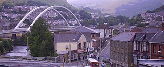
Porth is a town and a community in the county borough of Rhondda Cynon Taf, within the historic county boundaries of Glamorgan, Wales. Lying in the Rhondda Valley, it is regarded as the gateway connecting the Rhondda Fawr and Rhondda Fach valleys due to both valleys meeting at Porth. The Welsh word "porth" means "gate". Porth is a predominantly English-speaking community.

The River Ogmore is a river in South Wales that is popular with anglers. It runs generally from north to south from the Ogmore Vale and Gilfach Goch, past Bridgend and Ogmore. The River Ogmore rises at Craig Ogwr in the Ogmore Valley as the Ogwr Fawr before it links with the Ogwr Fach at Blackmill. The River Llynfi, the River Garw and finally the River Ewenny in its estuary are all tributaries of the Ogmore which flows into the sea between Ogmore-by-Sea and the Merthyr Mawr sand-dunes.

Rhondda, or the Rhondda Valley, is a former coalmining area in South Wales, historically in the county of Glamorgan. It takes its name from the River Rhondda, and embraces two valleys – the larger Rhondda Fawr valley and the smaller Rhondda Fach valley – so that the singular "Rhondda Valley" and the plural are both commonly used. The area forms part of the South Wales Valleys. From 1897 until 1996 there was a local government district of Rhondda. The former district at its abolition comprised sixteen communities. Since 1996 these sixteen communities of the Rhondda have been part of Rhondda Cynon Taf County Borough. The area of the former district is still used as the Rhondda Senedd constituency and Westminster constituency, having an estimated population in 2020 of 69,506. It is most noted for its historical coalmining industry, which peaked between 1840 and 1925. The valleys produced a strong Nonconformist movement manifest in the Baptist chapels that moulded Rhondda values in the 19th and early 20th centuries. It is also known for its male voice choirs and in sport and politics.

The River Llynfi, is one of three main tributaries of the River Ogmore.

Ystradyfodwg or Ystrad Dyfodwg was an ancient upland parish in Glamorgan, Wales. It is believed to have been named after Dyfodwg a 6th-century saint or chieftain. The parish included most of the area which would later be known as Rhondda named for the parish rivers, Rhondda Fawr and Rhondda Fach.

Rhondda was a local government district in the geographical area of the Rhondda Valley, south Wales, from 1877 until 1996, with various statuses through its history.
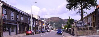
Treherbert is a village and community situated at the head of the Rhondda Fawr valley in the county borough of Rhondda Cynon Taf, Wales. Historically part of Glamorgan, Treherbert is a former industrial coal mining village which was at its economic peak between 1850 and 1920. Treherbert is the upper most community of the Rhondda Fawr and encompasses the districts of Blaencwm, Blaenrhondda, Tynewydd and Pen-yr-englyn.

The River Gwendraeth is a river in Carmarthenshire in West Wales.

Llyn Fawr is a reservoir that occupies one of a series glacial cirques that form the northern escarpment of the South Wales Coalfield uplands, overlooking the heads of the Vale of Neath and the Cynon Valley, South Wales. It is known as the site of an important hoard of weapons and tools from the late Bronze Age and early Iron Age.
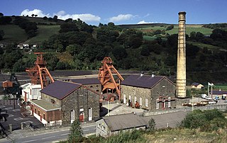
Rhondda Heritage Park, Trehafod, Rhondda, South Wales, is a tourist attraction which offers an insight into the life of the coal mining community that existed in the area until the 1980s.

Fochriw is a village in Caerphilly County Borough, Wales. It was well known for its neighbouring collieries, which employed nearly the entire local population in the early 20th century. It lies within the historic county boundaries of Glamorgan. The village appears as the backdrop on the BBC Wales sitcom High Hopes credits. The village's population was 1,250 in 2011.

Blaenrhondda is a village in the county borough of Rhondda Cynon Taf, Wales, lying at the head the Rhondda Fawr valley. Blaenrhondda is a village and is part of the community of Treherbert.
The Nant Gwys is a river flowing off the Black Mountain in Powys, Wales. Its tributaries Gwys Fawr and the Gwys Fach flow south from Banwen Gwyn and Bwlch y Ddeuwynt respectively and join forces to form the Nant Gwys proper which then flows for about 5 km / 3 mi to its confluence with the Afon Twrch at Cwm-twrch-Uchaf.
Mynydd Llangynidr is a mountain in the Brecon Beacons National Park largely in the county of Powys, south Wales. Its southern slopes extend into the northernmost parts of the county borough of Blaenau Gwent. It is named from the village of Llangynidr which sits in the valley of the River Usk to the north of it. It is essentially an undulating plateau rising in the west to a height of 557m at Garn Fawr at OS grid ref SO 123151. A secondary high point is achieved at a point marked by a trig point at SO 147159. To the north the hill overlooks the valleys of Dyffryn Crawnon and Cwm Claisfer, themselves tributary valleys of the Usk. The shallow upper valley of the Ebbw River reaches into the plateau in the southeast whilst the upper reaches of the Sirhowy Valley and its tributary the Nant Trefil define its western margins. A further tributary, the Nant Milgatw, reaches in from the south whilst the sharp edge of Rassau Industrial Estate also defines a part of its southern margin. Passing east across the B4560, the hill merges with Mynydd Llangatwg which has a similar character.
Tynewydd is a village located in the County Borough of Rhondda Cynon Taf, south Wales. With Treherbert, Blaencwm, Blaenrhondda and Pen-yr-englyn it is part of a community of Treherbert. The village lies in the former industrial coal mining area at the head of Rhondda Fawr, the larger of the Rhondda Valleys.

Mynydd Merthyr is a broad ridge of high ground between Taff Vale and the Cwm Cynon in the Valleys region of South Wales. It forms the boundary between the unitary authorities of Rhondda Cynon Taff to the west and Merthyr Tydfil to the east.
51°36′57″N3°24′39″W / 51.61591°N 3.41074°W
| Authority control databases: National |
|---|
