Llyn Fawr

Last updated

Llyn Fawr
LlynFawr.jpg
Rhondda Cynon Taf UK relief location map.jpg
Red pog.svg
Llyn Fawr
Location Rhigos, South Wales Valleys, Wales
Coordinates 51°43′11″N3°34′6″W / 51.71972°N 3.56833°W / 51.71972; -3.56833 Coordinates: 51°43′11″N3°34′6″W / 51.71972°N 3.56833°W / 51.71972; -3.56833
Lake type natural lake, reservoir
Basin  countriesUnited Kingdom
Surface area 9.8 ha (24 acres)
Surface elevation368 m (1,207 ft)

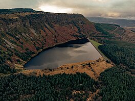
Llyn Fawr ('large lake' in Welsh) is a reservoir that occupies one of a series glacial cirques that form the northern escarpment of the South Wales Coalfield uplands, overlooking the heads of the Vale of Neath and the Cynon Valley, South Wales. It is known as the site of an important hoard of weapons and tools from the late Bronze Age and early Iron Age.

Contents

It lies on the northern flanks of Craig-y-Llyn, a mountain that is designated as a Site of Special Scientific Interest. [1] The western cirque contains Llyn Fach ('small lake'). While in government terms, it falls in the unitary authority of Rhondda Cynon Taf, in geographic terms it is actually in the Vale of Neath and its excess waters (all its water before conversion) flow into Nant Gwrelych, which flows into the River Neath at Pont Walby near Glynneath. Less than 1 km to the southeast and south lie the headwaters of the Rhondda Fawr and Rhondda Fach rivers, while 1.5 km to the southwest lie the headwaters of River Corrwg.

Drinking water reservoir

Owing to its rapid and massive industrialisation during its coalfield boom (population increasing from 951 in 1851 to 113,735 in 1901), the Rhondda Valley, which lies on the south side of the escarpment, surpassed the supply of water it could source from its own river, so in 1909 the Water Works division of Rhondda Urban District Council contracted builders to convert Llyn Fawr into a reservoir. Originally having an area of 11.927 acres (0.048 km2), [2] the lake was expanded, by the construction of a 25-foot high embankment dam and deepening of lake bed, to give a total storage volume of 200,000,000 gallons (909 megalitres). [3] With work completed in 1913 giving the new lake a surface area of 21.616 acres (0.087 km2), [4] which then was increased again to 24.75 acres (0.100 km2) sometime before 1970s. [5] The raw water supply then being pumped through a 1.25-mile long tunnel under Craig-y-Llyn to Ty'n-y-waun water treatment works, in Tynewydd, Rhondda. This tunnel is still a critical part of Welsh Water's infrastructure, supplying the majority of the water supply for the Rhondda valley. [6] Although it is subsiding due to collapsing coal working below, with water now pooling in the middle, [7] investigation is being made into either ways to stabilise it or replace it. [6]

Bronze age hoard

It was during the deepening of the lake that the Llyn Fawr Hoard was discovered between 1909 and 1912. It contains many objects from the late Bronze Age, but also a number of iron objects, notably an iron sword of the Hallstatt type. Two other iron implements were found a spear and a socketed sickle. Bronze items included two cauldrons and axeheads. The items appear to have been placed in the lake as votive offerings. The date of these items is uncertain because of the context of the finds, but the sword is thought to date from about 650 BC. It is the earliest iron object to have been discovered in Wales. The hoard gave its name to the Llyn Fawr Phase, which is the last phase of the Bronze Age in Britain. The hoard is now in the possession of Amgueddfa Cymru – Museum Wales.

Related Research Articles

<span class="mw-page-title-main">Glamorgan</span> Historic county of Wales

Glamorgan, or sometimes Glamorganshire, is one of the thirteen historic counties of Wales and a former administrative county of Wales. Originally an early medieval petty kingdom of varying boundaries known in Welsh as the Kingdom of Morgannwg, which was then invaded and taken over by the Normans as the Lordship of Glamorgan. The area that became known as Glamorgan was both a rural, pastoral area, and a conflict point between the Norman lords and the Welsh princes. It was defined by a large concentration of castles.

<span class="mw-page-title-main">Tonypandy</span> Human settlement in Wales

Tonypandy is a town, community and electoral ward located in the county borough of Rhondda Cynon Taf, within the historic county boundaries of Glamorgan, Wales, lying in the Rhondda Fawr Valley. A former industrial coal mining town, the town was the scene of the 1910 Tonypandy riots.

<span class="mw-page-title-main">River Taff</span> River in Wales which flows into Cardiff Bay

The River Taff is a river in Wales. It rises as two rivers in the Brecon Beacons; the Taf Fechan and the Taf Fawr before becoming one just north of Merthyr Tydfil. Its confluence with the River Severn estuary is in Cardiff.

<span class="mw-page-title-main">Glyderau</span>

The Glyderau are a mountain group in Snowdonia, North Wales. The name derives from the highest peaks in the range, Glyder Fawr and Glyder Fach. According to Sir Ifor Williams, the word "Glyder" derives from the Welsh word "Cludair", meaning a heap of stones.

<span class="mw-page-title-main">Glyder Fawr</span> Mountain in Snowdonia, Wales

Glyder Fawr is a mountain in Snowdonia, Wales, the highest peak in the Glyderau range at just over 1,000 metres, having had its height recalculated in 2010 using GPS. It is the fifth-highest mountain in Wales and has several walking and scrambling routes leading to its summit. According to Sir Ifor Williams, the word "Glyder" derives from the Welsh word "Gludair", meaning a heap of stones.

<span class="mw-page-title-main">Abercynon</span> Human settlement in Wales

Abercynon, is both a village and a community in the Cynon Valley within the unitary authority of Rhondda Cynon Taf, Wales. The community comprises the village and the districts of Carnetown and Grovers Field to the south, Navigation Park to the east, and Glancynon to the north.

<span class="mw-page-title-main">Rhondda</span> Urban area and district in South Wales

Rhondda, or the Rhondda Valley, is a former coalmining area in South Wales, historically in the county of Glamorgan. It takes its name from the River Rhondda, and embraces two valleys – the larger Rhondda Fawr valley and the smaller Rhondda Fach valley – so that the singular "Rhondda Valley" and the plural are both commonly used. The area forms part of the South Wales Valleys. From 1897 until 1996 there was a local government district of Rhondda. The former district at its abolition comprised sixteen communities. Since 1996 these sixteen communities of the Rhondda have been part of Rhondda Cynon Taf County Borough. The area of the former district is still used as the Rhondda Senedd constituency and Westminster constituency, having an estimated population in 2020 of 69,506. It is most noted for its historical coalmining industry, which peaked between 1840 and 1925. The valleys produced a strong Nonconformist movement manifest in the Baptist chapels that moulded Rhondda values in the 19th and early 20th centuries. It is also known for its male voice choirs and in sport and politics.

<span class="mw-page-title-main">Pontrhydyfen</span> Human settlement in Wales

Pontrhydyfen is a small village in the Afan Valley, in Neath Port Talbot county borough in Wales. The village sits at the confluence of the River Afan and the smaller Afon Pelenna, 1.8 miles (2.9 km) north of the larger village of Cwmafan and not far from the towns of Port Talbot and Neath. The views from the village are dominated by the hills of Foel Fynyddau (370 m) to the west, Moel y Fen (260 m) to the south-east and Mynydd Pen-rhys (280 m) to the north. This former coal mining community is distinguished by two large 19th-century bridges that span the valley: a railway viaduct and a former aqueduct, known in the Welsh language as Y Bont Fawr. The built-up area has a population of around 830. It is in the community of Pelenna.

<span class="mw-page-title-main">River Rhondda</span>

The River Rhondda is a river in South Wales with two major tributaries, Rhondda Fawr and Rhondda Fach.

<span class="mw-page-title-main">Rhigos</span> Human settlement in Wales

Rhigos is a small village on the saddle of higher ground between the Vale of Neath and the Cynon Valley. It was part of the old Neath Rural district Council under Glamorgan until 1974. The village then came under the jurisdiction of The Cynon Valley Borough which subsequently became Rhondda Cynon Taf, South Wales in 1996. It lies just off the old Aberdare road that was the main link between Aberdare and Glynneath, before the A465 road was extended in the 1960s. The hamlets of Cefn Rhigos and Cwm-Hwnt lie to the west of the main village.

<span class="mw-page-title-main">Black Mountain (range)</span>

The Black Mountain is a mountain range in South, Mid and West Wales, straddling the county boundary between Carmarthenshire and Powys and forming the westernmost range of the Brecon Beacons National Park. Its highest point is Fan Brycheiniog at 802 metres or 2,631 ft. The Black Mountain also forms a part of the Fforest Fawr Geopark.

<span class="mw-page-title-main">Blaengwrach</span> Human settlement in Wales

Blaengwrach is a community near Glynneath and Resolven in the county borough of Neath Port Talbot, Wales. It is also the name of an electoral ward of Neath Port Talbot county borough, which is a larger area than the Community. The principal settlement is Cwmgwrach, a village on the south side of the Neath valley, of which the eastern end is called Blaengwrach, which sometimes causes confusion.

<span class="mw-page-title-main">Craig y Llyn</span>

Craig y Llyn is a mountain situated to the south of the village of Rhigos in the Cynon Valley on the south side of the upper Vale of Neath and north of the Rhondda Valleys in South Wales; it is the highest point in the ancient kingdom and, later, county of Glamorgan (Morgannwg), and the southern Welsh coalfield plateau.

<span class="mw-page-title-main">A4061 road</span> Mountain pass road in Wales

The A4061 is the main road linking Bridgend with Hirwaun via the Ogmore and Rhondda Valleys in South Wales. It is a mix of streets connecting former mining communities, and mountain passes built as relief work for unemployed miners.

<span class="mw-page-title-main">Llyn y Fan Fach</span> Lake in Wales

Llyn y Fan Fach is a lake of approximately 10 hectares on the northern margin of the Black Mountain in Carmarthenshire, South Wales and lying within the Brecon Beacons National Park. The lake lies at an altitude of approximately 1,660 feet (510 m), immediately to the north of the ridge of the Carmarthen Fans. It is the smaller of two lakes within this mountain massif: the slightly larger Llyn y Fan Fawr is about 2 miles (3.2 km) to the east.

<span class="mw-page-title-main">Fan Hir</span>

Fan Hir is a peak at the eastern end of the Black Mountain in the Brecon Beacons National Park in southern Wales. It is a subsidiary summit of Fan Brycheiniog. It falls within the county of Powys and is also a part of the traditional area of Fforest Fawr. Its Welsh name means "long peak", a fitting description, particularly if seen from the east when its steep eastern face is seen to advantage. It is about 2.5 miles or 4 km long and faces east. Its summit is 2490 feet above sea level. Fan Hir is separated from its higher neighbour to the north-west, Fan Brycheiniog by a col known as Bwlch Giedd, where a path rises from Llyn y Fan Fawr via a stone staircase.

<span class="mw-page-title-main">Picws Du</span>

Picws Du is the second highest peak of the Carmarthen Fans in the Carmarthenshire section of the Black Mountain in the west of the Brecon Beacons National Park in south Wales. The highest peak is Fan Foel immediately next along the ridge and it is a subsidiary summit of Fan Brycheiniog. Picws Du falls within Fforest Fawr Geopark and its prominent summit is marked by a large Bronze Age round barrow at a height of 2457 feet above sea level. Waun Lefrith is the other, lower summit of the Bannau Sir Gâr / Carmarthen Fans situated to the west. The peak overlooks the glacial lake of Llyn y Fan Fach in the cwm below. As the peak sits on the edge of the escarpment on a ridge which juts out into the valley below, the views from the summit are panoramic and extensive. The views to the north are especially impressive when the weather is clear, looking towards the Cambrian Mountains, Mynydd Epynt and Brecon. Swansea and the Bristol Channel can just be seen on the horizon to the south, across the gently falling dip slope. Pen y Fan and Corn Du are distinctive landmarks seen directly to the east across Fforest Fawr.

<span class="mw-page-title-main">Afon Sychryd</span>

The Afon Sychryd is a river in Rhondda Cynon Taf, Wales. Although it is a relatively short river, with a total length of 3 miles (5 km), it is notable for the gorge and two waterfalls through which it flows.

Foel Chwern is a Round cairn on the edge of the high plateau east of the Neath valley, and near the summit of Craig y Llyn. The headwaters of the River Rhondda are to the south-west. It is a burial monument dating to the Bronze Age, and is sited on the edge of a steep scarp slope, with a wide field of view to the north. The long distance footpath Coed Morgannwg Way runs close by the cairn. Conifer plantations of the Rheola Forest surround the site.

References

  1. "Craig-y-Llyn". ccw.gov.uk. Archived from the original on 14 December 2014. Retrieved 30 October 2011.
  2. Ordnance Survey County Series, Glamorganshire. 1899.
  3. "Lyn Fawr Hoard – Hirwaun Historical Society" . Retrieved 13 April 2021.
  4. Ordnance Survey County Series, Glamorganshire. 1918–2019.
  5. Ordnance Survey (1962–1972). OS Plan (map series).
  6. 1 2 Welsh Water (September 2018). "PR19: Raw Water Distribution Maintenance" . Retrieved 13 April 2021.{{cite web}}: CS1 maint: url-status (link)
  7. "Llyn Fawr Tunnel". Derelict Places. Retrieved 13 April 2021.

Bibliography