Lluest-wen Reservoir

Last updated

Lluest-wen Reservoir
Lluest-wen Reservoir - geograph.org.uk - 1017788.jpg
Rhondda Cynon Taf UK relief location map.jpg
Red pog.svg
Lluest-wen Reservoir
Location Rhondda Fach Valley, South Wales Valleys, Wales
Coordinates 51°42′18″N3°31′30″W / 51.705°N 3.525°W / 51.705; -3.525
Type reservoir
Basin  countriesUnited Kingdom

Lluest-wen Reservoir (Welsh: Cronfa-ddwr Lluest-wen) is a reservoir at the top of the Rhondda Fach Valley (Welsh: Cwm Rhondda Fach), in the borough of Rhondda Cynon Taf, South Wales. Parts of it fall within the communities of Rhigos, Aberdare and Treherbert. A recreational walking route, the Coed Morgannwg Way, and route 47 of the National Cycle Network run northeast and southwest of it respectively. [1]

Contents

The reservoir gained national attention in 1969 when significant damage was discovered that led to the evacuation of hundreds of nearby homes and prompted more than £1 million of emergency repair works.

Geography and construction

The reservoir was built in 1898 and covers an area of 20 acres (8.1 ha). [2] It was located at the top of the Rhondda Fach, near the village of Maerdy. The site holds around 242,000,000 imperial gallons (1.10×10⁹ L; 291,000,000 US gal) of water. [2] The dam was built using earth embankments, the core of which were constructed of clay. [3] [4] The banks were reinforced during the early 1970s with 600-millimetre (24 in) thick concrete. [4]

History

Construction of the reservoir was completed in 1898. In its formative years, there were several incidents of the reservoir suffering damage. Two minor leaks in the embankments were fixed during the first decade. A larger leak was filled in with around 40 wheelbarrows of rubble in December 1910 and required refilling a year later. Settling issues caused further issues in the 1910s and rerouting work was undertaken when it was discovered that the top of the core in the embankments was only two feet (0.61 m) above the water level. In April 1917, a local official recommended that the reservoir be drained or the water level significantly lowered to avoid any risk of destabilising the dam. Work was carried out to address the issues and, by September of the same year, the reservoir was cleared of any further concerns. [4]

On 11 November 1929, the area set a new maximum daily rainfall record for Wales when 211 millimetres (8.3 in) of rain fell, a record it retained as of 2016. As such, the site had been dubbed "the wettest place in Wales". [5]

1969 flood warning

In December 1969 there was a significant emergency when a local man discovered a large hole, measuring 5 ft (1.5 m) deep and 6 ft (1.8 m) long, after he and his horse fell into the crevice. The man alerted the emergency services who were able to free his horse and alerted the water department who sent experts to inspect the dam. [2] The officials discovered a large crack in a pipe used to drain water from the drawoff shaft, [4] which led to the evacuation of 350 houses, 7 schools and the relocation of miners from Maerdy Colliery. [2] 150 elderly residents were evacuated to higher ground and around 2,000 people also fled the valley. [6] As the reservoir did not feature any system to drain water which are utilised in more modern structures, [3] in order to relieve the pressure on the damaged area, a combined effort from the army, Royal Air Force (RAF), local volunteers and the fire brigade was required to divert water away from the reservoir with the assistance of an RAF helicopter. An estimated 200–300 workers were utilised in the efforts. [2]

To undertake repair work, the reservoir was drained by as much as 30 feet (9.1 m), leaving it at less than a third of its usual capacity. [2] The workers were hampered in their efforts by the poor access to the site that delayed the arrival of heavy water pumping equipment. [6] The work cost an estimated £1.5 million. [2] More than 450 tons of cement and 80 tons of bentonite were injected into the cores of the embankment during the repair work. [4] The dam was given the all clear by the end of January 1970, [2] although further work was carried out in the following months. [4] As part of the dam's new safety certificate, water was limited to 30 ft below the top watermark, the same level that the dam had been lowered to in order to avoid bursting. [7]

Aftermath

As part of an investigation into the incident, substantial work was carried out on the reservoir to ensure it met the current safety standards. This included reinforcing the embankments with a 600 mm concrete barrier and the installation of new drain-off pipework (nearly double the size of the original). The incident played a part in the introduction of the 1975 Reservoirs Act that required supervising engineers to monitor large, raised reservoirs. [4] The Secretary of State for Wales, George Thomas, 1st Viscount Tonypandy, ordered an inspection of all reservoirs in Wales over a certain age as a result, [8] also declaring that "lives have been saved" by the emergency work carried out. [7]

Two minor leaks were discovered at the end of the 20th century, although these were deemed to be of little threat to the structural integrity of the dam. [4]

Related Research Articles

<span class="mw-page-title-main">Rhondda Cynon Taf</span> County borough in Wales

Rhondda Cynon Taf is a county borough in the south-east of Wales. It consists of five valleys: the Rhondda Fawr, Rhondda Fach, Cynon, Taff and Ely valleys, plus a number of towns and villages away from the valleys. Results from the 2011 census showed 19.1% of its 234,410 residents self-identified as having some ability in the use of the Welsh language. The county borough borders Merthyr Tydfil County Borough and Caerphilly County Borough to the east, Cardiff and the Vale of Glamorgan to the south, Bridgend County Borough and Neath Port Talbot to the west and Powys to the north. Its principal towns are - Aberdare, Llantrisant with Talbot Green and Pontypridd, with other key settlements/towns being - Maerdy, Ferndale, Hirwaun, Llanharan, Mountain Ash, Porth, Tonypandy, Tonyrefail and Treorchy.

<span class="mw-page-title-main">River Taff</span> River in Wales which flows into Cardiff Bay

The River Taff is a river in Wales. It rises as two rivers in the Brecon Beacons; the Taf Fechan and the Taf Fawr before becoming one just north of Merthyr Tydfil. Its confluence with the River Severn estuary is in Cardiff.

<span class="mw-page-title-main">Oroville Dam</span> Dam in California

Oroville Dam is an earthfill embankment dam on the Feather River east of the city of Oroville, California, in the Sierra Nevada foothills east of the Sacramento Valley. At 770 feet (235 m) high, it is the tallest dam in the U.S. and serves mainly for water supply, hydroelectricity generation, and flood control. The dam impounds Lake Oroville, the second-largest reservoir in California, capable of storing more than 3.5 million acre-feet (1.1×10^12 US gal; 4.3×10⁹ m3).

<span class="mw-page-title-main">Ynyshir</span> Village and community in Rhondda, Wales

Ynyshir is a village and community located in the Rhondda Valley, within Rhondda Cynon Taf, South Wales. The name of the village means "long island" in Welsh and takes its name from a farm in the area, falling within the historic parishes of Ystradyfodwg and Llanwynno (Llanwonno). The community of Ynyshir lies between the small adjoining village of Wattstown and the larger town of neighbouring Porth.

<span class="mw-page-title-main">South Wales Valleys</span> Group of industrialised peri-urban valleys in South Wales

The South Wales Valleys are a group of industrialised peri-urban valleys in South Wales. Most of the valleys run north–south, roughly parallel to each other. Commonly referred to as "The Valleys", they stretch from Carmarthenshire in the west to Monmouthshire in the east; to the edge of the pastoral country of the Vale of Glamorgan and the coastal plain near the cities of Swansea, Cardiff, and Newport.

<span class="mw-page-title-main">Rhondda</span> Urban area and district in South Wales

<span class="mw-page-title-main">Ferndale, Rhondda Cynon Taf</span> Town in Wales

Ferndale is a town and community located in the Rhondda Valley in the county borough of Rhondda Cynon Taf, Wales. Neighbouring villages are Blaenllechau, Maerdy and Tylorstown. Ferndale was industrialised in the mid-19th century. The first coal mine shaft was sunk in 1857 and Ferndale was the first community to be intensively industrialised in the Rhondda Valley.

<span class="mw-page-title-main">River Rhondda</span> River in south Wales

The River Rhondda is a river in South Wales with two major tributaries, Rhondda Fawr and Rhondda Fach.

<span class="mw-page-title-main">Cwmdare</span> Human settlement in Wales

Cwmdare is a village very close to Aberdare, in Rhondda Cynon Taf, Wales. The village's history is intertwined with coal-mining, and since the decline of the industry in the 1980s, it has become primarily a commuter base for the larger surrounding towns of Aberdare and Merthyr Tydfil and Pontypridd, as well as the cities of Cardiff and Swansea.

<span class="mw-page-title-main">Porth railway station</span> Railway station in Rhonda Cynon Taff, Wales

Porth railway station is a railway station serving the town of Porth in Rhondda Cynon Taf, Wales. It is located on the Rhondda Line.

<span class="mw-page-title-main">Llyn Fawr</span> Natural lake, reservoir in South Wales Valleys, Wales

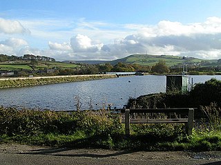
Llyn Fawr is a reservoir that occupies one of a series glacial cirques that form the northern escarpment of the South Wales Coalfield uplands, overlooking the heads of the Vale of Neath and the Cynon Valley, South Wales. It is known as the site of an important hoard of weapons and tools from the late Bronze Age and early Iron Age.

<span class="mw-page-title-main">Cantref Reservoir</span> Reservoir in Wales

Cantref Reservoir is the middle of the three reservoirs in the Taff Fawr valley in Wales. It was built by Cardiff Corporation Waterworks between 1886 and 1892, but since 1973 has been owned by Welsh Water. It is located in the Brecon Beacons National Park, mostly in the Powys unitary authority area and within the historic county boundaries of Breconshire. Part of the south west corner is in the Rhondda Cynon Taff unitary authority area.

<span class="mw-page-title-main">Toddbrook Reservoir</span> English reservoir

Toddbrook Reservoir, a feeder for the Peak Forest Canal, opened in 1838. It is sited above the town of Whaley Bridge in the Derbyshire High Peak area of England. The reservoir is a Site of Special Scientific Interest (SSSI) providing habitats for herons, ducks and other animals and fish, while rare mosses and liverworts grow on its shores, particularly short-lived species that grow on seasonally exposed mud. The reservoir is used for sailing and angling. The Peak District Boundary Walk runs around the eastern end of the reservoir. The reservoir is owned by the Canal & River Trust and, like the nearby Combs Reservoir, is a feeder reservoir for the Peak Forest Canal. The feeder runs through Whaley Bridge, and with the Combs feed enters the canal system in a pool close to the transhipment shed at the Whaley Bridge canal basin.

Coquitlam Dam is a hydraulic fill embankment dam on the Coquitlam River in the city of Coquitlam, British Columbia. Although it has no powerhouse of its own, its waters divert to Buntzen Lake, making it part of BC Hydro's electrical generation infrastructure. It is also one of the main reservoirs for the Greater Vancouver Water District. BC Hydro has released a new document in March 2018 that addresses emergency preparedness and outlines the areas effected should the dam fail as a result of an extreme earthquake event.

<span class="mw-page-title-main">Mosul Dam</span> Dam in Iraq

Mosul Dam, formerly known as Saddam Dam, is the largest dam in Iraq. It is located on the Tigris river in the western governorate of Nineveh, upstream of the city of Mosul. The dam serves to generate hydroelectricity and provide water for downstream irrigation. At full capacity, the structure holds about 11.1 cubic kilometres (2.7 cu mi) of water and provides electricity to the 1.7 million residents of Mosul.

<span class="mw-page-title-main">Pontygwaith, Rhondda</span> Human settlement in Wales

Pontygwaith is a small village located in the Rhondda Fach valley in the county borough of Rhondda Cynon Taf, Wales, in the community of Tylorstown.

<span class="mw-page-title-main">Pontsticill Reservoir</span> Reservoir in Merthyr Tydfil, Wales

Pontsticill Reservoir or Taf Fechan Reservoir is a large reservoir on the Taf Fechan lying partly in the county of Powys and partly within the county borough of Merthyr Tydfil in south Wales. It lies within the Brecon Beacons National Park and Fforest Fawr Geopark.

<span class="mw-page-title-main">Fontenelle Dam</span> Dam on the Green River in Wyoming

Fontenelle Dam was built between 1961 and 1964 on the Green River in southwestern Wyoming. The 139-foot (42 m) high zoned earthfill dam impounds the 345,360-acre-foot (0.42600 km3) Fontenelle Reservoir. The dam and reservoir are the central features of the Seedskadee Project of the U.S. Bureau of Reclamation, which manages the Fontenelle impoundment primarily as a storage reservoir for the Colorado River Storage Project. The dam suffered a significant failure in 1965, when the dam's right abutment developed a leak. Emergency releases from the dam flooded downstream properties, but repairs to the dam were successful. However, in 1983 the dam was rated "poor" under Safety Evaluation of Existing Dams (SEED) criteria, due to continuing seepage, leading to an emergency drawdown. A concrete diaphragm wall was built through the core of the dam to stop leakage.

Maerdy Colliery was a coal mine located in the South Wales village of Maerdy, in the Rhondda Valley, located in the county borough of Rhondda Cynon Taf, and within the historic county boundaries of Glamorgan, Wales. Opened in 1875, it closed in December 1990.

References

  1. Ordnance Survey 1:25,000 scale Explorer map sheet 166 Rhondda & Merthyr Tydfil/Merthyr Tudful
  2. 1 2 3 4 5 6 7 8 "40 years since Rhondda Fach nearly flooded". WalesOnline. Media Wales. 21 January 2010. Retrieved 11 March 2020.
  3. 1 2 "Wales (Lluest-Wen Reservoir)". Hansard. Archived from the original on 5 July 2009. Retrieved 11 March 2020.
  4. 1 2 3 4 5 6 7 8 Ackers, John; Pether, Rachel; Warren, Alan (September 2018). "Lluest Wen: the near failure and subsequent repair of a Pennine type dam". Dams and Reservoirs. 28 (3): 119–122. doi: 10.1680/jdare.18.00038 . S2CID   117237033 . Retrieved 11 March 2020 via Institute of Civil Engineers Virtual Library.
  5. "Britain's Ten Wettest Places". The Daily Telegraph. 16 September 2016. Retrieved 11 March 2020.
  6. 1 2 Farrell, John (15 January 1970). "To Save a Valley" . The Guardian. p. 13. Retrieved 11 March 2020 via Newspapers.com.
  7. 1 2 Fishlock, Trevor (26 January 1970). "Welsh dam emergency overcome" . The Times. p. 2. Retrieved 12 March 2020 via The Times Digital Archive.
  8. "Dams to be Inspected" . The Guardian. 16 January 1970. p. 7. Retrieved 11 March 2020 via Newspapers.com.