Gilfach Goch

Last updated

Gilfach Goch
GilfachGochSouthWales.jpg
Rhondda Cynon Taf UK location map.svg
Red pog.svg
Gilfach Goch
Location within Rhondda Cynon Taf
Population3,436 (2011) [1]
Principal area
Ceremonial county
Country Wales
Sovereign state United Kingdom
Post town Porth
Postcode district CF39
Police South Wales
Fire South Wales
Ambulance Welsh
UK Parliament
List of places
UK
Wales
Rhondda Cynon Taf
51°35′31″N3°28′23″W / 51.592°N 3.473°W / 51.592; -3.473 Coordinates: 51°35′31″N3°28′23″W / 51.592°N 3.473°W / 51.592; -3.473

Gilfach Goch is a community, electoral ward and small former coal mining village mostly in the Borough of Rhondda Cynon Taf, south Wales, near the larger community of Tonyrefail. Some areas in the North Western part of the village lie within Bridgend County Borough. It is situated in the Cwm Ogwr Fach (Small Ogmore Valley) between the Cwm Ogwr Fawr (Large Ogmore Valley) to the west and the Cwm Rhondda (Rhondda Valley) to the east.

Contents

Etymology

The translation of Gilfach Goch into English is easily understood (cil = nook or secluded area, bach = small) but several theories have been put forward as to where the name came from, especially the term coch = red. [2] Writing in 1887, Thomas Morgan, put forward the idea that the name was derived from "...a heap of red cinders, which still remains as a memento of the ironworks that stood there in times of yore". [3]

In 1903 local historian Owen Morgan theorised that the area was the location of an ancient site of importance to the local druids. During the Roman Conquest of Britain, Roman cavalry attacked the 'defenceless of Dinas', but were routed when thousands heeded the call of the Druids. Morgan concludes that coch refers to the blood shed by the defeated Roman soldiers. [4]

These theories have been queried more recently, as it has been shown that the area known as Gilfach Goch and, in particular, the site where the red cinders of the ironworks are found, was not originally named as such. [5] Prior to 1860, Gilfach Goch was an area of mountain land situated in the Ogwr Fach valley in the parish of Ystradyfodwg far north of present-day Gilfach. Ordnance survey maps have shown that the name Gilfach Goch is not only the name of the community that sprang up with the coming of coal, but the hill and a strip of land on the east bank of the Ogwr Fach. [5] This section of the Ogwr Fach valley is very narrow and lends itself to the description cil-fach, but is also home to a tributary of the River Ogwr whose bed contains iron ore. The ore reddens the appearance of the stream, which could be the origin of the name. [5]

History

Gilfach Goch developed as coal mining village during the industrialisation of the south Wales valleys in the 19th century. Three pits were sunk in the area, the Britannic, the Dinas Main and the Trane and Llewellyn. [6] Evan Evans, a self-made businessman, acquired the mineral rights to large parts of land of Gilfach Goch in the early 1860s. [6] His first mine, the first in Gilfach Goch, was the Dinas Main Colliery. [6] It reached the Rhondda No.3 seam in 1868 and was known for its high quality coal and coke. [6] The Dinas Main Colliery Company sank two shafts into the steam coal measure between 1894 and 1896, and this pit became known as the Britannic Merthyr Colliery. [6] In 1907 an explosion occurred at the Dinas Main Colliery. Seven men were killed, while others escaped through an old horse-way tunnel. [6] The Dinas Main was closed after the accident, the Trane pit closed in 1953 and the Britannic closed in 1960. [6]

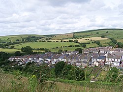
The scattered development of the village's collieries caused a similar scattered approach to the housing, the logic of their placement now lost that the mines have all since closed. [7] At the south end of the village there are a series of parallel cul-de-sac properties lined with cottage pairs, not terraces which are synonymous to the region. [7] This unusual layout was promoted by the Cardiff-based Welsh Garden Cities Ltd as their first Garden Village and was built between 1910 and 1914. [7]

In the 2001 census, of all rural areas with a population over 1,500, Gilfach Goch had the largest percentage of people in the whole of England and Wales who stated that they had no religion. [8] [9]

Buildings

The oldest building in the village is the Griffin Inn, a public house which is situated in low marshy ground at the end of a country lane.

The most notable religious building is the church of St Barnabas which began construction in 1896 and was completed in 1899. [7] A nave with a lower chancel was added in 1933. During the Second World War the church was hit by a Luftwaffe bomb; it was reconstructed in the 1950s. [7] [10]

Governance

The Gilfach Goch electoral ward is coterminous with the borders of the Gilfach Goch community [11] and elects a county councillor to Rhondda Cynon Taf County Borough Council. Since 1995 the ward has been represented by Aurfron Roberts, who has stood for the Labour Party since 1999. [12] At the May 2017 election Labour and Plaid Cymru won a councillor each. [13]

Gilfach Goch Community Council represents the community at the local level, with seven community councillors. [14]

Residents of note

Related Research Articles

<span class="mw-page-title-main">Treorchy</span> Human settlement in Wales

Treorchy is a town and community in Wales. Once a mining town, it retains such characteristics. Situated in the county borough of Rhondda Cynon Taf in the Rhondda Fawr valley. Treorchy is also one of the 16 communities of the Rhondda. It includes the villages of Cwmparc and Ynyswen.

<span class="mw-page-title-main">Ynysybwl</span> Human settlement in Wales

Ynysybwl is a village in Cwm Clydach in Wales. It is situated in the county borough of Rhondda Cynon Taf, roughly 15 miles (24 km) north-north-west of Cardiff, 4 miles (6 km) north of Pontypridd and 16 miles (26 km) south of Merthyr Tydfil, and forms part of the community of Ynysybwl and Coed-y-Cwm.

<span class="mw-page-title-main">Llwynypia</span> Human settlement in Wales

Llwynypia is a village and community in Rhondda Cynon Taf, Wales, near Tonypandy in the Rhondda Fawr Valley. Before 1850 a lightly populated rural farming area, Llwynypia experienced a population boom between 1860 and 1920 with the sinking of several coal mines after the discovery of large coal deposits throughout the Rhondda Valleys.

<span class="mw-page-title-main">Ynyshir</span> Human settlement in Wales

Ynyshir is a village and community located in the Rhondda Valley, within Rhondda Cynon Taf, South Wales. The name of the village means "long island" in Welsh and takes its name from a farm in the area, falling within the historic parishes of Ystradyfodwg and Llanwynno (Llanwonno). The community of Ynyshir lies between the small adjoining village of Wattstown and the larger town of neighbouring Porth.

<span class="mw-page-title-main">Ogmore (UK Parliament constituency)</span> Parliamentary constituency in the United Kingdom, 1918 onwards

Ogmore is a constituency created in 1918 represented in the House of Commons of the UK Parliament by Chris Elmore of the Labour Party.

<span class="mw-page-title-main">Rhondda</span> Urban area and district in South Wales

Rhondda, or the Rhondda Valley, is a former coalmining area in South Wales, historically in the county of Glamorgan. It takes its name from the River Rhondda, and embraces two valleys – the larger Rhondda Fawr valley and the smaller Rhondda Fach valley – so that the singular "Rhondda Valley" and the plural are both commonly used. The area forms part of the South Wales Valleys. From 1897 until 1996 there was a local government district of Rhondda. The former district at its abolition comprised sixteen communities. Since 1996 these sixteen communities of the Rhondda have been part of Rhondda Cynon Taf County Borough. The area of the former district is still used as the Rhondda Senedd constituency and Westminster constituency, having an estimated population in 2020 of 69,506. It is most noted for its historical coalmining industry, which peaked between 1840 and 1925. The valleys produced a strong Nonconformist movement manifest in the Baptist chapels that moulded Rhondda values in the 19th and early 20th centuries. It is also known for its male voice choirs and in sport and politics.

<span class="mw-page-title-main">Ferndale, Rhondda Cynon Taf</span> Human settlement in Wales

Ferndale is a town and community located in the Rhondda Valley in the county borough of Rhondda Cynon Taf, Wales. Neighbouring villages are Blaenllechau, Maerdy and Tylorstown. Ferndale was industrialised in the mid-19th century. The first coal mine shaft was sunk in 1857 and was the first community to be intensively industrialised in the Rhondda Valley.

<span class="mw-page-title-main">Beddau</span> Human settlement in Wales

Beddau is a large former mining village situated within the South Wales Valleys around 1.5 miles (2.4 km) from Llantrisant and 4 miles (6.4 km) from the larger town of Pontypridd in the county borough of Rhondda Cynon Taf, South Wales.

<span class="mw-page-title-main">Penrhiwceiber</span> Human settlement in Wales

Penrhiwceiber is a small Welsh village and community in the county borough of Rhondda Cynon Taf that lies south of the town Aberpennar and north of the village of Tyntetown, and is one of many villages that lies within the Cynon Valley. Prior to 1870 the area was heavy woodland, but the opening of the Penrhiwceiber Colliery in 1878 saw its rapid expansion into a thriving village.

<span class="mw-page-title-main">Tonyrefail</span> Village in South Wales

Tonyrefail is a village and community in the Rhondda Cynon Taf County Borough, Wales. It is situated at the head of the River Ely; 4 miles (6.4 km) northwest of Llantrisant, about 1.5 miles (2.4 km) from Trebanog and about 2 miles (3.2 km) from Williamstown. During the second half of the 19th century, when coal and steel became synonymous with the South Wales Valleys, Tonyrefail evolved from being a rural hamlet to an industrial village. The population at the 2001 census was 11,035.

<span class="mw-page-title-main">Clydach Vale</span> Village in Rhondda Cynon Taf, Wales

Clydach Vale is a village in the community of Cwm Clydach, northwest of Tonypandy in the county borough of Rhondda Cynon Taf, within the Rhondda Valley, Wales. It is named for its situation on the Nant Clydach, a tributary of the River Rhondda. The village is deemed part of the Tonypandy built-up area by the Office for National Statistics and comes under the Tonypandy post town.

<span class="mw-page-title-main">Trealaw</span> Human settlement in Wales

Trealaw is a long village, also a community and electoral ward in the Rhondda Valley, Rhondda Cynon Taf, Wales. It stretches over two miles from the junction of Cemetery Road and Brithweunydd Road in the east, to the junction of Ynyscynon Road and Partridge Road to the northwest.

<span class="mw-page-title-main">Ogmore (Senedd constituency)</span> Constituency of the Senedd

Ogmore is a constituency of the Senedd. It elects one Member of the Senedd by the first past the post method of election. It is one of seven constituencies in the South Wales West electoral region, which also elects four additional members, to produce a degree of proportional representation for the region as a whole.

<span class="mw-page-title-main">Rhondda Cynon Taf County Borough Council</span> Local government of Rhondda Cynon Taf, Wales

Rhondda Cynon Taf County Borough Council is the governing body for Rhondda Cynon Taf, one of the Principal Areas of Wales. The council headquarters are located in the community of Cwm Clydach on the outskirts of Tonypandy.

<span class="mw-page-title-main">Ogmore Vale</span> Human settlement in Wales

Ogmore Vale is a village in the county borough of Bridgend, Wales on the River Ogmore. The village's main source of income came from coal mining. Up until the year 1865, the Ogmore valley was a quiet, isolated, rural hill farming community of less than ten farms and a few cottages. Today, along with Nantymoel and Price Town it makes up the community of Ogmore Valley.

<span class="mw-page-title-main">Penygraig</span> Human settlement in Wales

Penygraig is a village and community in the Rhondda Valley in the county borough of Rhondda Cynon Taf, Wales. As a community Penygraig contains the neighbouring districts of Dinas, Edmondstown, Penrhiwfer and Williamstown. Penygraig is within the historic county boundaries of Glamorgan. The name Penygraig is Welsh for 'head of the rock'.

Pentre is a village, community and electoral ward near Treorchy in the Rhondda valley, falling within the county borough of Rhondda Cynon Taf, Wales. The village's name is taken from the Welsh word Pentref, which translates as homestead, though Pentre is named after a large farm that dominated the area before the coming of industrialisation. The community takes in the neighbouring village of Ton Pentre.

<span class="mw-page-title-main">Ogmore Valley</span> Human settlement in Wales

Ogmore Valley is a community in the Bridgend County Borough, Mid Glamorgan, Wales. Made up of the villages of Nantymoel, Ogmore Vale, Price Town and Wyndham, its population at the time of the 2001 census was 7,800, increasing to 7,954 at the 2011 Census. The ribbon housing of the valley follows the Ogwr Fawr tributary which rises at Craig Ogwr and joins the Ogwr Fach at Blackmill. Villages include Nantymoel, Price Town, Wyndham, Ogmore Vale, Lewistown, Pant-yr-awel and Blackmill.

Cwm Clydach is a community and electoral ward to the northwest of Tonypandy in Rhondda Cynon Taf, Wales. The community and ward covers the valley of the Nant Clydach, which includes the cojoined villages of Clydach Vale and Blaenclydach.

References

  1. "Community population 2011" . Retrieved 15 November 2015.
  2. Davies 1981, p. 184.
  3. Morgan, Thomas (1887). The Place Names of Wales. Printed for the author by H.W. Southey. p.  178.
  4. Morgan, Owen (1903). A History of Pontypridd and Rhondda Valleys. pp. 264–269.
  5. 1 2 3 Davies 1981, p. 185.
  6. 1 2 3 4 5 6 7 "Britannic Colliery". welshcoalmines.co.uk. Retrieved 4 April 2016.
  7. 1 2 3 4 5 Newman, John (1995). Glamorgan. London: Penguin Group. p. 359. ISBN   0140710566.
  8. "Table KS07 Religion" (xls). Office for National Statistics.
  9. "Census reveals best area for love". BBC News. 22 July 2004. Retrieved 15 June 2012.
  10. "Memories of Evanstown and Gilfach Goch" (PDF). Retrieved 5 April 2016.
  11. "Election maps". Ordnance Survey . Retrieved 27 October 2018.
  12. Rhondda Cyon Taff County Borough Council Election Results 1995-2012, The Election Centre. Retrieved 27 October 2018.
  13. County Borough Council Elections 2017, Rhondda Cynon Taf County Borough Council. Retrieved 27 October 2018.
  14. Councillors, Gilfach Goch Community Council. Retrieved 27 October 2018.
  15. "Details of Lot 119". Auction Catalogue. Graham Budd Auctions. 10 May 2007. Retrieved 9 November 2011.
  16. Davies, John; Jenkins, Nigel (2008). The Welsh Academy Encyclopaedia of Wales. Cardiff: University of Wales Press. p. 513. ISBN   978-0-7083-1953-6.
  17. "GRIFFITHS, WILLIAM (1898 - 1962), bookseller". Y Bywgraffiadyr Cymreig / Dictionary of Welsh Biography. 17 November 2022.
  18. "The Salon that Began in Gilfach Goch". Rhys Davies Trust. 4 July 2019.

Bibliography