Maesteg is a town and community in Bridgend County Borough, Wales. Maesteg lies at the northernmost end of the Llynfi Valley, close to the border with Neath Port Talbot. In 2011, Maesteg had a population of 20,612. The English translation of Maesteg is 'fair field'.
The Rhymney Railway (RR) was a railway company in South Wales, founded to transport minerals and materials to and from collieries and ironworks in the Rhymney Valley of South Wales, and to docks in Cardiff. It opened a main line in 1858, and a limited passenger service was operated in addition.

Tondu is a village in Bridgend County Borough, Wales, located about 3 miles (4.8 km) north of the town of Bridgend, in the community of Ynysawdre.

The Maesteg Line is a commuter rail line in South Wales from Bridgend to Maesteg. Services usually operate from Maesteg to Cheltenham Spa and Cardiff Central via the South Wales Main Line and Gloucester to Newport Line.

Pyle railway station is a minor station in Pyle in Bridgend county borough, south Wales. The station is located at street level at Beach Road in Pyle, 196 miles 40 chains (316.2 km) from the zero point at London Paddington, measured via Stroud.
The Garw Valley Railway is the trading name of the Bridgend Valleys Railway Company Limited. It operates a short section of 4 ft 8+1⁄2 instandard gauge railway located in South Wales, which is being recreated as a heritage railway. Formerly part of the Llynvi and Ogmore Railway (L&OR) and built by the Great Western Railway (GWR), the line was used for freight and passenger services, with most of the track still in place between Brynmenyn and Pontycymer. The project currently has a train shed at Pontycymer, and hopes to initially offer brake van rides between Pontycymer and Pant-y-Gog, a distance of 0.5 miles (0.8 km).

Treherbert railway station serves the village of Treherbert in Rhondda Cynon Taf, Wales. It is the northern terminus of the Rhondda Line.
In 1861 the Llynvi Valley Railway was opened in Glamorganshire, Wales, to convey mineral products to the Bristol Channel at Porthcawl. It adopted an earlier tramroad, the Duffryn Llynvi and Porthcawl Railway. The Llynvi and Ogmore Railway was opened in 1865, and the two companies amalgamated to form the Llynvi and Ogmore Railway in 1866. At first Porthcawl harbour was an important destination for onward transport, but this soon declined.

Sarn is a village in Bridgend County Borough, Wales, about three miles north of Bridgend and which lies just east of the confluence of the Ogmore and Llynfi rivers. It is located to the east of Aberkenfig, south of Brynmenyn, and south-east of Tondu. It is around 15 minutes' walk from the M4 and the McArthurGlen Group Bridgend Designer Outlet.

Ogmore Vale is a village in the county borough of Bridgend, Wales on the River Ogmore. The village's main source of income came from coal mining. Up until the year 1865, the Ogmore valley was a quiet, isolated, rural hill farming community of less than ten farms and a few cottages. Today, along with Nantymoel and Price Town it makes up the community of Ogmore Valley.
The Vale of Glamorgan Railway Company was built to provide access to Barry Docks from collieries in the Llynfi, Garw and Ogmore valleys. Proposed by the coalowners but underwritten by the wealthy Barry Railway Company, it opened in 1897 from near Bridgend to Barry, in Wales.
The Rhondda and Swansea Bay Railway was a Welsh railway company formed to connect the upper end of the Rhondda Fawr with Swansea, with the chief objective of transporting coal and other minerals to Swansea docks. It was incorporated in 1882, but at first the connection to Swansea from Briton Ferry was refused.
John Brogden and Sons was a firm of Railway Contractors, Iron and Coal Miners and Iron Smelters operating, initially as a general contractor, from roughly 1828 until its bankruptcy in 1880.
The Port Talbot Railway and Docks Company (PTR&D) was formed in 1894 to secure the means of bringing minerals, chiefly coal, to the harbour in South Wales. It took over the docks at Port Talbot that had been operated by the Port Talbot Company. It opened its main line in 1897 and reached a connection with the Great Western Railway Garw Valley line the following year. A branch line to collieries near Tonmawr also opened in 1898. The lines were extremely steeply graded and operation was difficult and expensive, but the company was successful. Passenger operation on the main line started in 1898, but this was never a principal part of the business. For some time most of the passenger train service was operated by a railmotor that was the largest ever to work in the United Kingdom. Also in 1898 the Ogmore Valleys Extension (OVE) line, a part of the PTR&D, was opened. It had been projected as a defensive measure against competitive incursion, and it led from Margam Junction towards Tondu.
The Llantrisant and Taff Vale Junction Railway was a railway company that constructed a standard gauge line in South Wales, connecting Llantrisant and the Taff Vale Railway near Treforest. It ran through thinly populated country, and linked to a number of iron mines, collieries and other mineral sites. It opened in stages in 1863 and 1864. In 1865 through passenger trains from the Cowbridge Railway ran over the line, to Pontypridd, although for some time there were no passenger stations on its own network. At the Llantrisant end, it was reliant on broad gauge railway companies which were not always friendly to it. The company leased its line to the Taff Vale Railway in 1870.
Rail transport in Cardiff has developed to provide connections to many other major cities in the United Kingdom, and to provide an urban rail network for the city and its commuter towns in southeast Wales. Today, there are three train operating companies in Cardiff: Great Western Railway, CrossCountry and Transport for Wales.

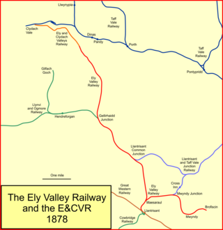
The Ely Valley Railway (EVR) was a broad gauge railway company in South Wales, which opened a mineral line between Llantrisant station on the South Wales Railway main line and pits at Mwyndy and Penrhiwfer in 1860.

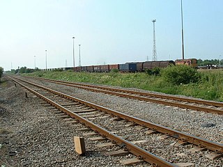
Margam Knuckle Yard is a railway yard in Margam, South Wales, on the South Wales Main Line, operated by DB Schenker Rail (UK). The yard is the major freight yard of the region, handling all of the rail freight movements from Port Talbot Steelworks, and most of the railfreight traffic around South Wales.

Porthcawl railway station served the seaside resort of Porthcawl in South Wales. It closed in 1963.


