
The A38, parts of which are known as Devon Expressway, Bristol Road and Gloucester Road, is a major A-class trunk road in England.

The M5 is a motorway in England linking the Midlands with the South West. It runs from junction 8 of the M6 at West Bromwich near Birmingham to Exeter in Devon. Heading south-west, the M5 runs east of West Bromwich and west of Birmingham through Sandwell Valley. It continues past Bromsgrove, Droitwich Spa, Worcester, Tewkesbury, Cheltenham, Gloucester, Bristol, Portishead, Clevedon, Weston-super-Mare, Bridgwater, Taunton, Tiverton, Cullompton terminating at junction 31 for Exeter.

The A20 is a major road in south-east England, carrying traffic from London to Dover in Kent. Parts of the route date back to turnpikes established in the early part of the 18th century. The line of the road throughout Kent runs closely in parallel with the M20 motorway.

Stourbridge is a market town in the Metropolitan Borough of Dudley in the West Midlands, England. Situated on the River Stour, the town lies around 10 miles west of Birmingham. Historically in Worcestershire, it was the centre of British glass making during the Industrial Revolution. The 2011 UK census recorded the town's population as 63,298.
The A19 is a major road in England running approximately parallel to and east of the A1 road. Although the two roads meet at the northern end of the A19, the two roads originally met at the southern end of the A19 in Doncaster, but the old route of the A1 was changed to the A638. From Sunderland northwards, the route was formerly the A108. In the past the route was known as the East of Snaith-York-Thirsk-Stockton-on-Tees-Sunderland Trunk Road. Most traffic joins the A19, heading for Teesside, from the A168 at Dishforth Interchange.

Kingswinford is a town of the Metropolitan Borough of Dudley in the English West Midlands, situated 5 miles (8 km) west-southwest of central Dudley. In 2011 the area had a population of 25,191, down from 25,808 at the 2001 Census.

The A458 is a route on the UK highway network that runs from Mallwyd, near Machynlleth, in Wales, merging with the A456 Hagley Road and the Quinton Expressway on the outskirts of Birmingham, in England. On the way it passes through Welshpool, Shrewsbury, Much Wenlock, Bridgnorth, Stourbridge and Halesowen

Known as the Hagley Road in Birmingham, the A456 is a main road in England running between Central Birmingham and Woofferton, Shropshire, south of Ludlow. Some sections of the route, for example Edgbaston near Bearwood, are also the route of the Elan Aqueduct which carries Birmingham's water supply from the Elan Valley.

The A449 is a major road in the United Kingdom. It runs north from junction 24 of the A48 road at Newport in South Wales to Stafford in Staffordshire.

The A4150 Wolverhampton Inner Ring Road is a ring road that encircles the city centre of Wolverhampton in the West Midlands, England. The circumference of the road is around 2.1 miles (3.4 km). Technically, the route is listed as an "Inner Ring Road", although only a tiny section of the "Outer Ring Road" was ever constructed with only one of the two designed carriageways built. A second carriageway was built in 2017 along a short stretch between Patshull Avenue and Stafford Road. The section of outer ring road is called Wobaston Road and locally classified by Wolverhampton City Council as U119.
Wordsley is a suburban village near Stourbridge in the West Midlands, England. It is part of the Metropolitan Borough of Dudley and is north of the River Stour. Wordsley is part of the Kingswinford and South Staffordshire Parliamentary constituency as of 2024. It is bordered by open Staffordshire countryside to the west, Kingswinford to the north, Brierley Hill to the east and Stourbridge to the south.

The A165 is a road that links Scarborough and Kingston upon Hull, both in Yorkshire, England. The road is designated as a Primary Route from its junction with the A64 in Scarborough to its southern terminus in Hull.

The A18 is a road in England that links Doncaster in South Yorkshire with Ludborough in Lincolnshire, via Scunthorpe and Grimsby. Much of its route has been superseded by the M180 motorway.

Hagley is a village and civil parish in Worcestershire, England. It is on the boundary of the West Midlands and Worcestershire counties between the Metropolitan Borough of Dudley and Kidderminster. Its estimated population was 7,162 in 2019.

Oldswinford or Old Swinford is an area south of the centre of Stourbridge, in the Dudley district, in the county of the West Midlands, England.

The A146 is an A road that connects Norwich in Norfolk and Lowestoft in Suffolk, two of East Anglia's largest population centres. It is around 27 miles (43 km) in length and has primary classification along its entire route. It is mainly single carriageway throughout its route, with the exception of a section of dual carriageway on the southern edge of Norwich.

The A329 is an east–west road in Southern England that runs from Wentworth in Surrey to Thame in Oxfordshire.

The A459 is a main road in the West Midlands of England, which runs from Halesowen to Wolverhampton City Centre. Is also a primary route connecting Wolverhampton and Dudley.
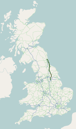
The A617 road runs through the northern East Midlands, England, between Newark-on-Trent and Chesterfield.

The A448 is a main road in England running between Studley in Warwickshire and Kidderminster in Worcestershire.

