
The A40 is a trunk road which runs between London and Goodwick (Fishguard), Wales, and officially called The London to Fishguard Trunk Road (A40) in all legal documents and Acts. Much of its length within England has been superseded by motorways, such as the M40, and has lost its trunk road status, though it retains it west of Gloucester, including its length within Wales. It is approximately 260 miles (420 km) long. The eastern section from Denham, Buckinghamshire to Wheatley, Oxfordshire is better served by the M40 and its former function of linking London with Cheltenham and Gloucester has been taken by the M4, A419 and A417 via Swindon.

Merthyr Tydfil is the main town in Merthyr Tydfil County Borough, Wales, administered by Merthyr Tydfil County Borough Council. It is about 23 miles (37 km) north of Cardiff. Often called just Merthyr, it is said to be named after Tydfil, daughter of King Brychan of Brycheiniog, who according to legend was slain at Merthyr by pagans about 480 CE. Merthyr generally means "martyr" in modern Welsh, but here closer to the Latin martyrium: a place of worship built over a martyr's relics. Similar place names in south Wales are Merthyr Cynog, Merthyr Dyfan and Merthyr Mawr.
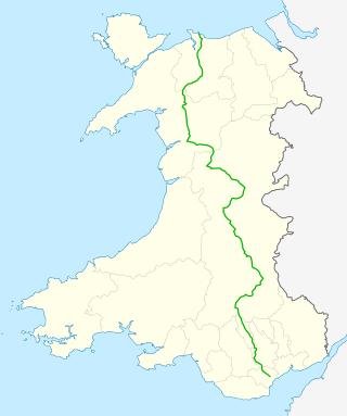
The A470 is a trunk road in Wales. It is the country's longest road at 186 miles (299 km) and links the capital Cardiff on the south coast to Llandudno on the north coast. While previously one had to navigate the narrow roads of Llanidloes and Dolgellau, both these market towns are now bypassed due to extensive road modernisation. The 26 miles (42 km) from Cardiff Bay to Merthyr Tydfil are mainly dual carriageway, but most of the route from north of Merthyr to Llandudno is single carriageway.

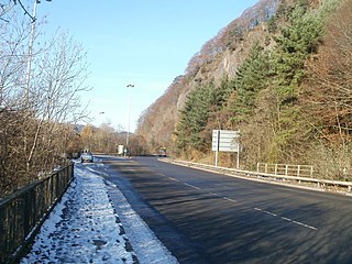
The A465 is a trunk road that runs from Bromyard in Herefordshire, England to Llandarcy near Swansea in South Wales. The western half is known officially as the Neath to Abergavenny Trunk Road, but the section from Abergavenny to the Vale of Neath is more commonly referred to as the Heads of the Valleys Road because it links the northern heads of the South Wales Valleys. Approximately following the southern boundary of the Brecon Beacons National Park, the Ordnance Survey Pathfinder guide describes it as the unofficial border between rural and industrial South Wales. The A465 provides an alternative route between England and the counties in South West Wales and to the ferries to Ireland.

The Taff Trail is a popular walking and cycle path that runs for 55 miles (89 km) between Cardiff Bay and Brecon in Wales. It is so named because it follows the course of the River Taff. Along much of its length, it follows the National Cycle Network Route 8 that continues to Holyhead, and is substantially off-road.

The River Taff is a river in Wales. It rises as two rivers in the Brecon Beacons; the Taf Fechan and the Taf Fawr before becoming one just north of Merthyr Tydfil. Its confluence with the River Severn estuary is in Cardiff.
The Brecon and Merthyr Tydfil Junction Railway (B&MR) was a railway company in Wales. It was originally intended to link the towns in its name. Finding its access to Merthyr difficult at first, it acquired the Rumney Railway, an old plateway, and this gave it access to Newport docks. This changed its emphasis from rural line to mineral artery.

The South Wales Valleys are a group of industrialised peri-urban valleys in South Wales. Most of the valleys run north–south, roughly parallel to each other. Commonly referred to as "The Valleys", they stretch from Carmarthenshire in the west to Monmouthshire in the east; to the edge of the pastoral country of the Vale of Glamorgan and the coastal plain near the cities of Swansea, Cardiff, and Newport.

Transport in Wales is heavily influenced by the country's geography. Wales is predominantly hilly or mountainous, and the main settlements lie on the coasts of north and south Wales, while mid Wales and west Wales are lightly populated. The main transport corridors are east–west routes, many continuing eastwards into England.
Nelson is a village and community in the County Borough of Caerphilly, Wales. It sits five miles north of Caerphilly and ten miles north of Cardiff, at the lower end of the Taff Bargoed Valley, and lies adjacent to Treharris, Trelewis and Quakers Yard.

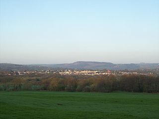
Fochriw is a village located in Caerphilly County Borough, Wales, United Kingdom. It was well known for its neighbouring collieries, which employed nearly the entire local population in the early 20th century. It lies within the historic county boundaries of Glamorgan. The village appears as the backdrop on the BBC Wales sitcom High Hopes credits. The villages population was recorded as 1,250 in 2011.

The A4059 road is a single-carriageway north–south road that runs between the A470 at Brecon Beacons National Park and the A470 at Abercynon.
The A4054 is an A Road connecting Llandaff, Cardiff with Merthyr Tydfil in Wales and mostly follows the former route of the A470.

Cefn-coed-y-cymmer is a small community on the northwestern edge of Merthyr Tydfil County Borough in Wales. It is situated in the neck of land between the rivers Taf Fawr and Taf Fechan at their confluence. The village lies within the community of Vaynor. Immediately to the north of the village is the hill of Cefn Cil Sanws on the southern slopes of which is Merthyr Tydfil Golf Club. The village is bounded both to the north and the west by the Brecon Beacons National Park.

Merthyr Tydfil County Borough is a county borough in the south-east of Wales. In mid 2018, it had an estimated population of 60,183 making it the smallest local authority in Wales by both population and land area. It is located in the historic county of Glamorgan and takes its name from the town with the same name. The county borough consists of the northern part of the Taff Valley and the smaller neighbouring Taff Bargoed Valley. It borders the counties of Rhondda Cynon Taf to the west, Caerphilly County Borough to the east, and Powys to the north.

Trunk roads in Wales were created in the Trunk Roads Act of 1936 when the UK Ministry of Transport took direct control over 30 of the principal roads in Great Britain from English, Welsh and Scottish local authorities. The number of trunk roads was increased from 30 to 101 in the Trunk Roads Act of 1946. These roads formed what the Act called "the national system of routes for through traffic". Since Welsh devolution the trunk road system in Wales has been managed by the South Wales Trunk Road Agent and the North and Mid Wales Trunk Road Agent on behalf of the Welsh Government. As of April 2019, out of a total of 34,850 miles (56,090 km) of roads in Wales, 1,576 miles (2,536 km) are trunk roads.

Dowlais Top railway station served the village of Dowlais, Glamorgan, Wales, from 1867 to 1962 on the Brecon and Merthyr Tydfil Junction Railway.
Groesfaen Colliery Platform railway station served the workers at Groesfaen Colliery near the town of Bargoed, Caerphilly, Wales on the Brecon and Merthyr Tydfil Junction Railway. The site of the platform does not appear on OS maps and the station was only for workers at the nearby colliery. Nothing remains of the platform or colliery and the station site has since been reused by the A469.

