Snowdonia, or Eryri, is a mountainous region and national park in North Wales. It contains all 15 mountains in Wales over 3000 feet high, including the country's highest, Snowdon, which is 1,085 metres (3,560 ft) tall. These peaks are all part of the Snowdon, Glyderau, and Carneddau ranges in the north of the region. The shorter Moelwynion and Moel Hebog ranges lie immediately to the south.
Local government in Wales is primarily undertaken by the twenty-two principal councils. The councils are unitary authorities, meaning they are responsible for providing local government services within their principal area, including education, social work, environmental protection, and most highway maintenance. The principal areas are divided into communities, most of which have an elected community council. The services provided by community councils vary, but they will typically maintain public spaces and facilities. Local councils in Wales are elected; the most recent local elections in Wales took place in 2022, and the next are due to take place in 2027.

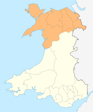
North Wales is a region of Wales, encompassing its northernmost areas. It borders mid Wales to the south, England to the east, and the Irish Sea to the north and west. The area is highly mountainous and rural, with Snowdonia National Park and the Clwydian Range and Dee Valley, known for its mountains, waterfalls and trails, wholly within the region. Its population is concentrated in the north-east and northern coastal areas, with significant Welsh-speaking populations in its western and rural areas. North Wales is imprecisely defined, lacking any exact definition or administrative structure. It is commonly defined administratively as its six most northern principal areas, but other definitions exist, with Montgomeryshire historically considered to be part of the region.

Capital Cymru is a local Welsh-language radio station owned and operated by Global. The station broadcasts to Gwynedd and Anglesey from studios in Gwersyllt, Wrexham via the Arfon transmitting station.
National Highways (NH), formerly the Highways Agency and later Highways England, is a government-owned company charged with operating, maintaining and improving motorways and major A roads in England. It also sets highways standards used by all four UK administrations, through the Design Manual for Roads and Bridges. Within England, it operates information services through the provision of on-road signage and its Traffic England website, provides traffic officers to deal with incidents on its network, and manages the delivery of improvement schemes to the network.

Transport in Wales is heavily influenced by the country's geography. Wales is predominantly hilly or mountainous, and the main settlements lie on the coasts of north and south Wales, while mid Wales and west Wales are lightly populated. The main transport corridors are east–west routes, many continuing eastwards into England.

Gwynedd Council, which calls itself by its Welsh name Cyngor Gwynedd, is the governing body for the county of Gwynedd, one of the principal areas of Wales. The council administrates internally using the Welsh language.
The subdivisions of Wales constitute a hierarchy of administrative divisions and non-administrative ceremonial areas.

North East Wales is an area or region of Wales, commonly defined as a grouping of the principal areas of Denbighshire, Flintshire, and Wrexham County Borough in the north-east of the country. These principal areas comprise most of the former administrative county of Clwyd. It is bordered by Conwy, and Gwynedd, in North West Wales to the west, Powys, in Mid Wales to the south, the English counties of Cheshire, and Shropshire to the east, and the Irish Sea, and Dee estuary to the north. It is the more urban, densely populated, and industrial part of the north Wales geographic region, centred on the city of Wrexham and the towns of Rhyl and Prestatyn, and the conurbation of Deeside. The region's close links with North West England in general and Merseyside in particular are crucial to the region's economy. The Clwydian Range and Dee Valley Area of Outstanding Natural Beauty is located in the region. Other attractions include historical buildings such as Chirk Castle, and Erddig in Wrexham, valley towns such as Corwen and Llangollen, and the Pontcysyllte Aqueduct and Canal World Heritage Site.

North West Wales is an area or region of Wales, commonly defined as a grouping of the principal areas of Conwy County Borough, Gwynedd and the Isle of Anglesey in the north-west of the country. These principal areas make up the entire preserved county of Gwynedd, and parts of Clwyd. It is bordered by Denbighshire, in North East Wales to the east, Powys, and Ceredigion in Mid Wales to the south, and the Irish sea to the north and west. It is the more mountainous, rural, and sparsely populated part of the north Wales geographic region.

Trunk roads in Wales were created in the Trunk Roads Act of 1936 when the UK Ministry of Transport took direct control over 30 of the principal roads in Great Britain from English, Welsh and Scottish local authorities. The number of trunk roads was increased from 30 to 101 in the Trunk Roads Act of 1946. These roads formed what the Act called "the national system of routes for through traffic". Since Welsh devolution the trunk road system in Wales has been managed by the South Wales Trunk Road Agent and the North and Mid Wales Trunk Road Agent on behalf of the Welsh Government. As of April 2019, out of a total of 34,850 miles (56,090 km) of roads in Wales, 1,576 miles (2,536 km) are trunk roads.

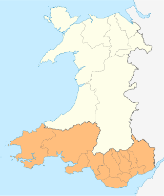
The South Wales Trunk Road Agent is one of the two trunk road agents in Wales. It is responsible for managing motorways and trunk roads in South Wales on behalf of the Welsh Government. Established on 1 April 2006 as the South Wales Trunk Road Agency, and renamed to its current name on 1 April 2012. The agent manages the motorways and trunk roads in the fourteen principal areas of the south of Wales, from the Severn Bridge in the east to Milford Haven in the west. The remainder of Wales is managed by the North and Mid Wales Trunk Road Agent.

Welsh Government traffic officers are civilian staff employed by the trunk road agents on behalf of the Welsh Government as a means to ease traffic congestion on major trunk roads in Wales. Their role and powers are similar to their English counterparts working for National Highways, the National Highways traffic officers.

The North and Mid Wales Trunk Road Agent is one of the two trunk road agents in Wales. It is responsible for managing trunk roads in North and Mid Wales on behalf of the Welsh Government. A merger of two trunk road agencies, established separately on 1 April 2006, the North Wales Trunk Road Agency and Mid Wales Trunk Road Agency, the two bodies were merged and renamed to its current name on 1 April 2012. The agent manages trunk roads in eight principal areas of the north and mid regions of Wales: the respective principal councils of Anglesey, Ceredigion, Conwy, Denbighshire, Flintshire, Gwynedd, Powys, and Wrexham. The remainder of Wales is managed by the South Wales Trunk Road Agent.

Wales has traditionally been divided into a number of ambiguous and ill-defined areas described as regions, reflecting historical, geographical, administrative, cultural and electoral boundaries within the country. Presently, the most common form of division of Wales into "regions" has been using cardinal and intercardinal references: north or south-west for example. None of the variously described "regions" have official status or defined boundaries; neither is there a fixed number of regions. Various organisations use different regions and combinations of regions for their individual purposes. This includes devolved institutions, such as Visit Wales, Natural Resources Wales, and the Welsh Government itself, using different sets of Wales' regions. Wales is most commonly sub-divided into between two and four regions, with a North–South divide, and North, Mid, South East and South West division being common. This article lists the various terms applied to be the "regions of Wales" and the regions used by various organisations.

The North Wales Corporate Joint Committee is the Corporate Joint Committee for North Wales that was established in April 2021 by statutory instruments made under the Local Government and Elections (Wales) Act 2021. It is an indirectly elected body made up of leaders of principal councils and national park authorities in the region.

The South East Wales Corporate Joint Committee is the Corporate Joint Committee for South East Wales that was established in April 2021 by statutory instruments made under the Local Government and Elections (Wales) Act 2021. It is an indirectly elected body made up of leaders of principal councils and national park authorities in the region.


