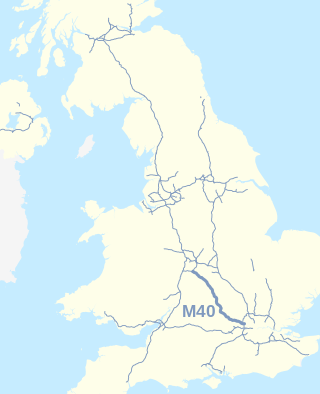
The M40 motorway links London, Oxford, and Birmingham in England, a distance of approximately 89 miles (143 km).

The A38, parts of which are known as Devon Expressway, Bristol Road and Gloucester Road, is a major A-class trunk road in England.

The M5 is a motorway in England linking the Midlands with the South West. It runs from junction 8 of the M6 at West Bromwich near Birmingham to Exeter in Devon. Heading south-west, the M5 runs east of West Bromwich and west of Birmingham through Sandwell Valley. It continues past Bromsgrove, Droitwich Spa, Worcester, Tewkesbury, Cheltenham, Gloucester, Bristol, Portishead, Clevedon, Weston-super-Mare, Bridgwater, Taunton, Tiverton, Cullompton terminating at junction 31 for Exeter. Congestion on the section south of the M4 is common during the summer holidays, on Friday afternoons and bank holidays.

The M42 motorway runs north east from Bromsgrove in Worcestershire to just south west of Ashby-de-la-Zouch in Leicestershire, passing Redditch, Solihull, the National Exhibition Centre (NEC) and Tamworth on the way, serving the east of the Birmingham metropolitan area. The section between the M40 and junction 4 of the M6 forms – though unsigned as such – a part of Euroroute E05. Northwards beyond junction 11, the route is continued as the A42; the junctions on this section, 12–14, are numbered like a continuation of the motorway, but the road has non-motorway status from here.
The A77 road is a major road in Scotland. It runs in a southwesterly direction from the city of Glasgow, past the towns of Giffnock, Newton Mearns, Kilmarnock, Prestwick, Ayr, Girvan and Stranraer to the village of Portpatrick on the Irish Sea. It passes through the council areas of Glasgow City, East Renfrewshire, East Ayrshire, South Ayrshire and Dumfries and Galloway.

The A46 is a major A road in England. It starts east of Bath, Somerset and ends in Cleethorpes, Lincolnshire, but it does not form a continuous route. Large portions of the old road have been lost, bypassed, or replaced by motorway development. Between Leicester and Lincoln the road follows the course of the Roman Fosse Way, but between Bath and Leicester, two cities also linked by the Fosse Way, it follows a more westerly course.

Redditch is a town and borough in Worcestershire, England. It is located south of Birmingham, east of Bromsgrove, northwest of Alcester and northeast of Worcester. The borough had a population of 87,037 in 2021. In the 19th century, it became a centre for the needle and fishing tackle industry.
The A45 is a major road in England. It runs east from Birmingham past the National Exhibition Centre and the M42, then bypasses Coventry and Rugby, where it briefly merges with the M45 until it continues to Daventry. It then heads to Northampton and Wellingborough before running north of Rushden and Higham Ferrers and terminating at its junction with the A14 in Thrapston.
The A590 is a trunk road in southern Cumbria, in the north-west of England. It runs north-east to south-west from M6 junction 36, through the towns of Ulverston and Barrow-in-Furness to terminate at Biggar Bank on Walney Island. The road is a mixture of dual carriageway and single carriageway, with the section east of Low Newton, Cumbria to the M6 being mainly dual. Further dual sections are south of Newby Bridge, south of Greenodd and south of Ulverston. The road is the main route for tourists entering the southern Lake District. It has often humorously been described as "the longest cul-de-sac in the world".

The A500 is a major primary A road in Staffordshire and Cheshire, England. It is dual carriageway for most of its length and connects Nantwich, junctions 16 and 15 of the M6 motorway with the city of Stoke-on-Trent. It is 19 miles (31 km) long.

Alvechurch is a large village and civil parish in the Bromsgrove district in northeast Worcestershire, England, in the valley of the River Arrow. The Lickey Hills Country Park is 2.5 miles (4 km) to the northwest. It is 11 miles south of Birmingham, 5 mi (8 km) north of Redditch and 6 mi (10 km) east of Bromsgrove. At the 2001 census, the population was 5,316.

Hopwood Park services is a motorway service station in Bromsgrove, Worcestershire, England situated off Junction 2 of the M42 motorway on the A441 road to Redditch south of Birmingham. It opened in August 1999. Services include a Shell Petrol Station, Waitrose, Starbucks Coffee, WHSmith, and KFC. Electric Vehicle charging is provided by Gridserve and Tesla.

Known as the Hagley Road in Birmingham, the A456 is a main road in England running between Central Birmingham and Woofferton, Shropshire, south of Ludlow. Some sections of the route, for example Edgbaston near Bearwood, are also the route of the Elan Aqueduct which carries Birmingham's water supply from the Elan Valley.
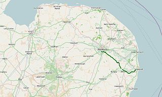
The A146 is an A road that connects Norwich in Norfolk and Lowestoft in Suffolk, two of East Anglia's largest population centres. It is around 27 miles (43 km) in length and has primary classification along its entire route. It is mainly single carriageway throughout its route, with the exception of a section of dual carriageway on the southern edge of Norwich.

The A491 is an A road in Zone 4 of the Great Britain numbering scheme.

The A6003 links Kettering and Corby in Northamptonshire, with Oakham in Rutland, via Leicestershire. The road forms the principal link between Rutland and Northamptonshire.

The A448 is a main road in England running between Studley in Warwickshire and Kidderminster in Worcestershire.
The Maypole, Birmingham is a location on the A435 road on the southern edge of Birmingham England, between Druids Heath and Highter's Heath and bordering the Bromsgrove district of Worcestershire. It has a population of 2.260 according to the 2011 Census.

The A42 is a major trunk road in the East Midlands region of the United Kingdom. It links junction 23A of the M1 motorway to junction 11 of the M42 motorway. The A42 is in effect a continuation of the M42, and its junctions are numbered accordingly.
The B4088 road is a road that runs from the crossroads with the A422 and A441 west of Alcester, Warwickshire to the A44 north of Evesham, Worcestershire, England. The road, starts at Twyford, Worcestershire and runs through the villages of Norton and Harvington, before passing into Warwickshire, Iron Cross and then Dunnington. It then turns left at the crossroads, passes through Weethley, passes back into Worcestershire and then becomes the A441 where it terminates just south of Cookhill. The road was previously the A435 between Twyford and Dunnington, where it turned left and became the A441. The road is not to be confused with the previous B4088 near Charlecote. Since it was built in 1995 the A46 dual carriageway between Evesham and Alcester now largely supersedes this road.


