Cookhill | |
---|---|
Location within Worcestershire | |
OS grid reference | SP053588 |
Civil parish |
|
District | |
Shire county | |
Region | |
Country | England |
Sovereign state | United Kingdom |
Post town | ALCESTER |
Postcode district | B49 |
Police | West Mercia |
Fire | Hereford and Worcester |
Ambulance | West Midlands |
UK Parliament | |
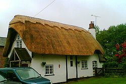
Cookhill is a village and civil parish in Worcestershire, England, on the county border near Alcester. It is close to a former Cistercian priory of the same name.
In the Domesday Book; Cookhill is mentioned as being in the Hundred of Ash in the County of Worcestershire. The total population was of five households - 2 smallholders, 2 slaves and 1 burgess.
Cookhill has been represented since 4th July 2024 by Chris Bloore of the Labour Party as part of the Redditch County Constituency, and is part of the South Redditch ward of Worcestershire County Council represented by Conservative Cllr. Anthony Hopkins. Representatives on Wychavon District Council are Cllr's Audrey Steel and David Wilkinson.
Within the village the major roads are; Salt Way, Brandheath Lane, Wood Lane, Church Lane (leading onto Cladswell Lane, Mearse Lane and Dogbut Lane), Chamberlain Lane, Oaktree Lane and Chapel Lane, all running off the A441 main Evesham Road. The A441 used to continue beyond the junction with the A422 towards Evesham but this has been downgraded to the B4088. The village is served by bus service 149 Worcester–Redditch operated by Diamond. This previously continued to Birmingham as service 150.
Worcestershire is a ceremonial county in the West Midlands of England. It is bordered by Shropshire, Staffordshire, and the West Midlands county to the north, Warwickshire to the east, Gloucestershire to the south, and Herefordshire to the west. The city of Worcester is the largest settlement and the county town.
Redditch is a town and non-metropolitan district with borough status in Worcestershire, England. It is located south of Birmingham, east of Bromsgrove, northwest of Alcester and northeast of Worcester. In 2021 the town had a population of 81,637 and the district had a population of 87,037. In the 19th century, it became a centre for the needle and fishing tackle industry.
Wychavon is a local government district in Worcestershire, England. The largest towns are Evesham and Droitwich Spa; the council is based in the town of Pershore. The district also includes numerous villages and surrounding rural areas, and includes part of the Cotswolds, a designated Area of Outstanding Natural Beauty. The district's name references the Saxon Kingdom of Hwicce and the River Avon. The population in 2022 was 134,536.
Kings Norton, alternatively King's Norton, is an area of Birmingham, in the county of the West Midlands, England. Historically in Worcestershire, it was also a Birmingham City Council ward within the Government of Birmingham. The district lies 6.5 miles south-southwest of Birmingham city centre and is within 1.5 miles of the north Worcestershire border. Kings Norton has been split into two wards, Kings Norton North and Kings Norton South.
Wythall is a large village and civil parish in the Bromsgrove District, in the northeastern corner of the county of Worcestershire, England. Wythall parish borders Solihull and Birmingham, and had a population of 12,269 in the UK census of 2021.
Studley is a large village and civil parish in the Stratford-on-Avon district of Warwickshire, England. Situated on the western edge of Warwickshire near the border with Worcestershire, it is 3.5 miles (6 km) southeast of Redditch and 13 miles (21 km) northwest of Stratford-upon-Avon. The Roman road of Ryknild Street, now the A435, passes through the village on its eastern edge, parallel to the River Arrow. The name derives from the Old English leah, being a meadow or pasture, where horses, stod, are kept.
Alvechurch is a large village and civil parish in the Bromsgrove district in northeast Worcestershire, England, in the valley of the River Arrow. The Lickey Hills Country Park is 2.5 miles (4 km) to the northwest. It is 11 miles south of Birmingham, 5 mi (8 km) north of Redditch and 6 mi (10 km) east of Bromsgrove. At the 2001 census, the population was 5,316.
Cotteridge is an area of Birmingham, England, and part of the Bournville ward. It is about 4 miles (6.4 km) miles south of Birmingham city centre. It has a shopping centre with a mixture of local shops, eateries and national brands.
A441 is an A-road in England which runs from central Birmingham to Cookhill, Worcestershire.
Feckenham is a village and civil parish in the Redditch district in Worcestershire, England. It lies some 4 miles (6 km) south-west of the town of Redditch and some 11 miles (18 km) east of the city of Worcester. It had a population of 670 in the 2001 census and its immediate area is the location of notable royal manors that cover over 1,000 years of English history documented in many royal charters and Acts of Parliament. At its greatest, the historic Forest of Feckenham stretched to the River Avon in the south and to Worcester in the west. In 1389 Geoffrey Chaucer was as Clerk of Works and Keeper of the Lodge.
Sambourne, formerly spelled Sambourn, is a village and civil parish 1.5 miles (2.4 km) north-west of Coughton, 4.5 miles (7.2 km) south of Redditch, 12 miles (19 km) north-west of Stratford-upon-Avon and 20 miles (32 km) west of Warwick in the county of Warwickshire, England. It is situated on sloping ground rising westwards to about 500 feet near the ancient Ridge Way, and forms part of the county boundary with Worcestershire. The village itself is centred round a small triangular green at the junction of four roads and contains several timber-framed buildings of 17th century date. By a designation of 22 July 1991 much of the central area became a conservation area.
Astwood Bank is a district within Redditch. Astwood Bank is near the Warwickshire - Worcestershire border, near villages such as Studley, Sambourne, Callow Hill, Feckenham, and Cookhill.
Callow Hill is an area of Redditch, in Worcestershire, England. Other villages nearby include Astwood Bank, Feckenham, Cookhill, and Webheath.
Harvington is a village near Evesham in Worcestershire, England. Bounded by the River Avon to the south and the Lench Hills to the north, three miles northeast of Evesham and now on the Worcestershire/Warwickshire border. The village today is an amalgamation of two smaller villages, Harvington and Harvington Cross, and has a population of around 1,750.
Hinton on the Green is a village and civil parish in the Wychavon district of Worcestershire in England. It is situated at the foot of Bredon Hill, about two miles south of Evesham.
Sidney Harold Meteyard RBSA was an English art teacher, painter and stained-glass designer. A member of the Birmingham Group, he worked in a late Pre-Raphaelite style heavily influenced by Edward Burne-Jones and the Arts and Crafts Movement.
Redditch is a town and local government district in Worcestershire, England. The town is divided into separate districts. All street-name signs in Redditch have the street name in white lettering on a blue background and the district name in black lettering on a white background at the bottom of the sign. In the New Town areas, the roads are usually named in alphabetical order and house numbering in the cul-de-sac closes is consecutive, starting with number 1.
The A448 is a main road in England running between Studley in Warwickshire and Kidderminster in Worcestershire.
Sedgeberrow is a village and civil parish in the Wychavon district of Worcestershire, England, about 3 miles (4.8 km) south of Evesham. It stands beside the River Isbourne, a tributary of the River Avon.
The administrative boundaries of Worcestershire, England have been fluid for over 150 years since the first major changes in 1844. There were many detached parts of Worcestershire in the surrounding counties, and conversely there were islands of other counties within Worcestershire. The 1844 Counties Act began the process of eliminating these, but the process was not completed until 1966, when Dudley was absorbed into Staffordshire.