| Afon Irfon | |
|---|---|
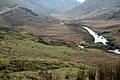
 The drovers' road to Tregaron crosses the Afon Irfon via the Irish bridge at the foot of the 'Devil's Staircase' | |
 | |
| Location | |
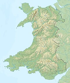
| Country | Wales |
| County | Powys |
| Physical characteristics | |
| Source | Desert of Wales |
| • location | Bryn Garw, Cambrian Mountains |
| • coordinates | 52°14′13″N3°42′54″W / 52.237°N 3.715°W |
| • elevation | 540 m (1,770 ft) |
| Mouth | River Wye |
• location | Builth Wells |
| Length | 28 mi (45 km) |
Afon Irfon (the River Irfon) is a river in Powys, Wales. It flows from the upper slopes of Bryn Garw in the Cambrian Mountains, through the Abergwesyn Valley, past the Nant Irfon National Nature Reserve in the hills above the village of Abergwesyn, and through Llanwrtyd Wells to its confluence with the River Wye at Builth Wells. The source of the Irfon is in the so-called 'Desert of Wales'.
Contents
Afon Irfon is the listed name of the Site of Special Scientific Interest in the upper reaches of the river Irfon Powys, Wales.