
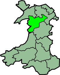
Rhufoniog was a small sub-kingdom of the Dark Ages Gwynedd, and later a cantref in medieval Wales.
Rhufoniog was a small sub-kingdom of the Dark Ages Gwynedd, and later a cantref in medieval Wales.
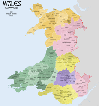
The cantref Rhos lay between it and the Irish Sea. Sometimes the two cantrefi were linked together as "Rhos and Rhufeiniog", which roughly corresponds to the territory of the old county of Denbighshire. The rivers Elwy, Clwyd and Clywedog formed a natural border to the north and east. As today, the countryside was bleak and isolated.
There were three commotes in Rhufoniog, namely Upper Aled, Lower Aled and River Aled as a border between them, and the commote Ceinmerch (also known as 'Cymeirch' or 'Ystrad') in the north-east between the River Lliwen and the River Clywedog.
The early history of the cantref is unclear. According to tradition, it was ruled by its eponymous founder Rhufon, the third son of the first King of Gwynedd, Cunedda, and his direct descendants from the year 445 until the year 540 when it was probably absorbed back into direct control of Gwynedd proper.
It formed part of the territory of the Deceangli during the Roman occupation of Wales. Later, much of the land belonged to the bishops of Bangor and Llanelwy. By the Middle Ages, Denbigh was its capital. The cantref was given to the prince Dafydd ap Gruffudd in 1277, then on his death five years later, it was given to Henry de Lacy, 3rd Earl of Lincoln. It was merged with the cantref Rhos to form the Lordship of Denbigh.
Today most of the area now lies in Denbighshire, with the western parts in Conwy.

Merionethshire or Merioneth is one of thirteen historic counties of Wales, a vice county and a former administrative county.

Montgomeryshire is one of thirteen historic counties and a former administrative county of Wales. It is named after its county town, Montgomery, which in turn is named after one of William the Conqueror's main counsellors, Roger de Montgomerie, who was the 1st Earl of Shrewsbury.

Historic Denbighshire is one of thirteen traditional counties in Wales, a vice-county and a former administrative county, which covers an area in north east Wales. It is a maritime county, bounded to the north by the Irish Sea, to the east by Flintshire, Cheshire and Shropshire, to the south by Montgomeryshire and Merionethshire, and to the west by Caernarfonshire.

The Kingdom of Gwynedd was a Welsh kingdom and a Roman Empire successor state that emerged in sub-Roman Britain in the 5th century during the Anglo-Saxon settlement of Britain.

The Kingdom of Powys was a Welsh successor state, petty kingdom and principality that emerged during the Middle Ages following the end of Roman rule in Britain. It very roughly covered the northern two-thirds of the modern county of Powys and part of today's English West Midlands. More precisely, and based on the Romano-British tribal lands of the Ordovices in the west and the Cornovii in the east, its boundaries originally extended from the Cambrian Mountains in the west to include the modern West Midlands region of England in the east. The fertile river valleys of the Severn and Tern are found here, and this region is referred to in later Welsh literature as "the Paradise of Powys".
Ardudwy is an area of Gwynedd in north-west Wales, lying between Tremadog Bay and the Rhinogydd. Administratively, under the old Kingdom of Gwynedd, it was first a division of the sub kingdom (cantref) of Dunoding and later a commote in its own right. The fertile swathe of land stretching from Barmouth to Harlech was historically used as pasture. The name exists in the modern community and village of Dyffryn Ardudwy.
A commote was a secular division of land in Medieval Wales. The word derives from the prefix cym- and the noun bod. The English word "commote" is derived from the Middle Welsh cymwt.
Rhos is a region to the east of the River Conwy in north Wales. It started as a minor kingdom then became a medieval cantref, and was usually part of the Kingdom of Gwynedd.
Perfeddwlad or Y Berfeddwlad was an historic name for the territories in Wales lying between the River Conwy and the River Dee. comprising the cantrefi of Rhos, Rhufoniog, Dyffryn Clwyd and Tegeingl. Perfeddwlad thus was also known as the Four Cantrefs.
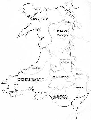
Gwent was a medieval Welsh kingdom, lying between the Rivers Wye and Usk. It existed from the end of Roman rule in Britain in about the 5th century until the Norman invasion of Wales in the 11th century. Along with its neighbour Glywyssing, it seems to have had a great deal of cultural continuity with the earlier Silures, keeping their own courts and diocese separate from the rest of Wales until their conquest by Gruffydd ap Llywelyn. Although it recovered its independence after his death in 1063, Gwent was the first of the Welsh kingdoms to be overrun following the Norman conquest.
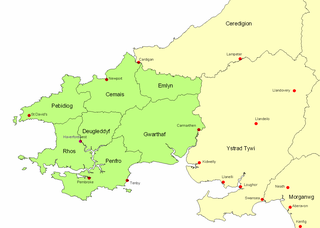
The Kingdom of Dyfed, one of several Welsh petty kingdoms that emerged in 5th-century sub-Roman Britain in southwest Wales, was based on the former territory of the Demetae. The medieval Irish narrative, The Expulsion of the Déisi, attributing the kingdom's founding to Eochaid, son of Artchorp, being forced across the Irish sea, in the 5th century; his descendants founding the line of the kings of Dyfed, down to "Tualodor mac Rígin". The Normans invaded Wales, and by 1138 incorporated Dyfed into a new shire called Pembrokeshire after the Norman castle built in the Cantref of Penfro and under the rule of the Marcher Earl of Pembroke.
Llywarch ap Llywelyn was an important medieval Welsh poet. He is also known by his bardic name, "Prydydd y Moch".
Ystrad Tywi is a region of southwest Wales situated on both banks of the River Towy, it contained places such as Cedweli, Carnwyllion, Loughor, Llandeilo, and Gwyr. Although Ystrad Tywi was never a kingdom itself, it was historically a valuable territory and was fought over by the various kings of Dyfed, Deheubarth, Seisyllwg, Gwynedd, Morgannwg and the Normans.

Rhwng Gwy a Hafren was a region of medieval Wales, located in the Welsh Marches between Powys to the north and Brycheiniog to the south. It was bounded by the rivers Wye and Severn. It covered about the same territory as Radnorshire, now part of the county of Powys. The region first came into its own in the 9th or 10th centuries, when it was ruled by leaders who operated independently of the surrounding kingdoms. After the Norman invasion, it comprised the central part of the Welsh Marches and was the site of frequent struggles between Welsh and Norman forces.
Edeirnion or Edeyrnion is an area of the county of Denbighshire and an ancient commote of medieval Wales in the cantref of Penllyn. According to tradition, it was named after its eponymous founder Edern or Edeyrn. It was included as a Welsh territory of Shropshire in the Domesday Book.

Arwystli was a cantref in mid Wales in the Middle Ages, located in the headland of the River Severn. It was chiefly associated with the Kingdom of Powys, but was heavily disputed between Powys, Gwynedd, and the Norman Marcher Lords for hundreds of years, and was the scene of many skirmishes between those groups. Like many other cantrefs and subdivisions, it was divided up by the Laws in Wales Acts in the 16th century.

Tegeingl, also known as Englefield, was a cantref in north-east Wales during the mediaeval period. It was incorporated into Flintshire following Edward I of England's conquest of northern Wales in the 13th century.
Cyfeiliog was a medieval commote in the cantref of Cynan of the Kingdom of Powys. Cynan also contained the commote of Mawddwy. Other sources refer to Cyfeiliog as a cantref in its own right, possibly as a result of Cynan's being renamed for the largest commote within it.

Mochnant was a medieval cantref in the Kingdom of Powys.
Cedewain was a medieval cantref in the Kingdom of Powys. It possibly consisted of the commotes (cymydau) of Cynan, Hafren and Uwch Hanes. Other sources give the commotes as Cedewain, Eginlle and Ceri.