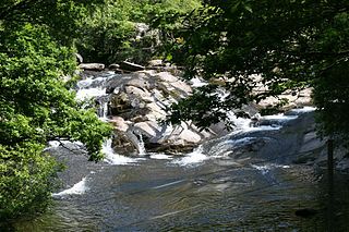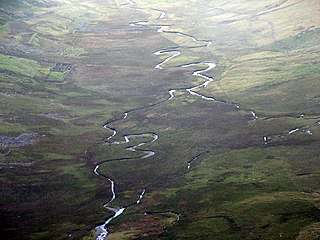
The River Clwyd is a river in Wales that rises in the Clocaenog Forest 5 mi (8 km) northwest of Corwen. Its total length is 35 mi (56 km).

The Tryweryn is a river in the north of Wales which starts at Llyn Tryweryn in the Snowdonia National Park and after 19 kilometres (12 mi) joins the river Dee at Bala. One of the main tributaries of the Dee, it was dammed in 1965 to form Llyn Celyn, drowning the village of Capel Celyn in spite of much popular and political opposition in Wales. The resulting graffiti "Cofiwch Dryweryn" near Llanrhystud became and remains a popular icon of Welsh feeling. Water is stored in Llyn Celyn in winter when flows are high, and released over the summer to maintain the flow in the Dee (water from the Dee is used as the water supply for large areas of north-east Wales, and for the Wirral and much of Liverpool in England.
The Dee regulation scheme is a system of flow balancing and quality management along the River Dee managed by a consortium of the three largest water companies licensed to take water from the river, United Utilities, Welsh Water and Severn Trent Water; together with the regulator, Natural Resources Wales.

The Afon Ogwen is a river in north-west Wales draining from some of the greatest peaks in Snowdonia before discharging to the sea on the eastern side of Bangor, Gwynedd.

The River Dwyryd is a river in Gwynedd, Wales which flows principally westwards; draining to the sea into Tremadog Bay, south of Porthmadog.

The Nantlle Valley is an area in Gwynedd, North Wales, characterised by its numerous small settlements.

Afon Seiont is a river in Gwynedd, Wales which runs into the Menai Strait.

The River Elwy is a river in Wales forming a tributary to the River Clwyd. The source of the river is sometimes said to be on the northern flank of Moel Seisiog, south-east of Llanrwst, at Ordnance Survey grid reference SH 853593. However the river only receives the name Elwy at the village of Llangernyw, where three rivers, Afon Cledwen, Afon Collen and Afon Gallen, meet to form the Elwy. It flows eastwards through Llanfair Talhaiarn and a few miles downstream from this village it is joined by a tributary, the River Aled which has its source in Llyn Aled.

Afon Eigiau is a small river in the Carneddau mountains in Snowdonia, in north-west Wales, which flows down Cwm Eigiau and into Llyn Eigiau.

Rhydyronen railway station is a request stop on the Talyllyn Railway, near Tywyn, Gwynedd in mid-Wales. It was built in 1867 to serve local farms, and the village of Bryn-crug.

Denbigh Moors is an upland region in Conwy and Denbighshire in north-east Wales, between Snowdonia and the Clwydian Range. It includes the large reservoirs Llyn Brenig and Llyn Alwen, and the Clocaenog Forest, which has one of Wales's last populations of red squirrels. It also contains the open heath Hafod Elwy Moor National Nature Reserve.

Llansannan is a rural village and community in Conwy County Borough, Wales. It lies on the bank of the River Aled and is about 8 miles to the south of Abergele and 9 miles (14 km) to the west of Denbigh. The population was 1,291 in 2001, with 67% able to speak Welsh. The figures for the 2011 census were: population 1,335 with 63% able to speak Welsh. The community includes the hamlets of Bylchau, Rhydgaled and Y Groes, and the lake Llyn Aled and reservoir Aled Isaf on Mynydd Hiraethog. Llansannan is in the traditional county of Denbighshire.

Llanfair Talhaiarn, abbreviated to Llanfair TH, is a village and community approximately 5 miles (8.0 km) south of Abergele in Conwy county borough, Wales. Until 1974 it was included in Denbighshire.

The River Dysynni is a river in mid Wales. Its source is the Tal-y-llyn Lake just south of the Cadair Idris massif and its mouth is in the Cardigan Bay area of the Irish Sea to the north of Tywyn. It measures about 16 mi (26 km) in length.
Rhyd-y-Marchogion was a farm in Llanelidan, Denbighshire. The farmhouse, attached cartshed, and garden wall as well as the farmyard buildings are Grade II listed buildings. Both the farmhouse and the farmyard buildings have now been converted into two separate homes.

Trefeurig is a community in Mid and West Wales, situated around 4 miles (6.4 km) north-east of Aberystwyth. It is a site of particular prehistoric, Roman, and Iron Age interest, and has a long history as a mining area. In 2011 the local population was estimated at around 1,771 people.

The River Banwy is a river about 19 miles (31 km) long in Powys, Wales. It is a tributary of the River Vyrnwy.
The Afon Gwyrfai is a short river in Gwynedd, Wales. For half of its length it flows through Snowdonia National Park. Exiting Llyn y Gader it flows north through the small village of Rhyd-ddu to enter the southeastern end of Llyn Cwellyn. Downstream of the lake it flows northwest past Betws Garmon, leaving the national park and continues to the southern edge of Waunfawr. It then turns slightly west to flow on to Bontnewydd beyond which it turns slightly south to enter Foryd Bay. The tidal channel within the bay flows north into the western end of the Menai Strait. Principal tributary streams include the Afon Treweunydd which contributes water from the reservoir of Llyn Ffynnon-y-gwas and from the lakes of Llyn Glas, Llyn Coch and Llyn Nadroedd in Cwm Clogwyn immediately west of the summit of Snowdon. The tidal channel of the Gwyrfai within Foryd Bay also accepts the flow of the left bank tributaries, the Afon Foryd, Afon Rhyd and Afon Carrog. The river is shadowed by the line of the Welsh Highland Railway for much of its length, and by which it is crossed four times.
The Afon Erch is a short river on the Llŷn peninsula, Gwynedd, Wales. It arises near the village of Llanaelhaearn, flowing south and southwest towards the hamlet of Llwyndyrys where it turns abruptly eastwards and curves around to the south, passing to the east of Y Ffor at Rhyd-y-gwystl. It continues towarin a SSW direction towards Abererch where despite the village name, it does not enter the sea but flows west parallel to the coast for 1 mile to Pwllheli. The Afon Rhyd-hir joins the Afon Erch within the tidal basin of Pwllheli Harbour. Its headwaters gather to the south of Llithfaen and flow south past Llannor to approach Pwllheli from the west. It is joined by the Afon Penrhos immediately west of the town, having originated around the extensive bog of Cors Geirch, a national nature reserve. Parts of the courses of each of these rivers occupy valleys that were formed by glacial meltwater. The uppermost Penrhos is a misfit stream within its valley.


