
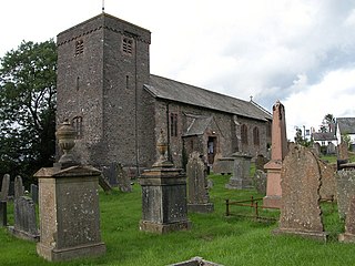
Llansantffraed (Llansantffraed-juxta-Usk) is a parish in the community of Talybont-on-Usk in Powys, Wales, near Brecon. The benefice of Llansantffraed with Llanrhystud and Llanddeiniol falls within the Diocese of St Davids in the Church in Wales.
Llangammarch Wells, or simply Llangammarch, is a village and community in Powys, Wales, lying on the Afon Irfon, and in the historic county of Brecknockshire (Breconshire).

Cilgerran is both a village, a parish, and also a community, situated on the south bank of the River Teifi in Pembrokeshire, Wales. It was formerly an incorporated market town.

Llanymynech is a village and former civil parish straddling the border between Montgomeryshire/Powys, Wales, and Shropshire, England, about 9 miles (14 km) north of the Welsh town of Welshpool. The name is Welsh for "Llan of the Monks". The village is on the banks of the River Vyrnwy, and the Montgomery Canal passes through it.

Meifod, formerly also written Meivod, is a small village, community and electoral ward seven miles (11 km) north-west of Welshpool in Montgomeryshire, Powys, Wales, on the A495 road and located in the valley of the River Vyrnwy. The River Banwy has a confluence with the Vyrnwy approximately two miles (3.2 km) to the west of the village. The village itself had a population of 317. The community includes the village of Bwlch-y-cibau and the hamlet of Allt-y-Main.

Overton or Overton-on-Dee is a village and community in Wrexham County Borough, Wales. It is situated close to the Welsh-English border on the edge of an escarpment that winds its way around the course of the River Dee, from which Overton-on-Dee derives its name.
Dinas Powys is a town and community in the Vale of Glamorgan, South Wales. Its name means "fort of the provincial place" and refers to the Iron Age hillfort which overlooks the village. Dinas Powys is 5.6 miles (9.0 km) south-west of the centre of Cardiff and is situated on the A4055 road from Cardiff to Barry, making it a popular dormitory village for city commuters. It neighbours the larger town of Penarth.

Pyle is a village and community in Bridgend county borough, Wales. This large village is served by the A48 road, and lies less than one mile from Junction 37 of the M4 motorway, and is therefore only a half-hour journey from the capital city of Wales, Cardiff. The nearest town is the seaside resort of Porthcawl. Within the Community, to the northeast of Pyle, is the adjoining settlement of Kenfig Hill, North Cornelly also adjoins Pyle and the built-up area had a population of 13,701 in 2011.

Chirbury is a village and former civil parish, now in the parish of Chirbury with Brompton, in the Shropshire district, in west Shropshire, England. It is situated in the Vale of Montgomery, close to the Wales–England border, which is to its north, west and south. The A490 and B4386 routes cross at Chirbury.

Llansantffraid-ym-Mechain is a large village in the community of Llansantffraid, in Powys, Mid Wales. It is close to the border with Shropshire in England, about 7 miles (11 km) south-west of Oswestry and 8 miles (13 km) north of Welshpool. It is on the A495 road and is at the confluence of the River Vyrnwy and the River Cain. The population as of the 2011 UK census was 1,415. The community includes the village of Deuddwr and several hamlets.

Minera is a village and community in Wrexham County Borough, Wales. It adjoins the village of Coedpoeth.

Llanfyllin is a market town and community in Powys, Wales. The community population in 2021 was 1,586 and the town's name means church or parish (llan) of St Myllin. The community includes the settlements of Bodfach, Ty Crwyn, Abernaint and several farms.

St Ishmaels or St Ishmael's is a village, parish and community close to the Milford Haven Waterway in Pembrokeshire, Wales.

Llandysilio is a small village and community in Montgomeryshire, Powys, Wales.

Isycoed is a village and community in Wrexham County Borough, Wales. It lies around 5 miles to the east of Wrexham, close to the River Dee on the border with England.

Llangunllo is a village and community in central Powys, Wales, located about 5 miles west of Knighton. It is named after St Cynllo. The population of the community at the 2011 census was 369.

Forden is a village near Welshpool in Powys, Wales, formerly in the historic county of Montgomeryshire. It forms part of the community of Forden with Leighton and Trelystan with the neighbouring settlements of Trelystan, Leighton and Kingswood.
Trallong is a village and community in Powys, Wales, in the historic county of Brecknockshire.

Michaelston-le-Pit and Leckwith is a community in the Vale of Glamorgan, Wales. It is located immediately southwest of the city of Cardiff and to the north of the Vale of Glamorgan villages of Llandough and Dinas Powys. As its name suggests, the community includes the small villages of Michaelston-le-Pit and Leckwith. The community population comprises only just under 250 adults.

Llanfihangel Talyllyn is a small village in the community of Llangors in Powys, Wales. It is also a community electoral ward for Llangors Community Council.


