The Brecon Beacons are a mountain range in Wales. The range includes South Wales's highest mountain, Pen y Fan, its twin summit Corn Du, and Craig Gwaun Taf, which are the three highest peaks in the range. The Brecon Beacons have given their name to the larger Brecon Beacons National Park, and the range itself is therefore sometimes known as the Central Beacons to differentiate the two.

The Taff Trail is a walking and cycle path that runs for 55 miles (89 km) between Cardiff Bay and Brecon in Wales. It is so named because it follows the course of the River Taff. Along much of its length, it follows the National Cycle Network Route 8 that continues to Holyhead, and is substantially off-road.

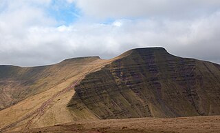
Pen y Fan is the highest peak in South Wales, situated in Brecon Beacons National Park. At 886 metres (2,907 ft) above sea-level, it is also the highest British peak south of Cadair Idris in Snowdonia. It is the highest point of the historic county of Brecknockshire. The twin summits of Pen y Fan and Corn Du at 873 metres (2,864 ft) were formerly referred to as Cadair Arthur or 'Arthur's Seat'.

Abercraf is a village in Powys, Wales, in the community of Ystradgynlais and within the historic boundaries of the county of Brecknockshire.

Sarn Helen refers to several stretches of Roman road in Wales. The 160-mile (260 km) route, which follows a meandering course through central Wales, connects Aberconwy in the north with Carmarthen in the west. Despite its length, academic debate continues as to the precise course of the Roman road. Many sections are now used by the modern road network while other parts are still traceable. However, there are sizeable stretches that have been lost and are unidentifiable.

The Black Mountain is a mountain range in South, Mid and West Wales, straddling the administrative boundary between Carmarthenshire and Powys and forming the westernmost range of the Brecon Beacons National Park. Its highest point is Fan Brycheiniog at 802 metres or 2,631 ft. The Black Mountain also forms a part of the Fforest Fawr Geopark.

Bethlehem is a tiny farming village in the county of Carmarthenshire, Wales, lying in the Tywi Valley northeast of Llandeilo and southwest of Llangadog but on the opposite side of the river from the busy London to Haverfordwest road, the A40.

The Beacons Way is a waymarked long distance footpath in the Brecon Beacons National Park, Wales. It is a linear route which runs for 99 miles (159 km) east to west through the National Park, and passes many of the most important landmarks and mountain peaks in the mountain range. It also includes a few of the towns in the park as well as popular attractions such as Carreg Cennen Castle near Llandeilo at the western end of the path.

Coelbren is a small rural village within the community of Tawe Uchaf in southernmost Powys, Wales. It lies on the very northern edge of the South Wales Coalfield some six miles north-east of Ystradgynlais and just outside the southern boundary of the Brecon Beacons National Park. It is known for Henrhyd Falls, a 27m high waterfall which serves as a National Trust-managed visitor attraction on the Nant Llech. To the east of the village flows the Afon Pyrddin which plunges over two more spectacular falls.

Fforest Fawr is an extensive upland area in the county of Powys, Wales. Formerly known as the Great Forest of Brecknock in English, it was a royal hunting area for several centuries but is now used primarily for sheep grazing, forestry, water catchment and recreation. It lies within the Brecon Beacons National Park.
The National Park Visitor Centre, commonly known as the Brecon Beacons Mountain Centre, is a visitor centre managed by the Brecon Beacons National Park Authority, located in the village of Libanus some 8 km / 5 mi south-west of Brecon in Powys, south Wales. The centre provides information and interpretation for visitors to the area.
Fforest Fawr Geopark is a Geopark in the Brecon Beacons National Park, south Wales. It is the first designated Geopark in Wales having gained membership of both the European Geoparks Network and the UNESCO-assisted Global Network of National Geoparks in October 2005. The Geopark aims to promote and support sustainable tourism and other opportunities to improve the economy of the area whilst safeguarding the natural environment. Its aims largely coincide with the statutory duties and purpose of the National Park within which it sits.

Mynydd Illtud is an extensive area of common land near Libanus, Powys, Wales, located in the Brecon Beacons National Park and some three miles south-west of Brecon. The common is an undulating plateau lying between 330 and 370 metres above sea level. Its highest points are 381 metres (1,250 ft) at Allt Lom and 367 metres (1,204 ft) at Twyn y Gaer trig point overlooking the valley of the River Usk. Twyn y Gaer is the site of an Iron Age hill fort.

The Grwyne Fawr is a river in the Brecon Beacons National Park in south Wales. A section of it forms the administrative border between Powys and Monmouthshire and also of the historic counties of Brecon and Monmouth. The river and its major tributary the Grwyne Fechan flow into the River Usk at Glangrwyney.

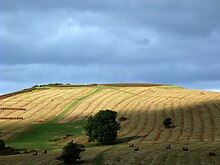
Y Garn Goch is a hill in the Brecon Beacons National Park in the east of Carmarthenshire, Wales. The name means the 'red cairn'. It lies near the village of Bethlehem, three miles southwest of Llangadog and four miles east of Llandeilo on the southern side of the broad Towy Valley. It is also commonly known as either Garn Goch or Carn Goch. Current owners and land managers are the Brecon Beacons National Park Authority.
Trap is a hamlet in the county of Carmarthenshire in southwest Wales, located on the western border of the Brecon Beacons National Park, around four miles southeast of the town of Llandeilo. It is unclear whether the name – which often appears as Trapp on maps, although the spelling with a single p is generally preferred locally – refers to a fish-trap, a water-trap (mill-leat), or, given that the village is in Cwm Lladron, an ambush point.
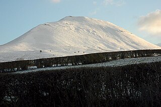
Mynydd Troed is a hill in the Black Mountains of the Brecon Beacons National Park in Powys, south Wales. Its name literally translates to "Foot Mountain," based how it appears when viewed from the Allt Mawr ridge.
Waterfall Country is a name often given to the upper reaches of the Vale of Neath in South Wales. The tourist area around the head of the valley has an unusually large number of publicly accessible waterfalls. The area is not officially defined but generally includes the group of falls on the Nedd Fechan, Pyrddin, Hepste and Mellte rivers, all of which lie between the villages of Pontneddfechan and Ystradfellte in the Brecon Beacons National Park.

Glyn Tarell is a valley and a community in the county of Powys, Wales, and the historic county of Brecknockshire. It is in the Brecon Beacons National Park and at the northern edge of the Brecon Beacons mountains.