
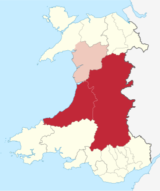
Powys is a county and preserved county in Wales. It borders Gwynedd, Denbighshire, and Wrexham to the north; the English ceremonial counties of Shropshire and Herefordshire to the east; Monmouthshire, Blaenau Gwent, Merthyr Tydfil, Caerphilly, Rhondda Cynon Taf, and Neath Port Talbot to the south; and Carmarthenshire and Ceredigion to the west. The largest settlement is Newtown, and the administrative centre is Llandrindod Wells.

The A44 is a major road in the United Kingdom that runs from Oxford in southern England to Aberystwyth in west Wales.

Montgomeryshire is one of thirteen historic counties and a former administrative county of Wales. It is named after its county town, Montgomery, which in turn is named after one of William the Conqueror's main counsellors, Roger de Montgomerie, who was the 1st Earl of Shrewsbury.
Mid Wales or Central Wales is a region of Wales, encompassing its midlands, in-between North Wales and South Wales. The Mid Wales Regional Committee of the Senedd covered the unitary authority areas of Ceredigion and Powys and the area of Gwynedd that had previously been the district of Meirionnydd. A similar definition is used by the BBC. The Wales Spatial Plan defines a region known as "Central Wales" which covers Ceredigion and Powys.

The Afon Rheidol is a river in Ceredigion, Wales, 19 miles (31 km) in length. The source is Plynlimon. Receiving an average annual rainfall of 40 inches (1.02 m), Plynlimon is also the source of both the Wye and the Severn.

Sycharth is a motte and bailey castle and town in Llansilin, Powys, Wales. Until 1996 Sycharth was in the historic county of Denbighshire, but was then transferred to the Shire area of Montgomeryshire within Powys. Sycharth Castle was the birthplace of Owain Glyndŵr.

Llansilin is a village and local government community in Montgomeryshire, Powys, Wales, 5 miles (8 km) west of Oswestry. The community, which includes Llansilin village, a large rural area and the hamlets of Moelfre and Rhiwlas as well as the remote parish of Llangadwaladr, had a population of 648 at the 2001 census, increasing to 698 at the 2011 Census. There is also an electoral ward including the nearby village of Llanrhaeadr-ym-Mochnant with a population of 2,295.

Brecon and Radnorshire is a constituency of the Senedd. It elects one Member of the Senedd by the first past the post method of election. Also, however, it is one of eight constituencies in the Mid and West Wales electoral region, which elects four additional members, in addition to eight constituency members, to produce a degree of proportional representation for the region as a whole. It is currently represented by James Evans MS, of the Conservatives who has been the MS since May 2021.

Montgomeryshire is a constituency of the Senedd. It elects one Member of the Senedd by the first past the post method of election. Also, however, it is one of eight constituencies in the Mid and West Wales electoral region, which elects four additional members, in addition to eight constituency members, to produce a degree of proportional representation for the region as a whole.

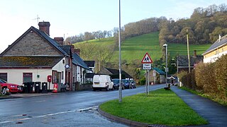
Nant Glas is a village in the Elan Valley near Rhayader and Llandrindod Wells in Powys, Wales. It is on a side road between the A44 to the northeast and the A470 to the southwest. There is a small chapel at the southern end of the village.

The A490 is a road in the United Kingdom running from Churchstoke, Powys to Llanfyllin, also in Powys. The road runs for a short distance through Shropshire in England.
Boughrood is a village in the community of Glasbury in Powys, Wales.

Merthyr Cynog is a hamlet and a community in the modern county of Powys, Wales, in the historic county of Brecknockshire. The population of the community at the 2011 Census was 245.
Llangadwaladr, formerly spelt Llancadwaladr in some sources, is an isolated mountain parish in Powys, Wales. It was formerly in the historic county of Denbighshire, and from 1974 to 1996 was in Clwyd. Some 7 miles west of the nearest town, Oswestry, it covers an area of sparsely settled hill farming country around the valley of the Afon Ysgwennant beneath Gyrn Moelfre.

Duhonw is a rural community in Powys, Wales, to the south of Builth Wells, in the historic county of Breconshire. Covering an area of 4,376 hectares (16.90 sq mi) and including scattered farms and dwellings, it is bounded to its north by the Afon Irfon, to its south by Mynydd Epynt and Banc y Celyn (472m) and to its east the rivers Duhonw and Wye. Llangammarch Wells' is to its west.

Gyrn Castle is a Grade II-listed castellated mansion in Llanasa in Flintshire.

Disserth and Trecoed is an electoral ward and community in central Powys, Wales. It has a population of 1,239 according to the 2011 UK census.

Pen-y-Bont-Fawr is a small village and community in Montgomeryshire, Powys, Wales located in the Tanat valley. In the 2011 UK Census it had a population of 440 with 58% born in England and 39% in Wales.

Painscastle is a village and community in Powys, Wales which takes its name from the castle at its heart. It lies between Builth and Hay-on-Wye, approximately 3 miles from the Wales-England border today. The community also includes the villages and settlements of Rhosgoch, Bryngwyn, Llandeilo Graban and Llanbedr. The population as of the 2011 UK Census was 524. It is represented by the Painscastle and Rhosgoch Community Council, which comprises eight community councillors. It is included in the Glasbury electoral ward for Powys County Council elections.

Llanwrtyd Wells is the name of an electoral ward in mid Powys, Wales. It covers three local government communities and elects a councillor to Powys County Council.
