Pentre Bychan

Last updated

Pentre Bychan
Pentre Bychan from Bersham Tip (geograph 2485644).jpg
Pentre Bychan
Wrexham UK location map.svg
Red pog.svg
Pentre Bychan
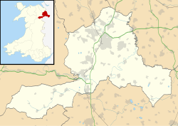
Location within Wrexham
OS grid reference SJ306477
Community
Principal area
Preserved county
Country Wales
Sovereign state United Kingdom
Post town WREXHAM
Postcode district LL14
Dialling code 01978
Police North Wales
Fire North Wales
Ambulance Welsh
UK Parliament
Senedd Cymru – Welsh Parliament
List of places
UK
Wales
Wrexham
53°01′19″N3°02′06″W / 53.022°N 3.035°W / 53.022; -3.035

Pentre Bychan ( Welsh for 'little village') is a semi-rural hamlet in Wrexham County Borough, Wales.

Contents

Variously spelled as either one word or two (Pentre Bychan or Pentrebychan), it is situated between Rhostyllen and Johnstown in the ward and community of Esclusham, some 4 km south-west of Wrexham city centre.

History

The ancient monument Offa's Dyke runs through Pentre Bychan.

The Pentrebychan estate was once of great importance in the area. The 16th-century house originally belonged to the Tegin family. It was a single-storey building, half-timbered with wattle and daub.

In 1620 the estate was purchased by Hugh Meredith. The Meredith family, who owned several local coal mines, occupied the estate until 1802 when Thomas Meredith, the last of the male line, died. The family traced their ancestry to Bleddyn ap Cynfyn, Prince of Powys. The Hall and estate were described as among the most extensive in the area. Many of the Welsh place names on the estate in the days of the early Merediths are extant today.

The estate passed into the Warter family. Joseph Warter (died 1811) married Margaretta Elizabeth Meredith, daughter and heiress of Thomas Meredith. His son Henry Warter succeeded to the estate, took the additional surname Meredith, and served as High Sheriff of Denbighshire in 1844. [1]

In 1823 the hall was replaced with a larger, three storey, dressed-stone building with gables, which had a stable block and coachhouse at the rear. The hall was surrounded by landscaped gardens which included a brick dovecote which dated back to 1721, a "fine example of an eighteenth century dovecote", Grade II listed since 1977.

The notable Arts & Crafts architect Frank Shayler designed a pair of houses of rustic brick beneath sand-faced clay tiles in the grounds of the former Pentrebychan Hall in 1936, developed speculatively. Originally intended to be a group of twelve, initial sales were slow due to being marketed at a relatively high value. As a consequence, only two were built with construction subsequently halted by the Second World War.

The hall was used to house refugees during the war. It was purchased in 1948 by Denbighshire County Council, who at the time administered the area, but was demolished in 1963.

The Wrexham crematorium was built on the site, on Pentre Bychan Road, off Smithy Lane, and opened in 1966. The house's magnificent gardens and woods remain, together with the dovecote; they are in the crematorium's 40 acre (16 ha) grounds and are maintained as semi natural woodland (including three pools and Pentrebychan brook).

Animal species located in the grounds include heron, badgers, buzzards, snakes, ducks and owls. The grounds also consist of one ungrazed paddock which is kept as a wild meadow and an arboretum. A section of Offa's Dyke passes through the crematorium grounds. [2]

Local businesses

Hafren Dyfrdwy, (previously Wrexham and East Denbighshire Water Company, Wrexham Water and Dee Valley Water) and Scottish Power are prominent businesses located on the Wrexham Road at Packsaddle Bridge.

Notable residents

Countryside Walk

Pentre Bychan can be visited as part of one of Wrexham County Council's Countryside Walks. [3]

Related Research Articles

<span class="mw-page-title-main">Wrexham</span> City in north-east Wales

Wrexham is a city and the administrative centre of Wrexham County Borough in Wales. It is located between the Welsh mountains and the lower Dee Valley, near the border with Cheshire in England. Historically in the county of Denbighshire, and later the county of Clwyd in 1974, it has been the principal settlement of Wrexham County Borough since 1996.

<span class="mw-page-title-main">Chirk</span> Town in Wales

Chirk is a town and community in Wrexham County Borough, Wales, 10 miles south of Wrexham, between it and Oswestry. At the 2011 census, it had a population of 4,468. Historically in the traditional county of Denbighshire, and later Clwyd, it has been part of Wrexham County Borough since a local government reorganisation in 1996. The border with the English county of Shropshire is immediately south of the town, on the other side of the River Ceiriog.

<span class="mw-page-title-main">Wrexham County Borough</span> County borough in Wales

Wrexham County Borough is a county borough, with city status, in the north-east of Wales. It borders the English ceremonial counties of Cheshire and Shropshire to the east and south-east respectively, Powys to the south-west, Denbighshire to the west and Flintshire to the north-west. The city of Wrexham is the administrative centre. The county borough is part of the preserved county of Clwyd.

<span class="mw-page-title-main">Rhosllanerchrugog</span> Village in Wales

Rhosllanerchrugog is a village and community in Wrexham County Borough, Wales. It lies within the historic county of Denbighshire. The entire built-up area including Penycae, Ruabon and Cefn Mawr had a population of 25,362.

<span class="mw-page-title-main">Ruabon</span> Village in Wales

Ruabon is a village and community in Wrexham County Borough, Wales. The name comes from Rhiw Fabon, rhiw being the Welsh word for "slope" or "hillside" and Fabon being a mutation from St Mabon, the original church name, of earlier, Celtic origin. An older English spelling, Rhuabon, can sometimes be seen.

<span class="mw-page-title-main">Acton, Wrexham</span> Community in Wrexham County Borough, Wales

Acton is a suburb and community in Wrexham, Wrexham County Borough, Wales. It spans the north-eastern part of Wrexham. The area is largely residential and at its centre, lies Acton Park, the location of the former Acton Hall.

<span class="mw-page-title-main">Abenbury</span> Community in Wrexham County Borough, Wales

Abenbury is a community in Wrexham County Borough, Wales. It is situated south-east of Wrexham city and includes the village of Pentre Maelor and part of the Wrexham Industrial Estate.

<span class="mw-page-title-main">Erddig</span> Country house and estate in Wrexham, North Wales

Erddig Hall is a Grade-I listed National Trust property near Wrexham, North Wales. Standing 2 miles (3.2 km) south of the city centre, it comprises a country house built, during the 17th and 18th centuries, amidst a 1,900-acre (770 ha) estate, which includes a 1,200-acre (490 ha) landscaped pleasure park and the earthworks of a Norman motte-and-bailey castle.

<span class="mw-page-title-main">Ponciau</span> Village in Wales

Ponciau is a village within the community of Rhosllanerchrugog, Wrexham County Borough, Wales. It is close to the villages of Legacy, Pentre Bychan, and Johnstown and is overlooked by Ruabon Mountain.

<span class="mw-page-title-main">Brymbo</span> Village in Wales

Brymbo is a village and community in Wrexham County Borough, Wales. It lies in the hilly country to the west of Wrexham city, largely surrounded by farmland.

<span class="mw-page-title-main">Erbistock</span> Village in Wales

Erbistock is a village and community in Wrexham County Borough, Wales. The village lies on the banks of the River Dee.

<span class="mw-page-title-main">Stansty</span> Area of Wrexham, Wales

Stansty is an area and electoral ward in Wrexham County Borough, Wales, lying to the immediate north-west of the city of Wrexham. It is a former civil parish and township. Stansty is also an electoral ward to Wrexham County Borough Council. The ward population as taken at the 2011 Census was 2,114.

<span class="mw-page-title-main">Garden Village, Wrexham</span> Suburb and ward of Wrexham, Wales

Garden Village is a suburb of the city of Wrexham and an electoral division (ward) in the community of Rhosddu in Wrexham County Borough, Wales. The population of the ward at the 2011 census was 2,035 It lies to the west of Chester Road and borders the wards of Stansty to the south and east, Gwersyllt East and South to the north west, Little Acton and Acton to the west, and a small section of Gresford to the north.

<span class="mw-page-title-main">Plas Coch</span> Area of Wrexham

Plas Coch is an area of the community of Rhosddu, in the city of Wrexham, Wales. A major retail and educational area of Wrexham, it lies to the north-west of Wrexham city centre. Formerly known as Lower Stansty, the term has fallen out of use in preference for Plas Coch in recent years, likely due to the popular retail area which shares its name.

<span class="mw-page-title-main">History of Wrexham</span>

The city of Wrexham in north-east Wales has a history dating back to ancient times. The former market town was the site of heavy industry in the 19th and 20th centuries, and is now an active commercial centre. Wrexham was granted city status in 2022.

<span class="mw-page-title-main">Rhostyllen</span> Village in Wrexham County Borough, Wales

Rhostyllen is a village in Wrexham County Borough, Wales, south-west of the city of Wrexham. At the time of the 2001 census, area Wrexham 014A, which includes Rhostyllen itself, had a population of 1,383 in 599 households.

<span class="mw-page-title-main">Trevor, Wrexham</span> Village in Wrexham County Borough, Wales

Trevor is a village in Wrexham County Borough, Wales. It is situated in the scenic Vale of Llangollen, on the A539 between Llangollen and Wrexham, in the community of Llangollen Rural, and in the historic county of Denbighshire.

<span class="mw-page-title-main">Offa, Wrexham</span> Community in Wrexham County Borough, Wales

Offa is a community and electoral ward in Wrexham County Borough, Wales, covering most of the south-western portion of the city of Wrexham. It is bordered by the communities of; Rhosddu, and Caia Park to the north, Abenbury to the east, Esclusham, and Marchwiel to the south, and Broughton, Coedpoeth, and Gwersyllt to the west.

<span class="mw-page-title-main">Tŷ Mawr Country Park</span> Country park in Wrexham County Borough

Tŷ Mawr Country Park is a country park and farm park near Cefn Mawr in Wrexham County Borough, Wales. The country park lies between Cefn-bychan and Newbridge to the north, the River Dee to the south and west, and the Cefn Viaduct carrying the Shrewsbury–Chester line to the east.

References

  1. Burke, Bernard; Burke, Ashworth Peter (1894). A genealogical and heraldic history of the landed gentry of Great Britain & Ireland. London : Harrison. p. 2146.
  2. http://www.wrexham.gov.uk/english/env_services/community_services/pentrebychan_crematorium.htm Wrexham Council website page.
  3. "Self-guided walks | Wrexham County Borough Council".