Johnstown, Wrexham

Last updated

Johnstown
St. Mary's Church, Johnstown - geograph.org.uk - 830515.jpg
St. Mary's Church, Johnstown
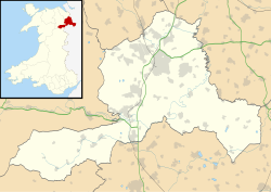
Wrexham UK location map.svg
Red pog.svg
Johnstown
Location within Wrexham
Population3,266 (2011)
OS grid reference SJ303463
Community
Principal area
Country Wales
Sovereign state United Kingdom
Post town WREXHAM
Postcode district LL14
Dialling code 01978
Police North Wales
Fire North Wales
Ambulance Welsh
UK Parliament
Senedd Cymru – Welsh Parliament
List of places
UK
Wales
Wrexham
53°00′32″N3°02′17″W / 53.009°N 3.038°W / 53.009; -3.038

Johnstown is a village (and former electoral ward) in Wrexham County Borough, Wales, and forms part of the old coal mining community of Rhosllannerchrugog. It is thought to have been named after John Bury, a mid 19th century member of Wrexham's first Town Council, who built a number of houses in the area. [1]

The disused coal mine at Hafod is situated to the east of the village and the mine's former coal tip has now been converted to a country park, Bonc yr Hafod. The nearby clay quarry was used as a landfill site for waste from Liverpool. It now takes waste from anywhere after the transfer to Cory's.

The village has approximately 4,000 inhabitants, living in 1,300 households which are split into three main areas, the Moreton Estate, Nant Parc and the older part of the village (taken from police figures). The ward population at the 2011 census was 3,266. [2]

Johnstown is a located on the historic earth work of Offa's Dyke.

There is only one school in Johnstown: Ysgol Yr Hafod.

There are two public houses in Johnstown; The New Inn and The Grapes

In April 2012, a planning application was submitted by developers Capital & Centric Plc for a new supermarket on the disused Griflex industrial unit, potentially creating 300 jobs for the area. [3]
Related Research Articles

<span class="mw-page-title-main">Neston</span> Market town and civil parish in Cheshire, England

Neston is a market town and civil parish on the Wirral Peninsula, in Cheshire, England. It is part of the unitary authority of Cheshire West and Chester. The civil parish and wider suburban area includes Parkgate to the north west and Little Neston, Ness and part of Burton to the south.

<span class="mw-page-title-main">Wrexham County Borough</span> County borough in Wales

Wrexham County Borough is a county borough, with city status, in the north-east of Wales. It borders the English ceremonial counties of Cheshire and Shropshire to the east and south-east respectively, Powys to the south-west, Denbighshire to the west and Flintshire to the north-west. The city of Wrexham is the administrative centre. The county borough is part of the preserved county of Clwyd.

<span class="mw-page-title-main">Glanamman</span> Village in Carmarthenshire, Wales

Glanamman is a mining village in the valley of the River Amman in Carmarthenshire, Wales. Glanamman has long been a stronghold of the Welsh language; village life is largely conducted in Welsh. Like the neighbouring village of Garnant it experienced a coal-mining boom in the 19th and early 20th centuries, but the last big colliery closed in 1947 and coal has been extracted fitfully since then.

<span class="mw-page-title-main">Risca</span> Human settlement in Wales

Risca is a town in the Caerphilly County Borough and the historic boundaries of Monmouthshire in south-east Wales. Risca has a railway station, opened on the Ebbw Valley Railway in February 2008, after a gap of 46 years. It is split into two communities; Risca East and Risca West. It has a population of 11,700. The town is now part of the Cardiff Capital Region which has a combined population of 1,543,293. Cardiff the capital of Wales can be reached in under 28 minutes from the nearby railway station of Risca and Pontymister station which reopened in 2008 after a gap of nearly 60 years.

<span class="mw-page-title-main">Rhosllanerchrugog</span> Village in Wales

Rhosllanerchrugog is a village and community in Wrexham County Borough, Wales. It lies within the historic county of Denbighshire. The entire built-up area including Penycae, Ruabon and Cefn Mawr had a population of 25,362.

<span class="mw-page-title-main">Ruabon</span> Village in Wales

Ruabon is a village and community in Wrexham County Borough, Wales. The name comes from Rhiw Fabon, rhiw being the Welsh word for "slope" or "hillside" and Fabon being a mutation from St Mabon, the original church name, of earlier, Celtic origin. An older English spelling, Rhuabon, can sometimes be seen.

<span class="mw-page-title-main">Gresford</span> Village in Wales

Gresford is a village and community in Wrexham County Borough, Wales.

The Wrexham and Minera Railway or Wrexham and Minera Branch was a railway line in North Wales between the city of Wrexham, the village of Brymbo where it served the Brymbo Steelworks, and the lead mines and limeworks at Minera. A further branch ran from Brymbo to Coed Talon, where it connected with lines to Mold. The system was constructed in several stages between 1844 and 1872, while the various lines making up the system closed in 1952, 1972 and 1982.

<span class="mw-page-title-main">Minera</span> Village in Wales

Minera is a village and community in Wrexham County Borough, Wales. It adjoins the village of Coedpoeth.

<span class="mw-page-title-main">Garnant</span> Village in Carmarthenshire, Wales

Garnant is a mining village in the valley of the River Amman in Carmarthenshire, Wales, north of Swansea. Like the neighbouring village of Glanamman it experienced a coal-mining boom in the 19th and early 20th centuries, but the last big colliery closed in 1936 and coal has been extracted fitfully since then. The village has the only Commissioners' church built in southwest Wales, traditionally a Methodist region.

<span class="mw-page-title-main">Hope, Flintshire</span> Village in Flintshire, Wales

Hope is a small village and community in Flintshire, north-east Wales. The village is located approximately 3 miles / 4.5 km from the Wales-England border, on the course of the River Alyn, and less than 5 miles from Wrexham.

<span class="mw-page-title-main">Ponciau</span> Village in Wales

Ponciau is a village within the community of Rhosllanerchrugog, Wrexham County Borough, Wales. It is close to the villages of Legacy, Pentre Bychan, and Johnstown and is overlooked by Ruabon Mountain.

<span class="mw-page-title-main">Brymbo</span> Village in Wales

Brymbo is a village and community in Wrexham County Borough, Wales. It lies in the hilly country to the west of Wrexham city, largely surrounded by farmland.

<span class="mw-page-title-main">Gwersyllt</span> Village in Wales

Gwersyllt is an urban village and community in Wrexham County Borough, Wales.

<span class="mw-page-title-main">Stansty</span> Area of Wrexham, Wales

Stansty is an area and electoral ward in Wrexham County Borough, Wales, lying to the immediate north-west of the city of Wrexham. It is a former civil parish and township. Stansty is also an electoral ward to Wrexham County Borough Council. The ward population as taken at the 2011 Census was 2,114.

<span class="mw-page-title-main">Rhostyllen</span> Village in Wrexham County Borough, Wales

Rhostyllen is a village in Wrexham County Borough, Wales, south-west of the city of Wrexham. At the time of the 2001 census, area Wrexham 014A, which includes Rhostyllen itself, had a population of 1,383 in 599 households.

<span class="mw-page-title-main">Esclusham</span> Community in Wrexham County Borough, Wales

Esclusham is a community and electoral ward in Wrexham County Borough, Wales.

<span class="mw-page-title-main">Bersham Colliery</span> Former coal mine in Wrexham, Wales

Bersham Colliery was a large coal mine located near Rhostyllen in Wrexham County Borough, Wales. The mine accessed seams found in the Denbighshire Coalfield.

<span class="mw-page-title-main">Bonc yr Hafod</span> Country park in Wrexham County Borough

Bonc yr Hafod is a country park, on the former site of Hafod Colliery, near Johnstown and Pentre Bychan in Wrexham County Borough, Wales. The country park is centred on a former spoil tip hill, known locally as "Picnic Mountain", rising up 150 metres (490 ft). The country park is 90 acres (0.36 km2) in size of mainly woodlands and grasslands. The park is home to one of the largest community woodlands in North East Wales.

<span class="mw-page-title-main">Stryt Las Park</span> Park in Wrexham County Borough

Stryt Las Park is a park situated between Johnstown and Rhosllanerchrugog, in Wrexham County Borough, Wales. It is named after Stryt Las, the street which borders the park to its south. The park is situated on a former colliery and landfill site.

References

  1. Transactions of the Denbighshire Historical Society, vol 14 (1965), 182
  2. "Ward population 2011" . Retrieved 18 November 2015.
  3. "The Leader - News from Wrexham & Flintshire - 'New supermarket could create up to 300 jobs'". Archived from the original on 3 April 2012. Retrieved 27 June 2012.