Pen-y-cae, Wrexham

Last updated

Pen-y-cae
Zion English Baptist Church, Penycae - geograph.org.uk - 729952.jpg
Zion English Baptist Church, Pen-y-cae
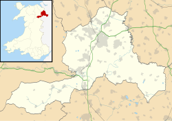
Wrexham UK location map.svg
Red pog.svg
Pen-y-cae
Location within Wrexham
Population3,389 (2011)
OS grid reference SJ279452
Community
  • Penycae
Principal area
Country Wales
Sovereign state United Kingdom
Post town WREXHAM
Postcode district LL14
Dialling code 01978
Police North Wales
Fire North Wales
Ambulance Welsh
UK Parliament
Senedd Cymru – Welsh Parliament
List of places
UK
Wales
Wrexham

52°59′56″N3°04′23″W / 52.999°N 3.073°W / 52.999; -3.073

Contents

Wales Wrexham Community Penycae map.svg
Map of the community
Pen-y-cae Community Council logo Logo Pen-y-cae Community Council.gif
Pen-y-cae Community Council logo

Pen-y-cae (sometimes spelled Penycae) is a village and community in Wrexham County Borough, Wales. The population of the community taken at the 2011 census was 3,389. [1] It adjoins the larger village of Rhosllanerchrugog.
Etymology

Pen-y-cae means 'head of the field' or 'end of the field'. Although often written as one word without hyphens, in its correct form the name is hyphenised due to the definite article 'y' preceding a single-syllable element. [2]

History

St Thomas' Parish Church Penycae st-thomas.jpg
St Thomas' Parish Church

The village was part of the ancient parish of Ruabon and the district was known as Dynhinlle Uchaf (but also known as Y Dref Fechan or Cristionydd Fechan).

The new parish of Pen-y-cae was formed 1879, from parts of the existing parishes of Ruabon, Rhosllanerchrugog and Rhosymedre. St Thomas' Church Penycae, then-Parish Church, was consecrated in 1878. However, most of the population of the parish were nonconformists and attended the Baptist chapels of Salem and Sion in Groes; the Calvinistic Methodist chapels in Groes and Tainant; the Wesleyan chapel of Soar in Stryt Issa; or the Primitive Methodist chapel in Copperas. Below is a list of Chapels in the community some moved locations over time and only three are currently active as of 2024 [3]

Church in wales:

Baptists:

Methodists:

"Methodistaidd Soar Stryt-Isa"

Other:

Industry/employment

The Pen-y-cae Upper Reservoir Penycaetop.jpg
The Pen-y-cae Upper Reservoir

Coal was extracted from pits at Plas Bennion, Wynn Hall, Afon Eitha, Cristionydd, Groes and Plas Isaf; zinc was worked at Copperas. The area descending towards Acrefair was known as "The Delph", it was served by extensions of the Ruabon Brook Tramway but these were mostly defunct by the mid-20th century.

Most inhabitants find employment outside the village in Wrexham with only a few local shops or public buildings providing jobs.

Dee Valley Water operates two reservoirs in Pen-y-cae: Pen-y-cae Upper and Pen-y-cae Lower. [4]

Transport

Wright & Son, ran a bus service from Pen-y-cae to Wrexham via Rhos, and later via Ponciau also. When the bus industry was de-regulated in 1986 there was fierce competition between Wright's and the much larger Crosville company. Wright's, the last surviving independent local company, ceased operations in 1993 leaving Crosville as the sole service provider in the Wrexham area.

Arriva currently operates a bus service to Wrexham Bus Station. [5] The nearest railway station is Ruabon, located two miles away from the village, which has daily services towards Chester and Shrewsbury.

Notable residents

Related Research Articles

<span class="mw-page-title-main">Wrexham County Borough</span> County borough in Wales

Wrexham County Borough is a county borough, with city status, in the north-east of Wales. It borders the English ceremonial counties of Cheshire and Shropshire to the east and south-east respectively along the England–Wales border, Powys to the south-west, Denbighshire to the west and Flintshire to the north-west. The city of Wrexham is the administrative centre. The county borough is part of the preserved county of Clwyd.

<span class="mw-page-title-main">Rhosllanerchrugog</span> Village in Wales

Rhosllanerchrugog is a village and community in Wrexham County Borough, Wales. It lies within the historic county of Denbighshire. The entire built-up area including Penycae, Ruabon and Cefn Mawr had a population of 25,362.

<span class="mw-page-title-main">Ruabon</span> Village in Wales

Ruabon is a village and community in Wrexham County Borough, Wales. The name comes from Rhiw Fabon, rhiw being the Welsh word for "slope" or "hillside" and Fabon being a mutation from St Mabon, the original church name, of earlier, Celtic origin. An older English spelling, Rhuabon, can sometimes be seen.

<span class="mw-page-title-main">Clwyd South (UK Parliament constituency)</span> UK Parliamentary constituency, 1997–2024

Clwyd South was a constituency of the House of Commons of the Parliament of the United Kingdom (Westminster). The constituency was created in 1997, and it elected one Member of Parliament (MP) by the first past the post method of election.

<span class="mw-page-title-main">Coedpoeth</span> Village in Wales

Coedpoeth is a village and community in Wrexham County Borough, Wales. The built-up area with Minera had a population of 5,723 in the 2011 census.

Wynn Hall is a 17th-century house in the old hamlet of Bodylltyn in Ruabon, Wrexham, Wales standing at the junction of the Penycae Road and Plas Bennion Road. It was built in about 1649 by William Wynn and is a Grade II* listed building.

<span class="mw-page-title-main">Ponciau</span> Village in Wales

Ponciau is a village within the community of Rhosllanerchrugog, Wrexham County Borough, Wales. It is close to the villages of Legacy, Pentre Bychan, and Johnstown and is overlooked by Ruabon Mountain.

<span class="mw-page-title-main">Brymbo</span> Village in Wales

Brymbo is a village and community in Wrexham County Borough, Wales. It lies in the hilly country to the west of Wrexham city, largely surrounded by farmland.

Wrexham was a rural district in the administrative county of Denbighshire from 1894 and 1974.

<span class="mw-page-title-main">Llanfechain</span> Village in northern Powys, Wales

Llanfechain is a village and community in Powys, Wales, on the B4393 road between Llanfyllin and Llansantffraid-ym-Mechain. Historically it belonged to Montgomeryshire. The River Cain runs through. The population of 465 at the 2011 Census was estimated at 476 in 2019.

<span class="mw-page-title-main">Caradog Roberts</span> Welsh musician

Caradog Roberts was a Welsh composer, organist and choirmaster.

<span class="mw-page-title-main">Mechell, Anglesey</span> Community in Anglesey, Wales

Mechell is a community in the north of the Isle of Anglesey, Wales. Llanfechell is the largest village within the community area. Tregele, Llanfflewyn, Mynydd Mechell, Bodewryd, Rhosbeirio and Carreglefn have a more dispersed settlement pattern. The antiquity of these settlements is shown by the presence of 6 medieval churches and some 16 more ancient sites dating back into prehistory.

<span class="mw-page-title-main">Griffith William Hughes</span> Welsh accountant and musician

Griffith William Hughes was a Welsh accountant and musician.

<span class="mw-page-title-main">Plas Madoc</span> Housing estate in Wrexham County Borough, Wales

Plas Madoc is a housing estate and former electoral ward near Acrefair, in the Cefn community in Wrexham County Borough, Wales. It is located seven miles to the south-west of Wrexham, and contains The Land adventure playground, and a community-run leisure centre with a swimming pool. The area is one of the most deprived areas in Wales, and the fourth most deprived LSOA in Wrexham County Borough.

<span class="mw-page-title-main">Salisbury Park Conservation Area</span> Conservation area in Wrexham, Wales

Salisbury Park is a conservation area in Wrexham, North Wales. Located to the south of Wrexham city centre, it is centred on Salisbury Road and Chapel Street, as well as other adjacent streets. It contains multiple listed buildings.

References

  1. "Community population 2011" . Retrieved 19 November 2015.
  2. "Guidelines for Standardizing Place-names in Wales" (PDF). Welsh Language Commissioner . 20 May 2016. p. 4. Retrieved 1 April 2018.
  3. "Genuki: Penycae, Denbighshire".
  4. "Wrexham History". Archived from the original on 24 September 2020.{{cite web}}: CS1 maint: unfit URL (link)
  5. "3 Wrexham to Penycae" (PDF). Arriva . Archived (PDF) from the original on 18 March 2024.
  6. Davies, Gareth; Garland, Ian (1991). Who's Who of Welsh International Soccer Players. Bridge Books. p. 180. ISBN   1-872424-11-2.

Bibliography