Garden Village, Wrexham

Last updated

Garden Village
St Margaret's church, Garden Village (7).JPG
St Margaret's church, Garden Village
Wrexham UK location map.svg
Red pog.svg
Garden Village
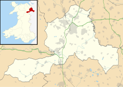
Location within Wrexham
Population2,035 (2011)
OS grid reference SJ332520
Community
Principal area
Country Wales
Sovereign state United Kingdom
Post town WREXHAM
Postcode district LL11
Dialling code 01978
Police North Wales
Fire North Wales
Ambulance Welsh
UK Parliament
Senedd Cymru – Welsh Parliament
List of places
UK
Wales
Wrexham
53°03′40″N2°59′42″W / 53.061°N 2.995°W / 53.061; -2.995
Location of the Garden Village electoral ward in Wrexham County Borough, Wales 2022 Wales Wrexham Ward Garden Village map.svg
Location of the Garden Village electoral ward in Wrexham County Borough, Wales

Garden Village is a suburb of the city of Wrexham and an electoral division (ward) in the community of Rhosddu in Wrexham County Borough, Wales. The population of the ward at the 2011 census was 2,035 [1] It lies to the west of Chester Road and borders the wards of Stansty to the south and east, Gwersyllt East and South to the north west, Little Acton and Acton to the west, and a small section of Gresford to the north.

Contents

History

The land in which 'Garden Village' was built on was originally named 'Mass & Pentre' which was situated South-West of Stansty Hall (which was demolished to give way for new housing around Snowdon Drive). [2] [3]

At the start of the 20th century, housing in many areas of Wrexham was of poor quality and, with the increase in industry locally, in short supply. [4]

The development of Garden Village began with the purchase of some 200 acres (81 hectares) of land from Sir Foster Cunliffe near to the estate of Acton by the Welsh Town Planning and Housing Trust Limited. [5]

The intention was to provide affordable housing to workers coming to Wrexham to work in the expanding industries of coal and iron. Gresford Colliery had recently been opened where it was expected that approximately 3,000 men would be employed in the next two years. [5]

A Co-partnership Housing Society was set up in 1913 called Wrexham Tenants Limited, with Lord Kenyon, Mr. David Davies, M.P., and others as Directors to build the houses, while the Trust would build the roads and supervise the development of the estate. [5]

The original plan, by the architect GL Sutcliffe [4] was to provide a village institute, two places of worship, a school and plenty of open spaces and recreation grounds. [5] The design was inspired by the Garden City Movement and was planned as a Garden Suburb. In the first year, 44 properties were completed; [5] numbers 63-69 Acton Gate, numbers 149–167, Chester Road (originally called Bryn Acton) and Cunliffe Walk. These first house were designed by Sutcliffe and the remaining 205 by Thomas Alwyn Lloyd, architect to the trust. [4]

One of the pioneering features of the development was that the tenants were also investors in the Company thus ensuring control of future development. [4]

Unfortunately, with the advent of World War I, the development lost impetus and no further development was undertaken by Wrexham Tenants Limited. The planned shops, churches, institute and school were never built, although St Margaret's church was built in 1928, partly to the original design of Thomas Alwyn Lloyd. [4]

In 1955, Wrexham Tenants Limited was wound up and the properties sold to the tenants at greatly reduced prices of between £250 and £450. [4]

The ward was proposed to be called "Pentre Yr Ardd" in Welsh by Wrexham County Borough Council for the electoral ward in the final recommendations report. [6] The suggestion was not applied, [7] with "Garden Village" used in Welsh, following the Welsh Language Commissioner's standardisation policy, [8] as the commissioner stated they have no evidence of a used Welsh name for the settlement.

Schools

Churches

Related Research Articles

<span class="mw-page-title-main">Wrexham</span> City in north-east Wales

Wrexham is a city and the administrative centre of Wrexham County Borough in Wales. It is located between the Welsh mountains and the lower Dee Valley, near the border with Cheshire in England. Historically in the county of Denbighshire, and later the county of Clwyd in 1974, it has been the principal settlement of Wrexham County Borough since 1996.

<span class="mw-page-title-main">Wrexham County Borough</span> County borough in Wales

Wrexham County Borough is a county borough, with city status, in the north-east of Wales. It borders the English ceremonial counties of Cheshire and Shropshire to the east and south-east respectively, Powys to the south-west, Denbighshire to the west and Flintshire to the north-west. The city of Wrexham is the administrative centre. The county borough is part of the preserved county of Clwyd.

<span class="mw-page-title-main">Wrexham (UK Parliament constituency)</span> Parliamentary constituency in the United Kingdom, 1918 onwards

Wrexham is a parliamentary constituency centred on the city of Wrexham in the preserved county of Clwyd, Wales in the United Kingdom. It was created in 1918, and is represented in the House of Commons of the UK Parliament from December 2019 by Sarah Atherton of the Conservative Party.

<span class="mw-page-title-main">Acton, Wrexham</span> Community in Wrexham County Borough, Wales

Acton is a suburb and community in Wrexham, Wrexham County Borough, Wales. It spans the north-eastern part of Wrexham. The area is largely residential and at its centre, lies Acton Park, the location of the former Acton Hall.

<span class="mw-page-title-main">Marford</span> Village in Wrexham County Borough, Wales

Marford is a village in Wrexham County Borough, Wales, near the Wales-England border.

<span class="mw-page-title-main">Wrexham (Senedd constituency)</span> Constituency of the Senedd

Wrexham is a constituency of the Senedd. It elects one Member of the Senedd by the first past the post method of election. Also, however, it is one of nine constituencies in the North Wales electoral region, which elects four additional members, in addition to nine constituency members, to produce a degree of proportional representation for the region as a whole.

<span class="mw-page-title-main">Gwersyllt</span> Village in Wales

Gwersyllt is an urban village and community in Wrexham County Borough, Wales.

<span class="mw-page-title-main">Wrexham County Borough Council</span> Local government authority in north-east Wales

Wrexham County Borough Council is the governing body for Wrexham County Borough, a principal area with city status in north Wales, covering Wrexham and the surrounding area.

<span class="mw-page-title-main">Rhosnesni</span> Area of Wrexham, Wales

Rhosnesni is an area and electoral ward in the community of Acton in Wrexham, Wrexham County Borough, Wales. The population of the ward at the 2011 census was 3,683. The settlement developed around the toll gate on Holt Road and was expanded in the late 19th century by the addition of estate houses for the Acton Park estate. Following the breakup of the Acton estate in the 20th century much of the local land was bought up by private developers and Rhosnesni became an urban area.

<span class="mw-page-title-main">Rhosddu</span> Community in Wrexham County Borough, Wales

Rhosddu is a suburb and community in Wrexham County Borough, Wales, covering the north-western parts of the city of Wrexham and comprises the wards of Grosvenor, Garden Village and Stansty.

<span class="mw-page-title-main">Stansty</span> Area of Wrexham, Wales

Stansty is an area and electoral ward in Wrexham County Borough, Wales, lying to the immediate north-west of the city of Wrexham. It is a former civil parish and township. Stansty is also an electoral ward to Wrexham County Borough Council. The ward population as taken at the 2011 Census was 2,114.

Pentre is a village, community and electoral ward near Treorchy in the Rhondda valley, falling within the county borough of Rhondda Cynon Taf, Wales. The village's name is taken from the Welsh word Pentref, which translates as homestead, though Pentre is named after a large farm that dominated the area before the coming of industrialisation. The community takes in the neighbouring village of Ton Pentre.

<span class="mw-page-title-main">Pandy, Gwersyllt</span> Village in Wrexham County Borough, Wales

Pandy is a village near Gwersyllt and Rhosrobin, in Wrexham, Wrexham County Borough, Wales. The main entrance to Gresford Colliery stood in the village. Gresford Colliery Social Club is in the village and alongside it a memorial to the Gresford Disaster, which killed 266 men on September 22, 1934.

<span class="mw-page-title-main">Thomas Alwyn Lloyd</span> Welsh architect and town planner

Thomas Alwyn Lloyd OBE, known as T. Alwyn Lloyd, was a Welsh architect and town planner. He was one of the founders of the Town Planning Institute in 1914 and its President in 1933. He was also a founding member of the Council for the Protection of Rural Wales in 1928 and served as its chairman from 1947 to 1959. Meic Stephens described Lloyd's work as follows:

Lloyd's small-scale buildings reflected his deep feeling for place, in both historical and environmental terms, as in the Garden Villages for which he was responsible in various parts of Wales.

Wrexham North is a proposed railway station on the Shrewsbury–Chester line, situated between Rossett and Wrexham, in Wrexham County Borough, Wales. As of January 2022, there is no definitive site for the proposed station, with proposals including: the former Rossett railway station or a station near Pandy, Wrexham and Gresford. Unless construction of the station south of Rossett coincides with the full or partial dualling of the currently single track railway line towards Stansty, Wrexham North may be a single platform station or if situated at Rossett Junction be linked by a single track southwards to Wrexham.

<span class="mw-page-title-main">2022 Wrexham County Borough Council election</span> Election to Wrexham County Borough Council

The 2022 Wrexham County Borough Council election took place on 5 May 2022 to elect 56 members to Wrexham County Borough Council, the principal council of Wrexham County Borough, Wales. On the same day, elections were held to the other 21 local authorities, and community councils in Wales as part of the 2022 Welsh local elections. The previous Wrexham County Borough all-council election took place in May 2017 and future elections will take place every five years, with the next scheduled for 2027.

Wrexham South is a proposed railway station on the Shrewsbury–Chester line, situated between Chirk and Wrexham, in Wrexham County Borough, Wales. As of January 2022, there is no definitive site for the proposed station, with proposals for the station to be located either near Johnstown or at Rhosymedre on the former Rhosymedre Halt railway station. If the latter location is decided, Ruabon would be the station closest to the south of Wrexham.

<span class="mw-page-title-main">Plas Madoc</span> Housing estate in Wrexham County Borough, Wales

Plas Madoc is a housing estate and former electoral ward near Acrefair, in the Cefn community in Wrexham County Borough, Wales. It is located seven miles to the south-west of Wrexham, and contains The Land adventure playground, and a community-run leisure centre with a swimming pool. The area is one of the most deprived areas in Wales, and the fourth most deprived LSOA in Wrexham County Borough.

References

  1. "Ward population 2011" . Retrieved 18 November 2015.
  2. Electronic reproduction of: Wrexham (Hills), Sheet 121 Originally published 1898.
  3. "Wrexham (Hills), Sheet 121". National Library of Scotland . Edinburgh : National Library of Scotland. 2005 [1898].
  4. 1 2 3 4 5 6 "The History of St Margaret's and Garden Village". Parish of Wrexham. p. 2. Archived from the original on 7 November 2014. Retrieved 7 November 2014.
  5. 1 2 3 4 5 The Garden City Movement Up-To-Date by Ewart G. Culpin (Retrieved 2011-01-11)
  6. "Review of the Electoral Arrangements of the County Borough of Wrexham – Final Recommendations Report" (PDF). ldbc.gov.wales . Local Democracy and Boundary Commission for Wales. November 2020. p. 12. Retrieved 19 January 2022.
  7. "The County Borough of Wrexham (Electoral Arrangements) Order 2021". legislation.gov.uk .
  8. "List of Standardised Welsh Place-names". GOV.WALES. Retrieved 26 December 2021.