Gwynfryn, Wrexham

Last updated

Gwynfryn
Limestone Quarry, Minera - geograph.org.uk - 72267.jpg
Part of the village of Gwynfryn, viewed across a former limestone quarry
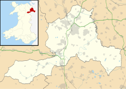
Wrexham UK location map.svg
Red pog.svg
Gwynfryn
Location within Wrexham
OS grid reference SJ259526
Community
Principal area
Ceremonial county
Country Wales
Sovereign state United Kingdom
Post town WREXHAM
Postcode district LL11
Dialling code 01978
Police North Wales
Fire North Wales
Ambulance Welsh
UK Parliament
Senedd Cymru – Welsh Parliament
List of places
UK
Wales
Wrexham
53°03′58″N3°06′22″W / 53.066°N 3.106°W / 53.066; -3.106 Coordinates: 53°03′58″N3°06′22″W / 53.066°N 3.106°W / 53.066; -3.106

Gwynfryn is a hill-top village in the community of Minera in Wrexham County Borough, Wales. Its name, originally that of the village chapel, is formed from the Welsh words bryn, "hill", and gwyn, "white": "white hill". At the time of the 2001 census, its population combined with that of the neighbouring, larger village of Bwlchgwyn was 1,148. [1]

Like the neighbouring villages of Minera and Bwlchgwyn, Gwynfryn is associated with the development of lead mines and limestone quarries in the vicinity. It is situated at the head of the Clywedog Valley in a hilly limestone area. [2] The area was originally known as Plas-Gwyn ("white hall") Mountain, its name on the 1879 and 1900 Ordnance Surveys of Denbighshire, or as Pentre-Bais ("petticoat village"). According to a local story the latter name was changed to Gwynfryn by the disapproving village postmaster (or schoolmaster, in some versions). [3] [4]

There was a Wesleyan Methodist chapel in Gwynfryn, which in 1905 had a congregation of 194. [5] There was also a small Church in Wales chapel, St David's, which as of 2010 has been closed.

The musician, composer and Eisteddfod adjudicator Thomas Carrington (1881–1961) was born in Gwynfryn. [6]
Related Research Articles

Wrexham Town and prospective city in north-east Wales

Wrexham is a market town and the administrative centre of Wrexham County Borough in Wales. It is located between the Welsh mountains and the lower Dee Valley, where it borders with the county of Cheshire in England. Historically in the county of Denbighshire, the town became part of the county of Clwyd in 1974 and then the principal settlement of the Wrexham County Borough in 1996.

Clwyd Preserved county of Wales

Clwyd is a preserved county of Wales, situated in the north-east corner of the country; it is named after the River Clwyd, which runs through the area. To the north lies the Irish Sea, with the English ceremonial counties of Cheshire to the east and Shropshire to the south-east. Powys and Gwynedd lie to the south and west respectively. Clwyd also shares a maritime boundary with Merseyside along the River Dee. Between 1974 and 1996, a slightly different area had a county council, with local government functions shared with six district councils. In 1996, Clwyd was abolished, and the new principal areas of Conwy County Borough, Denbighshire, Flintshire and Wrexham County Borough were created; under this reorganisation, "Clwyd" became a preserved county, with the name being retained for certain ceremonial functions.

Wrexham County Borough County borough in Wales

Wrexham County Borough is a county borough in the north-east of Wales. It borders England to the east and south-east, Powys to the south-west, Denbighshire to the west and Flintshire to the north-west. The county borough has a population of 136,055. The town of Wrexham is its largest settlement, which together with villages such as Gwersyllt, New Broughton, Bradley and Rhostyllen form a built-up area with 65,692 residents. Other villages in the county borough include Ruabon, Rhosllanerchrugog, Johnstown, Acrefair, Bangor-on-Dee, and Coedpoeth amongst other villages. The county borough has two outlying towns, Chirk and Holt, and various rural settlements in the county borough's large salient in the Ceiriog Valley, and the English Maelor.

Rhosllanerchrugog Village in Wales

Rhosllanerchrugog is a village and community in Wrexham County Borough, Wales. It lies within the historic county of Denbighshire. The entire built-up area including Penycae, Ruabon and Cefn Mawr had a population of 25,362.

Coedpoeth Village in Wales

Coedpoeth is a village and community in Wrexham County Borough, Wales. The built-up area with Minera had a population of 5,723 in the 2011 census.

Minera Limeworks

The Minera Limeworks were extensive lime quarries and kilns at Minera in Wrexham, Wales. It was located at grid reference SJ253520, near the villages of Gwynfryn, Minera, and Coedpoeth and was locally referred to as The Calch.

River Clywedog River in Wales

The River Clywedog is a river in Wrexham County Borough, Wales. Its uses have been watering crops, powering industrial machinery but is now used as walking trails or geography trips. The river originates to the west of Wrexham, and joins the River Dee some four miles south east of the town.

Minera Village in Wales

Minera is a village and community in Wrexham County Borough, Wales. It adjoins the village of Coedpoeth.

Bwlchgwyn Human settlement in Wales

Bwlchgwyn is a village in Wrexham County Borough, Wales, on the A525 road, 5 miles (8 km) west of the town of Wrexham and 10 miles (16 km) south-east of the town of Ruthin. Bwlchgwyn is part of the community of Brymbo. In the 2011 Census the population of the village was 855.

Marford Human settlement in Wales

Marford is a village in Wrexham County Borough, Wales, near the Wales-England border.

Brymbo Village in Wales

Brymbo is a village and community in Wrexham County Borough, Wales. It lies in the hilly country to the west of Wrexham town, largely surrounded by farmland.

Erbistock Village in Wales

Erbistock is a village and community in Wrexham County Borough, Wales. The village lies on the banks of the River Dee.

Gwersyllt Village in Wales

Gwersyllt is an urban village and community in Wrexham County Borough, Wales.

Rhosddu Community in Wrexham County Borough, Wales

Rhosddu is a suburb and community in Wrexham County Borough, Wales, covering the north-western parts of the town of Wrexham and comprises the wards of Grosvenor, Garden Village and Stansty.

Garden Village, Wrexham Human settlement in Wales

Garden Village is a suburb of the town of Wrexham and an electoral division (ward) in the community of Rhosddu in Wrexham County Borough, Wales. The population of the ward at the 2011 Census was 2,035 It lies to the west of Chester Road and borders the wards of Stansty to the south and east, Gwersyllt East and South to the north west, Little Acton and Acton to the west, and a small section of Gresford to the north.

Tanyfron Human settlement in Wales

Tanyfron, also occasionally spelt Tan-y-fron, is a village in Wrexham County Borough in Wales. At the time of the 2001 census, the population of area Wrexham 006A, which includes Tanyfron and a number of other small settlements, was 1,347. The village is part of the local government Community of Brymbo and is in the Vron electoral ward. The built-up area had a population of well over 2,000 as of the 2011 census.

Esclusham Mountain is an area in Wrexham County Borough, Wales, United Kingdom, and is part of the Ruabon Moors. It rises to a height of 460 m, with the nearby spur of Cyrn-y-Brain, to the west, reaching 473 m. It lies mostly within the community of Esclusham. A smaller spur to the north, known as Minera Mountain, is within the neighbouring community of Minera.

River Gwenfro River in Wales

The River Gwenfro is a small river in Wrexham County Borough, north Wales. It is a tributary of the Clywedog. The name Gwenfro is possibly derived from the Welsh language words gwen, "white", and bro, "border", "boundary".

Clwydian Range and Dee Valley Area of Outstanding Natural Beauty in Wales

The Clwydian Range and Dee Valley is a designated Area of Outstanding Natural Beauty (AONB) and proposed national park, located in north-east Wales, covering the Clwydian Range, and the valley of the River Dee. Designated in 1985 as the Clwydian Range AONB, and expanded to its current form in 2011, the Area of Outstanding Natural Beauty includes: medieval field systems, open heather moorland, prehistoric hillforts, limestone crags, broad leaved woodland, wooded valleys, and farmland. In 2018, an estimated 1.1 million people visited six key sites across the AONB, generating approximately £24.1 million to the Welsh economy, according to Natural Resources Wales. The AONB falls within the jurisdiction of the local authorities of Denbighshire, Flintshire, and Wrexham County Borough, with the majority, 80% of the AONB in Denbighshire, and the remaining 20% split evenly between the other two authorities. The AONB is the largest of only five AONBs in Wales, and one of the 46 in the United Kingdom. Additionally, it is one of only 8 protected areas of Wales. Long-distance footpaths; Offa's Dyke Path, and the Clwydian Way pass through the AONB. The area of the Clwydian Range and Dee Valley AONB is 390 km2 (150 sq mi), and has been proposed by the Welsh Government to become Wales' fourth national park.

References

  1. National Statistics. "Neighbourhood statistics" . Retrieved 4 March 2007.
  2. Landscape Character Area – Minera, Gwynfryn, Bwlchgwyn, Wrexham County Borough
  3. Minera history, BBC North East Wales
  4. The Wilcoxon Family, Minera History
  5. Minera, GENUKI
  6. Thomas Carrington, National Library of Wales