Holt, Wrexham

Last updated

Holt
The Village of Holt - geograph.org.uk - 3025420.jpg
Holt village
Wrexham UK location map.svg
Red pog.svg
Holt
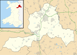
Location within Wrexham
Population1,521 (2011) [1]
OS grid reference SJ409539
Community
  • Holt
Principal area
Preserved county
Country Wales
Sovereign state United Kingdom
Post town Wrexham
Postcode district LL13
Dialling code 01829
Police North Wales
Fire North Wales
Ambulance Welsh
UK Parliament
Senedd Cymru – Welsh Parliament
List of places
UK
Wales
Wrexham

53°04′44″N2°52′52″W / 53.079°N 2.881°W / 53.079; -2.881

Contents

Wales Wrexham Community Holt map.svg
Map of the community

Holt is a medieval village and community in Wrexham County Borough, Wales. It is situated on the border with England and in the historic county of Denbighshire. Holt Castle was begun by Edward I shortly after the English conquest of Wales in 1277. Farndon lies just over the River Dee.

Etymology

The Old English word holt meant a "wood" or "thicket" and is a common element in place names over the border in England. [2] Welsh uses the same name for the village but in the past, it included the definite article, appearing as Yr Holt. [3]

Area

Site of 'Bovium' Roman Tileworks for Legionary Chester Bovium.jpg
Site of 'Bovium' Roman Tileworks for Legionary Chester

The district has been occupied since at least the Roman period. A brickworks (possibly called Bovium) supplied clay tiles and pottery to the Roman fort of Deva Victrix, eight miles away (modern Chester). The works was located just downstream from the modern village. In the early 20th century, six kilns, a bath house, sheds and barracks were found there on the banks of the River Dee.

Three Bronze Age burial urns have also been found in Holt.

Village

St Chad's Church St Chad's Church, Holt.jpeg
St Chad's Church

There is a medieval market cross in the centre of Holt. The church of St Chad has parts dating to the 15th century and 17th century.

Medieval bridge

The bridge between Holt and Farndon upstream on the English side Farndon Bridge.jpg
The bridge between Holt and Farndon upstream on the English side

A Grade I listed 14th-century sandstone bridge links Holt with the English village of Farndon across the River Dee. Records from the county court of Chester in 1368, state that:

"the jury presented that John, earl of Warenne, late Lord of Bromfield, had constructed a bridge across the River Dee (during 1338)... and upon that bridge is a fortified gateway. The jury then claimed that illegal toll was being extorted from workmen daily crossing the bridge, and that the town of Holt was giving shelter to felons who ambushed Cheshire folk."

A survey of 1627 described the bridge:

"contayninge 10 arches which River divideth Two Sheires, namely Cheshire and Denbye... Upon the fifth Arch from Holt standeth a Tower or Gatehouse of Fortification... [the text then describes the Lady's Chapel in the tower]... Upon the other end of the fortificacion next unto the manor of Farndon next unto the Manor of Farndon is layd out in Masons Works a Lyon to the full passant. And like Lyon is upon the gates of Holt Castell. The county of Chester doth repair the bridge to the Lyon."

Sixteen years later, William Brereton attacked the bridge for the Parliamentarians:

"for which end they had also made a towre and drawbridge and strong gates upon the bridge soe as they and wee coceived it difficult if not altogether ympossible to make way for our passage."

Despite this he, Thomas Myddelton and their forces took the bridge on 9 November 1643 when they cast 'some grenados amongst the Welshmen'.

Thomas Pennant recorded ten arches in 1754 (and had been told a datestone of 1354 was there until recently, which contradicts the more likely date of 1338) but Hubbard in Buildings of Wales only saw eight. The third arch, viewed from the Holt river bank, shows the strengthened arch where the drawbridge once stood.

Governance

Map of the Holt electoral ward in Wrexham County Borough, Wales. 2022 Wales Wrexham Ward Holt map.svg
Map of the Holt electoral ward in Wrexham County Borough, Wales.

An electoral ward in the same name exists. This ward stretches west to Abenbury and has a total population taken at the 2011 Census of 3,587. [4]

People from Holt

Related Research Articles

<span class="mw-page-title-main">Chester</span> City in Cheshire, England

Chester is a cathedral city and the county town of Cheshire, England, on the River Dee, close to the England-Wales border. With a built-up area population of 92,760 in 2021, it is the most populous settlement of Cheshire West and Chester. It is also the historic county town of Cheshire and the second-largest settlement in Cheshire after Warrington.

<span class="mw-page-title-main">Farndon, Cheshire</span> Village in England

Farndon is a village and civil parish in the unitary authority of Cheshire West and Chester and the ceremonial county of Cheshire, England. It is on the banks of the River Dee, south of Chester, which here forms the England–Wales border. The Welsh village of Holt lies just over the River Dee from Farndon.

<span class="mw-page-title-main">Hawarden</span> Village in Flintshire, Wales

Hawarden is a village and community in Flintshire, Wales. It is part of the Deeside conurbation on the Wales-England border and is home to Hawarden Castle. In the 2011 census the ward of the same name had a population of 1,887, whereas the community of the same name, which also includes Ewloe Mancot and Aston had a population of 13,920. The scenic wooded Hawarden Park abuts the clustered settlement in the south. Hawarden Bridge consists of distribution and industrial business premises beyond Shotton/Queensferry and the Dee. The west of the main street is called The Highway, its start marked by the crossroads with a fountain in the middle, near which are public houses, some with restaurants.

<span class="mw-page-title-main">Flintshire</span> County in Wales

Flintshire is a county in the north-east of Wales. It borders the English ceremonial counties of Merseyside and Cheshire, across the Dee Estuary to the north and by land to the east respectively, Wrexham County Borough to the south, and Denbighshire to the west. Connah's Quay is the largest town, while Flintshire County Council is based in Mold.

<span class="mw-page-title-main">Flintshire (historic)</span> Historic county of Wales

Until 1974, Flintshire, also known as the County of Flint, was an administrative county in the north-east of Wales, later classed as one of the thirteen historic counties of Wales.

<span class="mw-page-title-main">Bangor-on-Dee</span> Village in Wales

Bangor-on-Dee is a village and community in Wrexham County Borough, Wales, on the banks of the River Dee. Until 1974 it was in the exclave of Flintshire known as the Maelor Saesneg, and from 1974 to 1996 in the county of Clwyd.

<span class="mw-page-title-main">River Dee, Wales</span> River in Wales and England

The River Dee is a river flowing through North Wales, and through Cheshire, England, in Great Britain. The length of the main section from Bala to Chester is 113 km and it is largely located in Wales. The stretch between Aldford and Chester is within England, and two other sections form the border between the two countries.

<span class="mw-page-title-main">Wrexham County Borough</span> County borough in Wales

Wrexham County Borough is a county borough, with city status, in the north-east of Wales. It borders the English ceremonial counties of Cheshire and Shropshire to the east and south-east respectively along the England–Wales border, Powys to the south-west, Denbighshire to the west and Flintshire to the north-west. The city of Wrexham is the administrative centre. The county borough is part of the preserved county of Clwyd.

<span class="mw-page-title-main">Overton-on-Dee</span> Village in Wales

Overton or Overton-on-Dee is a village and community in Wrexham County Borough, Wales. It is situated close to the Welsh-English border on the edge of an escarpment that winds its way around the course of the River Dee, from which Overton-on-Dee derives its name.

<span class="mw-page-title-main">Deeside</span> Cross-border conurbation in England and in Wales

Deeside is the name given to a predominantly industrial conurbation of towns and villages in Flintshire and Cheshire on the Wales–England border lying near the canalised stretch of the River Dee that flows from neighbouring Chester into the Dee Estuary. These include Connah's Quay, Shotton, Queensferry, Aston, Garden City, Sealand, Broughton, Bretton, Hawarden, Ewloe, Mancot, Pentre, Saltney and Sandycroft. The population is around 50,000, with a plurality (17,500) living in Connah's Quay.

<span class="mw-page-title-main">Handbridge</span> Human settlement in England

Handbridge is a district of Chester, England on the south bank of the River Dee. A settlement has existed on the site since the Iron Age, but the site saw major expansion during the collapse of the Roman occupation of Britain, as the city grew too large for its walls. The site was originally mainly a quarry for the abundant red sandstone that much Chester is built from, but in later years became a centre for salmon fishing in the Dee.

<span class="mw-page-title-main">Old Dee Bridge</span> Bridge in Cheshire, England

The Old Dee Bridge in Chester, Cheshire, England, is the oldest bridge in the city. It crosses the River Dee carrying the road that leads from the bottom of Lower Bridge Street and the Bridgegate to Handbridge. A bridge on this site was first built in the Roman era, and the present bridge is largely the result of a major rebuilding in 1387. It is recorded in the National Heritage List for England as a designated Grade I listed building, and is a scheduled monument.

Farndon is a civil parish in Cheshire West and Chester, England. It contains 19 buildings that are recorded in the National Heritage List for England as designated listed buildings. One of these is listed at Grade I, the highest grade, three at the middle grade, Grade II*, and the rest at the lowest grade, Grade II. Apart from the village of Farndon, the parish is rural. The listed buildings include houses in the village, the church and tombs in the churchyard, the ancient bridge crossing the River Dee, the former village lock-up, and a memorial.

<span class="mw-page-title-main">Rossett</span> Village in Wrexham County Borough, Wales

Rossett is a village, community and electoral ward in Wrexham County Borough, Wales. Rossett is served by the A483 road.

<span class="mw-page-title-main">Grosvenor Bridge (Chester)</span> Bridge in Chester

The Grosvenor Bridge is a single-span stone arch road bridge crossing the River Dee at Chester, England. Located on the A483 Grosvenor Road, it was designed by Thomas Harrison and opened by Princess Victoria of Saxe-Coburg-Saalfeld on 17 October 1832. The first traffic passed over it in November 1833.

<span class="mw-page-title-main">Thomas Penson</span> Welsh architect and engineer

Thomas Penson, or Thomas Penson the younger, was the county surveyor of Denbighshire and Montgomeryshire, and an innovative architect and designer of a number of masonry arch bridges over the River Severn and elsewhere.

<span class="mw-page-title-main">History of Wrexham</span>

The city of Wrexham in north-east Wales has a history dating back to ancient times. The former market town was the site of heavy industry in the 19th and 20th centuries, and is now an active commercial centre. Wrexham was granted city status in 2022.

<span class="mw-page-title-main">Holt Castle</span> Castle ruins in Holt, Wrexham, Wales

Holt Castle was a medieval castle in the village of Holt, Wrexham County Borough, Wales. Work began in the 13th century during the Welsh Wars, the castle was sited on the Welsh–English border by the banks of the River Dee.

<span class="mw-page-title-main">Farndon Bridge</span> Bridge between England and Wales

Farndon Bridge, also known as Holt Bridge, crosses the River Dee and the England-Wales border between the villages of Farndon, Cheshire, England and Holt, Wrexham, Wales. The bridge, which was built in the mid-14th century, is recorded in the National Heritage List for England and by Cadw as a designated Grade I listed building and scheduled monument. It is built from locally quarried red sandstone and had eight arches, of which five are over the river. On the Farndon side there is one flood arch and two flood arches are on the Holt side.

There are over 9,000 Grade I listed buildings in England. This page is a list of these buildings in the unitary authority of Cheshire West and Chester.

References

  1. "Community population 2011". Archived from the original on 19 November 2015. Retrieved 18 November 2015.
  2. Mills, A. D. (2003). A Dictionary of British Place-Names. Oxford: Oxford University Press. ISBN   9780198527589.
  3. Hywel Wyn Owen a Richard Morgan, Dictionary of the Place-names of Wales (Gwasg Prifysgol Cymru, 2007), tud. 196
  4. "Ward population 2011" . Retrieved 18 November 2015.
  5. Bowman, Jamie (3 October 2016). "Teaching spell near Wrexham inspired one of the nation's greatest science fiction writers". The Leader . Wrexham. Retrieved 13 May 2018.

Further reading