Offa | |
---|---|
Location within Wrexham | |
Population | 10,501 |
Principal area | |
Preserved county | |
Country | Wales |
Sovereign state | United Kingdom |
Post town | WREXHAM |
Postcode district | LL11, LL13, LL14 |
Dialling code | 01978 |
Police | North Wales |
Fire | North Wales |
Ambulance | Welsh |
UK Parliament | |
Senedd Cymru – Welsh Parliament | |
Website | https://www.offacommunitycouncil.gov.uk/ |
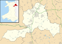
Offa is a community and electoral ward in Wrexham County Borough, Wales, covering most of the south-western portion of the city of Wrexham. It is bordered by the communities of; Rhosddu, and Caia Park to the north, Abenbury to the east, Esclusham, and Marchwiel to the south, and Broughton, Coedpoeth, and Gwersyllt to the west.
According to Howard Williams and Liam Delaney, a Professor of Archaeology and Doctoral Researcher respectively, at the University of Chester, the area is named after Bryn Offa (Welsh for Offa's Hill), a housing estate and former hall located currently within the community. Bryn Offa itself is actually named after Wat's Dyke which historically passes through the community, as historically there was no distinction between Wat's and Offa's Dyke, leading to local confusion. Williams and Delaney state that such distinction between the two dykes was only made by the nineteenth century at earliest. [1]
Unlike many such community areas in Wales, Offa was not based on the boundaries of an earlier civil parish or township, although it corresponds roughly to some of the areas included in the old township of Wrexham Abbott. It was first established only in April 1985, after a boundary review bought four new 'urban' communities into being within the then town of Wrexham. [2] The community has four wards, Erddig, Brynyffynnon, Hermitage, and Offa. The Community Council states that it was noted in a Welsh Assembly report as one of the most "active and innovative" in Wales. [2]
At the 2001 census, the community had a total population of 9,852 in 4,294 households, [3] the population increasing to 10,501 at the 2011 census. [4] Following the Hermitage ward's inclusion in the top 10% of the Welsh Index of Multiple Deprivation, Offa Community has been involved in the Welsh Assembly's Communities First regeneration programme. [5]
Offa is bounded by the A483 dual carriageway to most of its west, stopping before Bersham, where it arbitrarily curves around until reaching the River Clywedog near Bersham Road. The river forms the community's southern boundary until its confluence with the River Dee which continues the border to the King's Mill. It then follows the A525 until reaching Eagles Meadow which via Mount Street it curves around reaching Wrexham's High Street, Regent Street, and the A541 until closing with the A483.
The community of Offa covers much of the south-western part of the city of Wrexham, including St. Giles' Church, Wrexham Central station, Wrexham Maelor Hospital, Wrexham Technology Park, and Bellevue Park. It covers large residential areas, including the areas known as Hightown, Brynyffynnon and Felin Puleston, as well as the part of the grounds of Erddig not within the neighbouring communities of Esclusham, and Marchwiel. Its easternmost sections are regarded to be part of Hightown.
Wrexham is a city and the administrative centre of Wrexham County Borough in Wales. It is located between the Welsh mountains and the lower Dee Valley, near the border with Cheshire in England. Historically in the county of Denbighshire, and later the county of Clwyd in 1974, it has been the principal settlement of Wrexham County Borough since 1996.
The Maelor is an area of north-east Wales along the border with England. It is now entirely part of Wrexham County Borough. The name Maelor is an old Welsh word: it can be translated as "land of the prince", from mael ("prince") and llawr.
Wrexham County Borough is a county borough, with city status, in the north-east of Wales. It borders the English ceremonial counties of Cheshire and Shropshire to the east and south-east respectively along the England–Wales border, Powys to the south-west, Denbighshire to the west and Flintshire to the north-west. The city of Wrexham is the administrative centre. The county borough is part of the preserved county of Clwyd.
Erddig is a country house and estate in the community of Marchwiel, approximately 2 miles (3.2 km) south of Wrexham, Wales. It is centred on a country house which dates principally from between 1684 and 1687, when the central block was built by Joshua Edisbury, and the 1720s, when the flanking wings were added by its second owner, John Meller. Erddig was inherited by Simon Yorke in 1733, and remained in the Yorke family until it was given to the National Trust by Philip Yorke III in 1973.
The River Clywedog is a river in Wrexham County Borough, Wales. Its uses have been watering crops, powering industrial machinery but is now used as walking trails or geography trips. The river originates to the west of Wrexham, and joins the River Dee some four miles south east of the city.
Brymbo is a village and community in Wrexham County Borough, Wales. It lies in the hilly country to the west of Wrexham city, largely surrounded by farmland.
Ysgol Clywedog is a comprehensive secondary school which serves parts of the city of Wrexham in north-east Wales, in the community of Offa.
Ysgol Morgan Llwyd is a Welsh-medium comprehensive school in Wrexham, in north-east Wales, UK. It is the first, and is the only Welsh-medium secondary school in Wrexham County Borough. It is named after the seventeenth-century preacher and author Morgan Llwyd. The school has been open at its present location in Cefn Road since 2000. Previously it was located on Stockwell Grove. The Headteacher is Ms. Catrin Prichard.
Stansty is an area and electoral ward in Wrexham County Borough, Wales, lying to the immediate north-west of the city of Wrexham. It is a former civil parish and township. Stansty is also an electoral ward to Wrexham County Borough Council. The ward population as taken at the 2011 Census was 2,114.
Bersham is a village in Wrexham County Borough, Wales, that lies next to the River Clywedog, and is in the community of Esclusham. Bersham was historically a major industrial centre of the area, but despite this the village still retains a rural feeling.
The Clywedog Trail is a 9-mile (14 km) footpath close to Wrexham in Wales. Starting at the Minera Lead Mines (53.0512°N 3.0811°W) and running to King's Mills (53.0358°N 2.9750°W), it follows the course of the River Clywedog. It is a haven for walking, relaxation and enjoying the peace of the wildlife. The Clywedog region played a role in the Industrial Revolution; ironmaking began in 1670, smelting iron ore with coke began in 1721 and John Wilkinson set up shop in 1761. For many years the area was one of the most important iron manufacturing centres in the world.
Bryn Offa is a local-authority housing estate in the south-western suburbs of the city of Wrexham, in Wrexham County Borough, north-east Wales in the community of Offa, and is close to the Wrexham Maelor Hospital.
The city of Wrexham in north-east Wales has a history dating back to ancient times. The former market town was the site of heavy industry in the 19th and 20th centuries, and is now an active commercial centre. Wrexham was granted city status in 2022.
Rhostyllen is a village in Wrexham County Borough, Wales, south-west of the city of Wrexham. At the time of the 2001 census, area Wrexham 014A, which includes Rhostyllen itself, had a population of 1,383 in 599 households.
The city of Wrexham has two main city parks, these being Bellevue Park and Acton Park. On the outskirts of the city there is also open parkland on and surrounding the Erddig estate. There is also a city centre green and various smaller parks and open spaces.
Marchwiel is a village and community in Wrexham County Borough, Wales.
Esclusham is a community and electoral ward in Wrexham County Borough, Wales.
{{cite journal}}
: CS1 maint: date and year (link)