
Wrexham is a city and the administrative centre of Wrexham County Borough in Wales, between the Welsh mountains and the lower Dee Valley, near the border with Cheshire in England. Historically in the county of Denbighshire, and later the county of Clwyd in 1974, it has been the principal settlement of Wrexham County Borough since 1996.
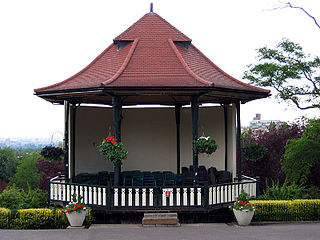
A bandstand is a circular, semicircular or polygonal structure set in a park, garden, pier, or indoor space, designed to accommodate musical bands performing concerts. A simple construction, it both creates an ornamental focal point and also serves acoustic requirements while providing shelter for the changeable weather, if outdoors. In form bandstands resemble ornamental European garden gazebos modeled on outdoor open-sided pavilions found in Asian countries from early times.

Kelvingrove Park is a public park located on the River Kelvin in the West End of the city of Glasgow, Scotland, containing the Kelvingrove Art Gallery and Museum.

Belle Vue is a suburb of the town of Shrewsbury, Shropshire. It is located about a mile south of the town centre. The population of the ward at the 2011 census was 4,550.
Brynmill is a suburb of the City and County of Swansea, Wales, UK. It lies about two miles (3 km) to the west of Swansea city centre. It is a residential area forming the southern part of the Uplands electoral ward. As it is close to Swansea University, many students choose to rent rooms here during term time. Aside from the student population, this is a fairly middle-class area.
Belle Vue Park is a large Victorian public park in the west of the city of Newport, in South Wales. It was awarded a Green Flag Award in 2008 and has maintained the status for over a decade since. The park is listed on the Cadw/ICOMOS Register of Parks and Gardens of Special Historic Interest in Wales.

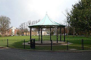
Acton is a suburb and community in Wrexham, Wrexham County Borough, Wales. It spans the north-eastern part of Wrexham. The area is largely residential and at its centre, lies Acton Park, the location of the former Acton Hall.
Ponciau is a village within the community of Rhosllanerchrugog, Wrexham County Borough, Wales. It is close to the villages of Legacy, Pentre Bychan, and Johnstown and is overlooked by Ruabon Mountain.

Southwark Park is located in Rotherhithe, in central South East London, England, and is managed by the London Borough of Southwark. It first opened in 1869 by the Metropolitan Board of Works as one of its first parks. It was designed by Alexander McKenzie and covers 63 acres (250,000 m2). It takes its name from being in what was the old Parliamentary constituency of Southwark at the time of its opening.
The city of Wrexham in north-east Wales has a history dating back to ancient times. The former market town was the site of heavy industry in the 19th and 20th centuries, and is now an active commercial centre. Wrexham was granted city status in 2022.
Llwyn Isaf, also known as the Library Field, is a green space in the centre of Wrexham. It is surrounded on two sides by the city's guildhall and on another by the library.
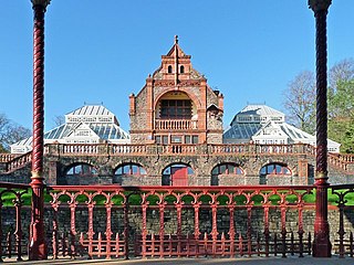
The city of Wrexham has two main city parks, these being Bellevue Park and Acton Park. On the outskirts of the city there is also open parkland on and surrounding the Erddig estate. There is also a city centre green and various smaller parks and open spaces.
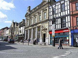
Wrexham city centre is the administrative, cultural and historic city centre of Wrexham, in North Wales and is the area enclosed by the inner ring road of the city. It is the largest shopping area in north and mid Wales, and the administrative centre of Wrexham County Borough. Many of its streets are pedestrianised.

Offa is a community and electoral ward in Wrexham County Borough, Wales, covering most of the south-western portion of the city of Wrexham. It is bordered by the communities of; Rhosddu, and Caia Park to the north, Abenbury to the east, Esclusham, and Marchwiel to the south, and Broughton, Coedpoeth, and Gwersyllt to the west.

Roberts Park is a 14 acres (5.7 ha) public urban park in Saltaire, West Yorkshire, England. Higher Coach Road, Baildon, is to the north and the park is bounded to the south by the River Aire. A pedestrian footbridge crosses the Aire and links the park to the village of Saltaire. The park is an integral part of the Saltaire World Heritage site.

Ropner Park is a free public park, located in Stockton-on-Tees, County Durham, England.

Wormholt Park is a 7.75 acres (3.14 ha) urban park in the London Borough of Hammersmith and Fulham, near White City, Shepherd's Bush.

Waterloo Park is a Grade II* listed public park in Norwich, Norfolk. It forms one of a set of public parks established in Norwich in the 1930s by Captain Arnold Sandys-Winsch that were built by unemployed men using government funding. The original open space, then known as the Catton Recreation Ground, was opened as Waterloo Park in May 1904. When the redesigned park was opened in 1933, it was considered to be the finest in East Anglia, with a pavilion in the style of Moderne architecture, a bandstand, sports facilities, gardens and a children's playground. The herbaceous border is one of the longest in the United Kingdom located within a public space.

Northbrook Park is a public park located on Baring Road south of Lee Green and north of Grove Park in the London Borough of Lewisham, southeast London, England. It is roughly 9 acres (3.6 ha) in size, and contains a large central field bounded by trees, a children's playground, with a sandpit and splash pool, a multipurpose game court, two football pitches, and outdoor gym equipment. The park was previously a field named Ten-Acre Field, despite actually being 7 acres (2.8 ha), and part of the Baring Estate of Lee. In 1898, Thomas Baring, 1st Earl of Northbrook gifted part of his family's estate to public use in commemoration of the Diamond Jubilee of Queen Victoria. The Park was designed by Lt Col J J Sexby, Chief Officer of the London County Council's Parks Department, then was officially opened on 14 March 1903. In the past the park contained a larger playground, a paddling pool, a "legal" graffiti wall, a pond, a bowling green and a tennis court.

Chester Street is a street in Wrexham city centre, North Wales. It was once a main north–south road on the edge of the centre of Wrexham. The street has several listed buildings, as well as Wrexham's civic centre containing various council, memorial and leisure buildings, Coleg Cambria's Yale campus, Tŷ Pawb and various historical buildings now demolished.

